Property Record
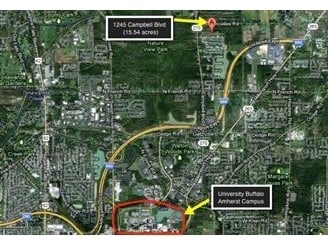
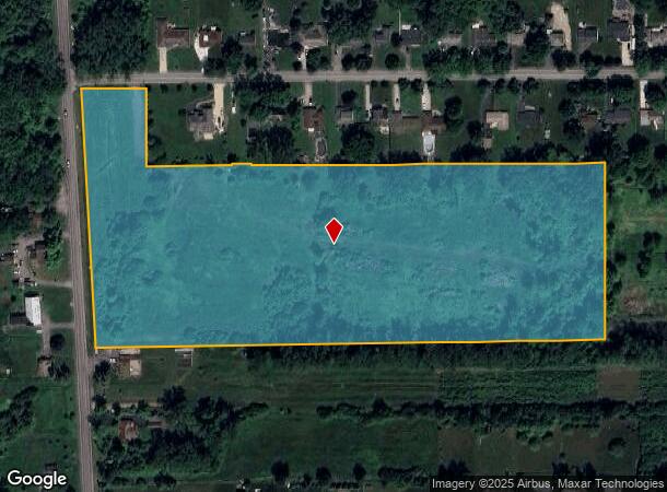
1245 Campbell Blvd, Buffalo, NY 14228
NEARBY LISTINGS FOR SALE OR LEASE
Property Detail
1245 Campbell Blvd
142289-027-070-0002-006-000
Erie
Agriculturalland
New York
AE
6.000
36029C0067H
15.54 AC
2025
North
2024
Buffalo/Niagara Falls
009009
Buffalo-Cheektowaga-Niagara Falls, NY
DEMOGRAPHICS near 1245 Campbell Blvd
1 Mile
3 Mile
5 Mile
2024 Total Population
1,810
32,209
121,173
2029 Population
1,718
31,972
120,653
Pop Growth 2024-2029
(5.08%)
(0.74%)
(0.43%)
Average Age
41
42
42
2024 Total Households
719
13,130
47,664
HH Growth 2024-2029
(5.42%)
(0.54%)
(0.39%)
Median Household Inc
$143,323
$86,374
$82,653
Avg Household Size
2.50
2.40
2.30
2024 Avg HH Vehicles
2.00
2.00
2.00
Median Home Value
$545,393
$292,237
$260,014
Median Year Built
2001
1982
1977
Nearby Places
- Restaurants
- Banks
- Shops
- Fitness
- Groceries
PUBLIC TRANSPORTATION
AIRPORT
Buffalo Niagara International
DRIVE
WALK
Distance
Buffalo Niagara International
20 min
9.4 mi
Niagara Falls International
DRIVE
WALK
Distance
Niagara Falls International
22 min
12.4 mi
Freight Ports
Albany, NY Port
DRIVE
WALK
Distance
Albany, NY Port
341 min
290.6 mi
SALE & LEASE HISTORY
LISTING DATE
SALE/LEASE

Sep 24, 2016
For Sale
Nearby Properties
Address
Land Use
TOTAL SIZE
Lot Size
Zoning
Address
Land Use
TOTAL SIZE
Lot Size
Zoning
5,472 SF
70.10 AC
Address
Land Use
TOTAL SIZE
Lot Size
Zoning
283,706 SF
68.90 AC
Address
Land Use
TOTAL SIZE
Lot Size
Zoning
41,104 SF
27.52 AC
Address
Land Use
TOTAL SIZE
Lot Size
Zoning
2,592 SF
22.75 AC
NCD
Address
Land Use
TOTAL SIZE
Lot Size
Zoning
213,943 SF
5.50 AC
Address
Land Use
TOTAL SIZE
Lot Size
Zoning
403,248 SF
53.50 AC
Address
Land Use
TOTAL SIZE
Lot Size
Zoning
83,256 SF
8.01 AC
NCD
Address
Land Use
TOTAL SIZE
Lot Size
Zoning
253,920 SF
22.83 AC
RD
Address
Land Use
TOTAL SIZE
Lot Size
Zoning
6,384 SF
13.40 AC
Address
Land Use
TOTAL SIZE
Lot Size
Zoning
11,248 SF
21.70 AC
MFR-5
Address
Land Use
TOTAL SIZE
Lot Size
Zoning
154,296 SF
7.90 AC
RD
Address
Land Use
TOTAL SIZE
Lot Size
Zoning
28,530 SF
30.20 AC
NCD
Address
Land Use
TOTAL SIZE
Lot Size
Zoning
12,132 SF
12.30 AC
Address
Land Use
TOTAL SIZE
Lot Size
Zoning
112,256 SF
38.33 AC
00000
Address
Land Use
TOTAL SIZE
Lot Size
Zoning
96,554 SF
10.90 AC
Address
Land Use
TOTAL SIZE
Lot Size
Zoning
110,243 SF
19.06 AC
Address
Land Use
TOTAL SIZE
Lot Size
Zoning
87,718 SF
1.26 AC
RD
Address
Land Use
TOTAL SIZE
Lot Size
Zoning
49,478 SF
4 AC
NCD
Address
Land Use
TOTAL SIZE
Lot Size
Zoning
128,867 SF
9.42 AC
RD
Address
Land Use
TOTAL SIZE
Lot Size
Zoning
106,676 SF
8.90 AC
RD
Address
Land Use
TOTAL SIZE
Lot Size
Zoning
270,320 SF
12.20 AC
Address
Land Use
TOTAL SIZE
Lot Size
Zoning
136,200 SF
4.10 AC
Address
Land Use
TOTAL SIZE
Lot Size
Zoning
131,200 SF
16.90 AC
Address
Land Use
TOTAL SIZE
Lot Size
Zoning
39,454 SF
4.81 AC
GC
Address
Land Use
TOTAL SIZE
Lot Size
Zoning
131,128 SF
15.48 AC
RD
Address
Land Use
TOTAL SIZE
Lot Size
Zoning
81,920 SF
3.82 AC
Address
Land Use
TOTAL SIZE
Lot Size
Zoning
92,368 SF
0.75 AC
RD
Address
Land Use
TOTAL SIZE
Lot Size
Zoning
63,464 SF
2.44 AC
Address
Land Use
TOTAL SIZE
Lot Size
Zoning
86,640 SF
10.30 AC
RD
Address
Land Use
TOTAL SIZE
Lot Size
Zoning
74,655 SF
29.46 AC
The World's #1 Commercial Real Estate Marketplace
Connect with us
© 2025 CoStar Group
The information above has been obtained from sources believed reliable. While we do not doubt its accuracy we have not verified it and make no guarantee, warranty or representation about it. It is your responsibility to independently confirm its accuracy and completeness. Any projections, opinions, assumptions, or estimates used are for example only and do not represent the current or future performance of the property. The value of this transaction to you depends on tax and other factors which should be evaluated by your tax, financial, and legal advisors. You and your advisors should conduct a careful, independent investigation of the property to determine to your satisfaction the suitability of the property for your needs.