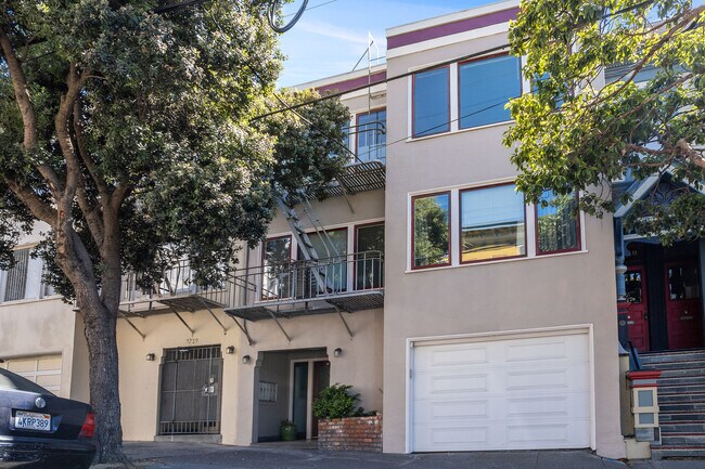
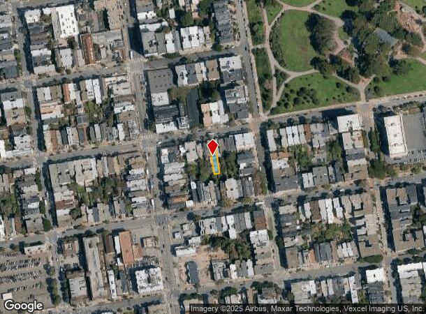
Property Record
1245 Hayes St, San Francisco, CA 94117

NEARBY LISTINGS FOR SALE OR LEASE
Property Detail
1245 Hayes St
San Francisco
Portion Of Western Addition
San Francisco-Redwood City-South San Francisco, CA
BLK 446
1203-031
San Francisco
Apartment
California
2024
31
2025
0.08 AC
016400
Hayes Valley
3,600 SF
DEMOGRAPHICS near 1245 Hayes St
1 Mile
3 Mile
5 Mile
2024 Total Population
97,405
558,540
800,622
2029 Population
90,607
520,020
739,873
Pop Growth 2024-2029
(6.98%)
(6.90%)
(7.59%)
Average Age
41
42
42
2024 Total Households
46,794
261,650
338,229
HH Growth 2024-2029
(7.48%)
(7.42%)
(7.91%)
Median Household Inc
$142,544
$133,860
$126,315
Avg Household Size
1.90
2.00
2.20
2024 Avg HH Vehicles
1.00
1.00
1.00
Median Home Value
$1,088,909
$1,109,585
$1,097,454
Median Year Built
1948
1949
1949
Nearby Places
Map Layers
Map Styles
 Street
 Aerial
- Restaurants
- Banks
- Shops
- Fitness
- Groceries
PUBLIC TRANSPORTATION
TRANSIT/SUBWAY
Duboce and Noe (N Judah - San Francisco Municipal Railway (MUNI Metro))
DRIVE
WALK
Distance
Duboce and Noe (N Judah - San Francisco Municipal Railway (MUNI Metro))
2 min
10 min
0.5 mi
Church St & Duboce Ave (J Church - San Francisco Municipal Railway (MUNI Metro))
DRIVE
WALK
Distance
Church St & Duboce Ave (J Church - San Francisco Municipal Railway (MUNI Metro))
3 min
15 min
0.8 mi
Market and Sanchez (F Market - San Francisco Municipal Railway (MUNI Metro))
DRIVE
WALK
Distance
Market and Sanchez (F Market - San Francisco Municipal Railway (MUNI Metro))
4 min
17 min
0.9 mi
Market and Church Inbound (F Market - San Francisco Municipal Railway (MUNI Metro))
DRIVE
WALK
Distance
Market and Church Inbound (F Market - San Francisco Municipal Railway (MUNI Metro))
4 min
17 min
0.9 mi
Market and Laguna/Guerrero (F Market - San Francisco Municipal Railway (MUNI Metro))
DRIVE
WALK
Distance
Market and Laguna/Guerrero (F Market - San Francisco Municipal Railway (MUNI Metro))
4 min
19 min
1.0 mi
COMMUTER RAIL
San Francisco 4th & King (Caltrain - Caltrain (Caltrain))
DRIVE
WALK
Distance
San Francisco 4th & King (Caltrain - Caltrain (Caltrain))
7 min
3.3 mi
DRIVE
WALK
Distance
7 min
3.3 mi
AIRPORT
San Francisco International
DRIVE
WALK
Distance
San Francisco International
24 min
14.2 mi
Metro Oakland International
DRIVE
WALK
Distance
Metro Oakland International
34 min
21.7 mi
Norman Y Mineta San Jose International
DRIVE
WALK
Distance
Norman Y Mineta San Jose International
59 min
45.9 mi
Freight Ports
Port of San Francisco
DRIVE
WALK
Distance
Port of San Francisco
10 min
3.9 mi
SALE & LEASE HISTORY
LISTING DATE
SALE/LEASE

Sep 29, 2022
For Sale
Nearby Properties
Address
Land Use
TOTAL SIZE
Lot Size
Zoning
Address
Land Use
TOTAL SIZE
Lot Size
Zoning
1,015,000 SF
2.43 AC
RC4
Address
Land Use
TOTAL SIZE
Lot Size
Zoning
764,661 SF
0.67 AC
C3OSD
Address
Land Use
TOTAL SIZE
Lot Size
Zoning
750,370 SF
3.25 AC
MBR3
Address
Land Use
TOTAL SIZE
Lot Size
Zoning
1,471,929 SF
1.93 AC
C3O
Address
Land Use
TOTAL SIZE
Lot Size
Zoning
1,300,000 SF
1.74 AC
C3O
Address
Land Use
TOTAL SIZE
Lot Size
Zoning
1,420,430 SF
1.16 AC
C3OSD
Address
Land Use
TOTAL SIZE
Lot Size
Zoning
1,534,312 SF
2.60 AC
C3O
Address
Land Use
TOTAL SIZE
Lot Size
Zoning
914,037 SF
1.36 AC
C3O
Address
Land Use
TOTAL SIZE
Lot Size
Zoning
248,303 SF
4.35 AC
Address
Land Use
TOTAL SIZE
Lot Size
Zoning
717,234 SF
3.47 AC
UMU
Address
Land Use
TOTAL SIZE
Lot Size
Zoning
605,459 SF
0.63 AC
C3O
Address
Land Use
TOTAL SIZE
Lot Size
Zoning
475,791 SF
0.55 AC
C3OSD
Address
Land Use
TOTAL SIZE
Lot Size
Zoning
690,442 SF
0.79 AC
C3O
Address
Land Use
TOTAL SIZE
Lot Size
Zoning
10.92 AC
Address
Land Use
TOTAL SIZE
Lot Size
Zoning
750,491 SF
0.51 AC
C3O
Address
Land Use
TOTAL SIZE
Lot Size
Zoning
432,000 SF
0.35 AC
C3OSD
Address
Land Use
TOTAL SIZE
Lot Size
Zoning
266,143 SF
4 AC
C-3-R
Address
Land Use
TOTAL SIZE
Lot Size
Zoning
885,581 SF
5.20 AC
M2
Address
Land Use
TOTAL SIZE
Lot Size
Zoning
512,395 SF
1.24 AC
C3O
Address
Land Use
TOTAL SIZE
Lot Size
Zoning
508,714 SF
1.29 AC
C3R
Address
Land Use
TOTAL SIZE
Lot Size
Zoning
1,084,662 SF
1.67 AC
C3O
Address
Land Use
TOTAL SIZE
Lot Size
Zoning
505,120 SF
0.41 AC
C3O
Address
Land Use
TOTAL SIZE
Lot Size
Zoning
694,334 SF
1.01 AC
C3O
Address
Land Use
TOTAL SIZE
Lot Size
Zoning
696,431 SF
0.97 AC
C3G
Address
Land Use
TOTAL SIZE
Lot Size
Zoning
139,070 SF
0.64 AC
C3O
Address
Land Use
TOTAL SIZE
Lot Size
Zoning
1.52 AC
C3G
Address
Land Use
TOTAL SIZE
Lot Size
Zoning
1,424,230 SF
2.60 AC
C3G
Address
Land Use
TOTAL SIZE
Lot Size
Zoning
614,740 SF
1.74 AC
C3OSD
Address
Land Use
TOTAL SIZE
Lot Size
Zoning
615,957 SF
0.63 AC
C3O
Address
Land Use
TOTAL SIZE
Lot Size
Zoning
492,980 SF
0.43 AC
C3O
The World's #1 Commercial Real Estate Marketplace
Connect with us
© 2025 CoStar Group
The information above has been obtained from sources believed reliable. While we do not doubt its accuracy we have not verified it and make no guarantee, warranty or representation about it. It is your responsibility to independently confirm its accuracy and completeness. Any projections, opinions, assumptions, or estimates used are for example only and do not represent the current or future performance of the property. The value of this transaction to you depends on tax and other factors which should be evaluated by your tax, financial, and legal advisors. You and your advisors should conduct a careful, independent investigation of the property to determine to your satisfaction the suitability of the property for your needs.