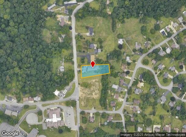
Property Record
1245 Maple Street Ext, Coraopolis, PA 15108

NEARBY LISTINGS FOR SALE OR LEASE
Property Detail
1245 Maple Street Ext
Pittsburgh, PA
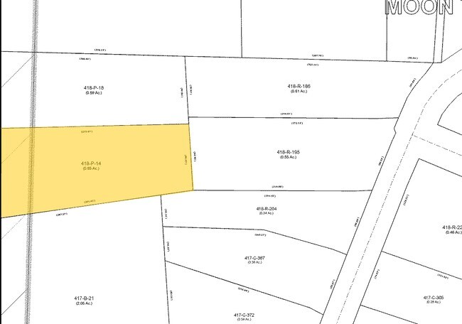
Wilken Subdivision
0418-P-00014-0000-00
WILKEN SUBDIVISION PLAN 2 LOT 96XAVG277.18X75 (OR .543 AC) MAPLE ST EXT
Autorepair
Allegheny
X
Pennsylvania
42007C0295D
14
2024
0.54 AC
2025
West Pittsburgh
451300
Pittsburgh
DEMOGRAPHICS near 1245 Maple Street Ext
1 Mile
3 Mile
5 Mile
2024 Total Population
3,703
35,328
80,533
2029 Population
3,635
34,624
78,766
Pop Growth 2024-2029
(1.84%)
(1.99%)
(2.19%)
Average Age
44
42
42
2024 Total Households
1,507
14,713
33,746
HH Growth 2024-2029
(1.92%)
(2.17%)
(2.34%)
Median Household Inc
$85,750
$85,411
$91,140
Avg Household Size
2.40
2.20
2.30
2024 Avg HH Vehicles
2.00
2.00
2.00
Median Home Value
$253,090
$255,902
$261,135
Median Year Built
1962
1964
1971
Nearby Places
Map Layers
Map Styles
 Street
 Aerial
- Restaurants
- Banks
- Shops
- Fitness
- Groceries
PUBLIC TRANSPORTATION
AIRPORT
Pittsburgh International
DRIVE
WALK
Distance
Pittsburgh International
11 min
4.2 mi
Freight Ports
Port of Toledo
DRIVE
WALK
Distance
Port of Toledo
255 min
223.9 mi
Nearby Properties
Address
Land Use
TOTAL SIZE
Lot Size
Zoning
Address
Land Use
TOTAL SIZE
Lot Size
Zoning
3,320 SF
180.98 AC
Address
Land Use
TOTAL SIZE
Lot Size
Zoning
3,827 SF
59.64 AC
Address
Land Use
TOTAL SIZE
Lot Size
Zoning
6.24 AC
Address
Land Use
TOTAL SIZE
Lot Size
Zoning
75.22 AC
Address
Land Use
TOTAL SIZE
Lot Size
Zoning
23.15 AC
Address
Land Use
TOTAL SIZE
Lot Size
Zoning
25.97 AC
Address
Land Use
TOTAL SIZE
Lot Size
Zoning
14.70 AC
Address
Land Use
TOTAL SIZE
Lot Size
Zoning
11.21 AC
Address
Land Use
TOTAL SIZE
Lot Size
Zoning
11.42 AC
Address
Land Use
TOTAL SIZE
Lot Size
Zoning
2.86 AC
Address
Land Use
TOTAL SIZE
Lot Size
Zoning
20.40 AC
Address
Land Use
TOTAL SIZE
Lot Size
Zoning
Address
Land Use
TOTAL SIZE
Lot Size
Zoning
Address
Land Use
TOTAL SIZE
Lot Size
Zoning
Address
Land Use
TOTAL SIZE
Lot Size
Zoning
16.26 AC
Address
Land Use
TOTAL SIZE
Lot Size
Zoning
5.32 AC
Address
Land Use
TOTAL SIZE
Lot Size
Zoning
Address
Land Use
TOTAL SIZE
Lot Size
Zoning
Address
Land Use
TOTAL SIZE
Lot Size
Zoning
12.69 AC
Address
Land Use
TOTAL SIZE
Lot Size
Zoning
Address
Land Use
TOTAL SIZE
Lot Size
Zoning
23.73 AC
Address
Land Use
TOTAL SIZE
Lot Size
Zoning
21.50 AC
Address
Land Use
TOTAL SIZE
Lot Size
Zoning
42.80 AC
Address
Land Use
TOTAL SIZE
Lot Size
Zoning
Address
Land Use
TOTAL SIZE
Lot Size
Zoning
17.61 AC
Address
Land Use
TOTAL SIZE
Lot Size
Zoning
Address
Land Use
TOTAL SIZE
Lot Size
Zoning
39.88 AC
Address
Land Use
TOTAL SIZE
Lot Size
Zoning
30.48 AC
Address
Land Use
TOTAL SIZE
Lot Size
Zoning
17.65 AC
Address
Land Use
TOTAL SIZE
Lot Size
Zoning
55.31 AC
The World's #1 Commercial Real Estate Marketplace
Connect with us
© 2026 CoStar Group
The information above has been obtained from sources believed reliable. While we do not doubt its accuracy we have not verified it and make no guarantee, warranty or representation about it. It is your responsibility to independently confirm its accuracy and completeness. Any projections, opinions, assumptions, or estimates used are for example only and do not represent the current or future performance of the property. The value of this transaction to you depends on tax and other factors which should be evaluated by your tax, financial, and legal advisors. You and your advisors should conduct a careful, independent investigation of the property to determine to your satisfaction the suitability of the property for your needs.