Property Record
1245 State Highway 173 N, Bandera, TX 78003

NEARBY LISTINGS FOR SALE OR LEASE
-
-
View all Bandera listings for sale on LoopNet.com
Property Detail
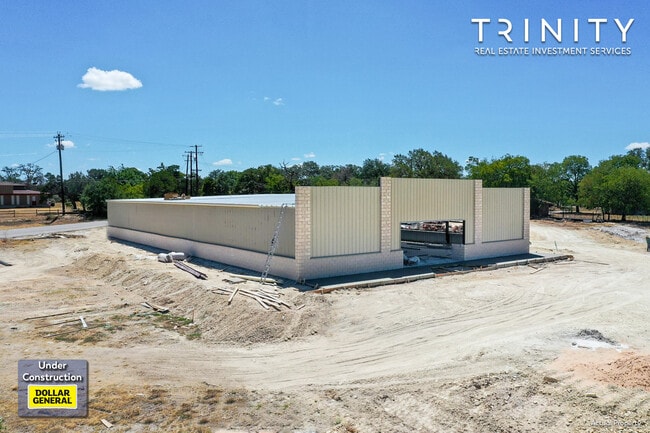
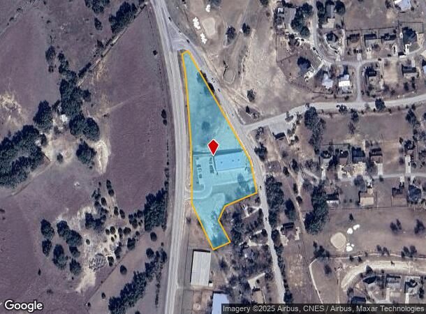
1245 State Highway 173 N
San Antonio-New Braunfels, TX
Bandera 173 Dg Addition
165919
BANDERA 173 DG ADDITION BLK 1 LT 1 2.173 ACRES
Officebuilding
Bandera
X
Texas
48019C0385F
1
0
2.17 AC
2025
Bandera County
000103
San Antonio
10,966 SF
DEMOGRAPHICS near 1245 State Highway 173 N
1 Mile
3 Mile
5 Mile
2024 Total Population
1,021
3,850
6,865
2029 Population
1,189
4,434
7,932
Pop Growth 2024-2029
+ 16.45%
+ 15.17%
+ 15.54%
Average Age
51
49
49
2024 Total Households
429
1,687
2,905
HH Growth 2024-2029
+ 16.08%
+ 14.70%
+ 15.04%
Median Household Inc
$73,124
$60,951
$62,662
Avg Household Size
2.30
2.20
2.30
2024 Avg HH Vehicles
2.00
2.00
2.00
Median Home Value
$370,930
$264,638
$265,008
Median Year Built
1998
1993
1997
Nearby Places
Map Layers
Map Styles
 Street
 Aerial
- Restaurants
- Banks
- Shops
- Fitness
- Groceries
PUBLIC TRANSPORTATION
AIRPORT
San Antonio International
DRIVE
WALK
Distance
San Antonio International
65 min
48.0 mi
SALE & LEASE HISTORY
LISTING DATE
SALE/LEASE

Aug 05, 2022
For Sale
Nearby Properties
Address
Land Use
TOTAL SIZE
Lot Size
Zoning
Address
Land Use
TOTAL SIZE
Lot Size
Zoning
192,637 SF
53.96 AC
Address
Land Use
TOTAL SIZE
Lot Size
Zoning
6,144 SF
27.59 AC
Address
Land Use
TOTAL SIZE
Lot Size
Zoning
81,182 SF
3 AC
Address
Land Use
TOTAL SIZE
Lot Size
Zoning
33,040 SF
0.73 AC
Address
Land Use
TOTAL SIZE
Lot Size
Zoning
54,228 SF
0.96 AC
Address
Land Use
TOTAL SIZE
Lot Size
Zoning
39,842 SF
3.67 AC
Address
Land Use
TOTAL SIZE
Lot Size
Zoning
8,612 SF
1.43 AC
Address
Land Use
TOTAL SIZE
Lot Size
Zoning
12,803 SF
8 AC
Address
Land Use
TOTAL SIZE
Lot Size
Zoning
1,955 SF
8.26 AC
Address
Land Use
TOTAL SIZE
Lot Size
Zoning
4,854 SF
4 AC
Address
Land Use
TOTAL SIZE
Lot Size
Zoning
15,494 SF
2.55 AC
Address
Land Use
TOTAL SIZE
Lot Size
Zoning
3,594 SF
7.54 AC
Address
Land Use
TOTAL SIZE
Lot Size
Zoning
134.08 AC
Address
Land Use
TOTAL SIZE
Lot Size
Zoning
1,900 SF
6.24 AC
Address
Land Use
TOTAL SIZE
Lot Size
Zoning
760 SF
32.25 AC
Address
Land Use
TOTAL SIZE
Lot Size
Zoning
21,826 SF
3 AC
Address
Land Use
TOTAL SIZE
Lot Size
Zoning
28,063 SF
2.55 AC
Address
Land Use
TOTAL SIZE
Lot Size
Zoning
18,130 SF
4.07 AC
Address
Land Use
TOTAL SIZE
Lot Size
Zoning
4,148 SF
1.27 AC
Address
Land Use
TOTAL SIZE
Lot Size
Zoning
3,051 SF
5 AC
Address
Land Use
TOTAL SIZE
Lot Size
Zoning
6,000 SF
3.77 AC
Address
Land Use
TOTAL SIZE
Lot Size
Zoning
18,900 SF
3.81 AC
Address
Land Use
TOTAL SIZE
Lot Size
Zoning
9,120 SF
0.96 AC
Address
Land Use
TOTAL SIZE
Lot Size
Zoning
12,915 SF
0.96 AC
Address
Land Use
TOTAL SIZE
Lot Size
Zoning
15.30 AC
Address
Land Use
TOTAL SIZE
Lot Size
Zoning
10,647 SF
2.85 AC
Address
Land Use
TOTAL SIZE
Lot Size
Zoning
12,528 SF
2.56 AC
Address
Land Use
TOTAL SIZE
Lot Size
Zoning
153.01 AC
Address
Land Use
TOTAL SIZE
Lot Size
Zoning
12,302 SF
3.81 AC
Address
Land Use
TOTAL SIZE
Lot Size
Zoning
14,140 SF
2.60 AC
The World's #1 Commercial Real Estate Marketplace
Connect with us
© 2026 CoStar Group
The information above has been obtained from sources believed reliable. While we do not doubt its accuracy we have not verified it and make no guarantee, warranty or representation about it. It is your responsibility to independently confirm its accuracy and completeness. Any projections, opinions, assumptions, or estimates used are for example only and do not represent the current or future performance of the property. The value of this transaction to you depends on tax and other factors which should be evaluated by your tax, financial, and legal advisors. You and your advisors should conduct a careful, independent investigation of the property to determine to your satisfaction the suitability of the property for your needs.