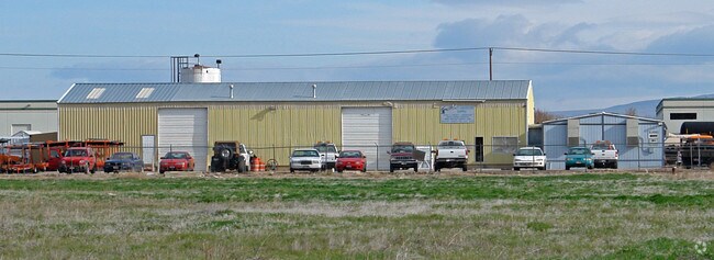
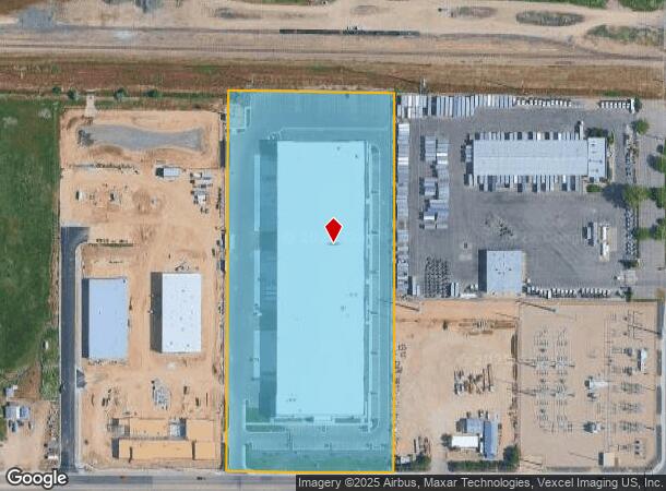
Property Record
12450 W Franklin Rd, Boise, ID 83709
NEARBY LISTINGS FOR SALE OR LEASE
Property Detail
12450 W Franklin Rd
S1109449000
Subd Code: 1109449
Commercialbuilding
PAR #9030 POR SE4SE4 SEC 9 3N 1E PARCEL A ROS 13057 #449000-C #449025-C #449045-C
X
Ada
16001C0252G
Idaho
2024
9.82 AC
2025
Meridian
010370
Boise City/Nampa
166,184 SF
Boise City, ID
DEMOGRAPHICS near 12450 W Franklin Rd
1 Mile
3 Mile
5 Mile
2024 Total Population
7,110
96,952
258,077
2029 Population
8,033
109,592
292,187
Pop Growth 2024-2029
+ 12.98%
+ 13.04%
+ 13.22%
Average Age
43
40
40
2024 Total Households
2,791
36,704
96,257
HH Growth 2024-2029
+ 13.29%
+ 13.37%
+ 13.50%
Median Household Inc
$83,504
$74,593
$77,764
Avg Household Size
2.40
2.60
2.60
2024 Avg HH Vehicles
2.00
2.00
2.00
Median Home Value
$378,716
$423,740
$429,156
Median Year Built
1996
1996
1997
Nearby Places
Map Layers
Map Styles
 Street
 Aerial
- Restaurants
- Banks
- Shops
- Fitness
- Groceries
PUBLIC TRANSPORTATION
AIRPORT
Boise Air Trml/Gowen Field
DRIVE
WALK
Distance
Boise Air Trml/Gowen Field
19 min
11.0 mi
Nearby Properties
Address
Land Use
TOTAL SIZE
Lot Size
Zoning
Address
Land Use
TOTAL SIZE
Lot Size
Zoning
533,727 SF
22.89 AC
C-G
Address
Land Use
TOTAL SIZE
Lot Size
Zoning
646,787 SF
27.37 AC
ZC-243
Address
Land Use
TOTAL SIZE
Lot Size
Zoning
789,114 SF
11.38 AC
C-G
Address
Land Use
TOTAL SIZE
Lot Size
Zoning
505,966 SF
51.08 AC
L-O
Address
Land Use
TOTAL SIZE
Lot Size
Zoning
334,124 SF
11.21 AC
R-3
Address
Land Use
TOTAL SIZE
Lot Size
Zoning
245,810 SF
11.19 AC
R-40
Address
Land Use
TOTAL SIZE
Lot Size
Zoning
269,509 SF
12 AC
R-40
Address
Land Use
TOTAL SIZE
Lot Size
Zoning
413,805 SF
15.64 AC
C-G
Address
Land Use
TOTAL SIZE
Lot Size
Zoning
335,459 SF
11.23 AC
R-40
Address
Land Use
TOTAL SIZE
Lot Size
Zoning
243,949 SF
13.81 AC
R-40
Address
Land Use
TOTAL SIZE
Lot Size
Zoning
305,889 SF
9.91 AC
R-40
Address
Land Use
TOTAL SIZE
Lot Size
Zoning
310,580 SF
2.44 AC
C-G
Address
Land Use
TOTAL SIZE
Lot Size
Zoning
171,454 SF
10.66 AC
C-G
Address
Land Use
TOTAL SIZE
Lot Size
Zoning
203,377 SF
21.13 AC
C-G
Address
Land Use
TOTAL SIZE
Lot Size
Zoning
230,810 SF
20.09 AC
C-G
Address
Land Use
TOTAL SIZE
Lot Size
Zoning
150,000 SF
5.44 AC
C-G
Address
Land Use
TOTAL SIZE
Lot Size
Zoning
249,800 SF
12.99 AC
ZC-243
Address
Land Use
TOTAL SIZE
Lot Size
Zoning
147,239 SF
7.56 AC
C-G
Address
Land Use
TOTAL SIZE
Lot Size
Zoning
319,052 SF
24.33 AC
ZC-243
Address
Land Use
TOTAL SIZE
Lot Size
Zoning
238,300 SF
34.70 AC
I-L
Address
Land Use
TOTAL SIZE
Lot Size
Zoning
167,416 SF
18.57 AC
C-G
Address
Land Use
TOTAL SIZE
Lot Size
Zoning
125,362 SF
7.08 AC
C-G
Address
Land Use
TOTAL SIZE
Lot Size
Zoning
176,788 SF
16.07 AC
C-G
Address
Land Use
TOTAL SIZE
Lot Size
Zoning
211,460 SF
11.75 AC
C-G
Address
Land Use
TOTAL SIZE
Lot Size
Zoning
162,432 SF
8.31 AC
R-3
Address
Land Use
TOTAL SIZE
Lot Size
Zoning
72,579 SF
4.48 AC
ZC-269
Address
Land Use
TOTAL SIZE
Lot Size
Zoning
207,060 SF
9.88 AC
I-L
Address
Land Use
TOTAL SIZE
Lot Size
Zoning
184,577 SF
11.39 AC
C-G
Address
Land Use
TOTAL SIZE
Lot Size
Zoning
85,483 SF
2.42 AC
C-G
Address
Land Use
TOTAL SIZE
Lot Size
Zoning
118,953 SF
4.37 AC
C-G
The World's #1 Commercial Real Estate Marketplace
Connect with us
© 2026 CoStar Group
The information above has been obtained from sources believed reliable. While we do not doubt its accuracy we have not verified it and make no guarantee, warranty or representation about it. It is your responsibility to independently confirm its accuracy and completeness. Any projections, opinions, assumptions, or estimates used are for example only and do not represent the current or future performance of the property. The value of this transaction to you depends on tax and other factors which should be evaluated by your tax, financial, and legal advisors. You and your advisors should conduct a careful, independent investigation of the property to determine to your satisfaction the suitability of the property for your needs.