Property Record
12454 Browns Berry Rd, Dover, FL 33527
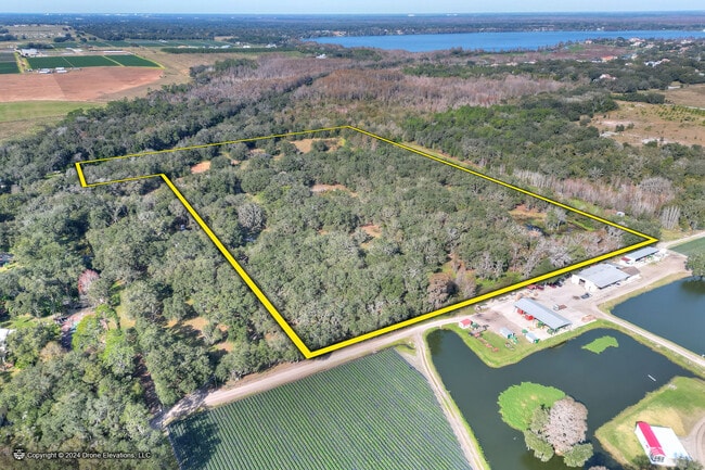
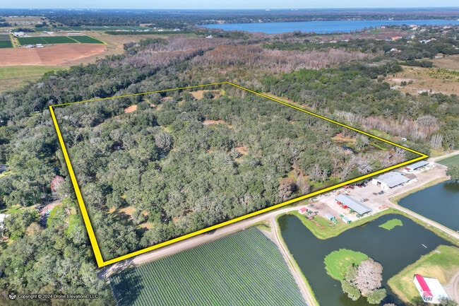
This Property Is For Sale
NEARBY LISTINGS FOR SALE OR LEASE
Property Detail
12454 Browns Berry Rd
Tampa-St. Petersburg-Clearwater, FL
Unplatted
U-13-28-20-ZZZ-000002-03110.0
SW 1/4 OF SE 1/4 LESS N 330 FT THEREOF AND LESS THE S 208.75 FT OF THE E 1043.55 FT OF THE SW 1/4 OF SE 1/4
Sfr
Hillsborough
AE
Florida
12057C0242H
3110
2024
25.26 AC
2024
Northeast Tampa
010304
Tampa/St Petersburg
2,872 SF
DEMOGRAPHICS near 12454 Browns Berry Rd
1 Mile
3 Mile
5 Mile
2024 Total Population
1,342
15,744
58,098
2029 Population
1,477
17,230
63,595
Pop Growth 2024-2029
+ 10.06%
+ 9.44%
+ 9.46%
Average Age
44
42
40
2024 Total Households
497
5,675
20,342
HH Growth 2024-2029
+ 10.26%
+ 9.66%
+ 9.73%
Median Household Inc
$71,694
$71,097
$61,824
Avg Household Size
2.60
2.70
2.70
2024 Avg HH Vehicles
2.00
2.00
2.00
Median Home Value
$337,349
$318,078
$279,960
Median Year Built
1987
1987
1987
Nearby Places
- Restaurants
- Banks
- Shops
- Fitness
- Groceries
PUBLIC TRANSPORTATION
AIRPORT
Tampa International
DRIVE
WALK
Distance
Tampa International
36 min
24.4 mi
St Pete-Clearwater International
DRIVE
WALK
Distance
St Pete-Clearwater International
53 min
33.6 mi
Freight Ports
Port of Tampa Bay
DRIVE
WALK
Distance
Port of Tampa Bay
29 min
17.8 mi
Nearby Properties
Address
Land Use
TOTAL SIZE
Lot Size
Zoning
Address
Land Use
TOTAL SIZE
Lot Size
Zoning
319,392 SF
105.53 AC
AR
Address
Land Use
TOTAL SIZE
Lot Size
Zoning
165,277 SF
27.50 AC
AR
Address
Land Use
TOTAL SIZE
Lot Size
Zoning
55,668 SF
63.68 AC
PD
Address
Land Use
TOTAL SIZE
Lot Size
Zoning
34,385 SF
27.96 AC
PD
Address
Land Use
TOTAL SIZE
Lot Size
Zoning
31,854 SF
26.89 AC
PD
Address
Land Use
TOTAL SIZE
Lot Size
Zoning
61,585 SF
12.98 AC
AI
Address
Land Use
TOTAL SIZE
Lot Size
Zoning
25,055 SF
70.22 AC
PD
Address
Land Use
TOTAL SIZE
Lot Size
Zoning
28,112 SF
13.93 AC
ASC-1
Address
Land Use
TOTAL SIZE
Lot Size
Zoning
6,448 SF
31.68 AC
PD
Address
Land Use
TOTAL SIZE
Lot Size
Zoning
30,055 SF
9.52 AC
AR
Address
Land Use
TOTAL SIZE
Lot Size
Zoning
14,857 SF
24.67 AC
AR
Address
Land Use
TOTAL SIZE
Lot Size
Zoning
67,929 SF
14.46 AC
AR
Address
Land Use
TOTAL SIZE
Lot Size
Zoning
42,289 SF
5.10 AC
PD
Address
Land Use
TOTAL SIZE
Lot Size
Zoning
40,799 SF
4.35 AC
AS-1
Address
Land Use
TOTAL SIZE
Lot Size
Zoning
8,336 SF
8.13 AC
ASC-1
Address
Land Use
TOTAL SIZE
Lot Size
Zoning
18,000 SF
4.07 AC
CG
Address
Land Use
TOTAL SIZE
Lot Size
Zoning
24,314 SF
7.55 AC
AS-1
Address
Land Use
TOTAL SIZE
Lot Size
Zoning
20,493 SF
79.78 AC
AS-1
Address
Land Use
TOTAL SIZE
Lot Size
Zoning
6,278 SF
1.98 AC
CG
Address
Land Use
TOTAL SIZE
Lot Size
Zoning
14.47 AC
PD
Address
Land Use
TOTAL SIZE
Lot Size
Zoning
6,068 SF
26.51 AC
AR
Address
Land Use
TOTAL SIZE
Lot Size
Zoning
17,819 SF
33.32 AC
AR
Address
Land Use
TOTAL SIZE
Lot Size
Zoning
13,828 SF
0.52 AC
CG
Address
Land Use
TOTAL SIZE
Lot Size
Zoning
5,636 SF
1.65 AC
CN
Address
Land Use
TOTAL SIZE
Lot Size
Zoning
6,642 SF
20.28 AC
ASC-1
Address
Land Use
TOTAL SIZE
Lot Size
Zoning
6,068 SF
25.05 AC
AS-1
Address
Land Use
TOTAL SIZE
Lot Size
Zoning
14,168 SF
2.22 AC
CG
Address
Land Use
TOTAL SIZE
Lot Size
Zoning
25,587 SF
40.50 AC
AR
Address
Land Use
TOTAL SIZE
Lot Size
Zoning
7,564 SF
2.54 AC
PD
The World's #1 Commercial Real Estate Marketplace
Connect with us
© 2025 CoStar Group
The information above has been obtained from sources believed reliable. While we do not doubt its accuracy we have not verified it and make no guarantee, warranty or representation about it. It is your responsibility to independently confirm its accuracy and completeness. Any projections, opinions, assumptions, or estimates used are for example only and do not represent the current or future performance of the property. The value of this transaction to you depends on tax and other factors which should be evaluated by your tax, financial, and legal advisors. You and your advisors should conduct a careful, independent investigation of the property to determine to your satisfaction the suitability of the property for your needs.