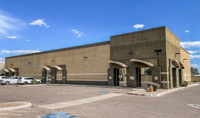
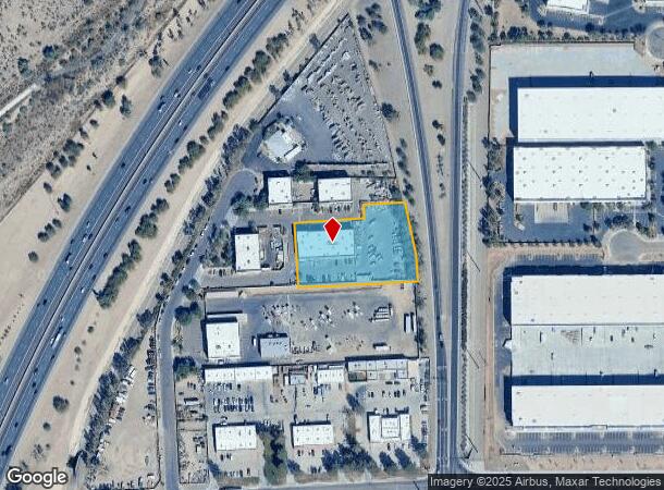
Property Record
12455 N 92Nd Dr, Peoria, AZ 85381
Current Lease Availabilities
NEARBY LISTINGS FOR SALE OR LEASE
Property Detail
12455 N 92Nd Dr
Phoenix-Mesa-Scottsdale, AZ
Cactus Heights Industrial Park Replat 2
200-87-772
CACTUS HEIGHTS INDUSTRIAL PARK REPLAT 2 REPLAT MCR 1241-46
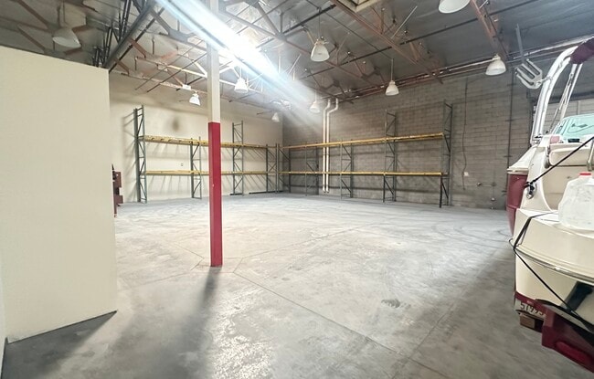
Warehouse
Maricopa
X
Arizona
04013C1685M
3a
2025
1.71 AC
2025
Surprise
071517
Phoenix
13,600 SF
DEMOGRAPHICS near 12455 N 92Nd Dr
1 Mile
3 Mile
5 Mile
2024 Total Population
14,523
113,209
305,567
2029 Population
15,623
122,547
330,836
Pop Growth 2024-2029
+ 7.57%
+ 8.25%
+ 8.27%
Average Age
43
48
43
2024 Total Households
6,141
48,957
120,767
HH Growth 2024-2029
+ 7.73%
+ 8.47%
+ 8.48%
Median Household Inc
$58,938
$57,786
$62,442
Avg Household Size
2.20
2.20
2.40
2024 Avg HH Vehicles
2.00
2.00
2.00
Median Home Value
$276,826
$273,677
$289,283
Median Year Built
1990
1981
1987
Nearby Places
- Restaurants
- Banks
- Shops
- Fitness
- Groceries
PUBLIC TRANSPORTATION
AIRPORT
Phoenix Sky Harbor International
DRIVE
WALK
Distance
Phoenix Sky Harbor International
37 min
21.1 mi
Phoenix-Mesa Gateway
DRIVE
WALK
Distance
Phoenix-Mesa Gateway
70 min
48.3 mi
Nearby Properties
Address
Land Use
TOTAL SIZE
Lot Size
Zoning
Address
Land Use
TOTAL SIZE
Lot Size
Zoning
81,100 SF
9.48 AC
PAD
Address
Land Use
TOTAL SIZE
Lot Size
Zoning
1,010,365 SF
29.94 AC
C2
Address
Land Use
TOTAL SIZE
Lot Size
Zoning
238,942 SF
36.87 AC
R1-8
Address
Land Use
TOTAL SIZE
Lot Size
Zoning
926 SF
37.32 AC
I-1
Address
Land Use
TOTAL SIZE
Lot Size
Zoning
1,113,127 SF
48.24 AC
C2
Address
Land Use
TOTAL SIZE
Lot Size
Zoning
359,639 SF
16.29 AC
PAD
Address
Land Use
TOTAL SIZE
Lot Size
Zoning
303,051 SF
9.11 AC
AG
Address
Land Use
TOTAL SIZE
Lot Size
Zoning
307,822 SF
26.49 AC
PAD
Address
Land Use
TOTAL SIZE
Lot Size
Zoning
547,083 SF
10.94 AC
C-C
Address
Land Use
TOTAL SIZE
Lot Size
Zoning
353,859 SF
11.71 AC
PAD
Address
Land Use
TOTAL SIZE
Lot Size
Zoning
366,400 SF
19.99 AC
PAD
Address
Land Use
TOTAL SIZE
Lot Size
Zoning
318,282 SF
15.23 AC
PAD
Address
Land Use
TOTAL SIZE
Lot Size
Zoning
325,529 SF
10.85 AC
PAD
Address
Land Use
TOTAL SIZE
Lot Size
Zoning
20,948 SF
2.39 AC
R-6
Address
Land Use
TOTAL SIZE
Lot Size
Zoning
115,027 SF
14.46 AC
R-8
Address
Land Use
TOTAL SIZE
Lot Size
Zoning
150,002 SF
10.91 AC
C-C
Address
Land Use
TOTAL SIZE
Lot Size
Zoning
319,723 SF
10.79 AC
PAD
Address
Land Use
TOTAL SIZE
Lot Size
Zoning
86,343 SF
13.52 AC
M-M
Address
Land Use
TOTAL SIZE
Lot Size
Zoning
210,605 SF
6.76 AC
PAD
Address
Land Use
TOTAL SIZE
Lot Size
Zoning
163,814 SF
15.31 AC
PAD
Address
Land Use
TOTAL SIZE
Lot Size
Zoning
82,688 SF
18.70 AC
PAD
Address
Land Use
TOTAL SIZE
Lot Size
Zoning
230,076 SF
14.03 AC
PAD
Address
Land Use
TOTAL SIZE
Lot Size
Zoning
301,213 SF
18.86 AC
PAD
Address
Land Use
TOTAL SIZE
Lot Size
Zoning
126,841 SF
20.59 AC
PAD
Address
Land Use
TOTAL SIZE
Lot Size
Zoning
262,295 SF
14.79 AC
M-M
Address
Land Use
TOTAL SIZE
Lot Size
Zoning
88,793 SF
13.41 AC
R-8
Address
Land Use
TOTAL SIZE
Lot Size
Zoning
9.40 AC
Address
Land Use
TOTAL SIZE
Lot Size
Zoning
70,373 SF
22.65 AC
Address
Land Use
TOTAL SIZE
Lot Size
Zoning
278,764 SF
15.13 AC
PAD
Address
Land Use
TOTAL SIZE
Lot Size
Zoning
65,825 SF
10.26 AC
PAD
The World's #1 Commercial Real Estate Marketplace
Connect with us
© 2025 CoStar Group
The information above has been obtained from sources believed reliable. While we do not doubt its accuracy we have not verified it and make no guarantee, warranty or representation about it. It is your responsibility to independently confirm its accuracy and completeness. Any projections, opinions, assumptions, or estimates used are for example only and do not represent the current or future performance of the property. The value of this transaction to you depends on tax and other factors which should be evaluated by your tax, financial, and legal advisors. You and your advisors should conduct a careful, independent investigation of the property to determine to your satisfaction the suitability of the property for your needs.