Property Record
12461 Union Grove Church Rd, Calhoun, GA 30701
This Property Is For Sale
NEARBY LISTINGS FOR SALE OR LEASE
Property Detail
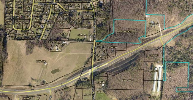
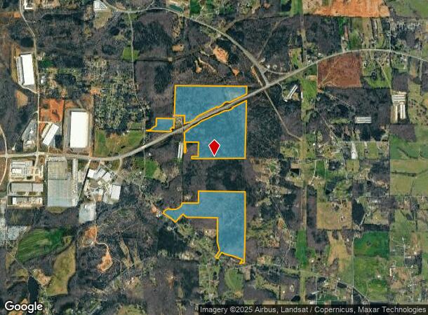
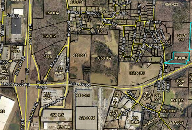
12461 Union Grove Church Rd
Calhoun, GA
Lang Est
058-062
TR 1 & 2 OF LANG EST
Agriculturalland
Gordon
X
Georgia
13015C0050H
2
2024
205.96 AC
2024
Georgia Northwest
970500
Other Market Areas
DEMOGRAPHICS near 12461 Union Grove Church Rd
1 Mile
3 Mile
5 Mile
2024 Total Population
581
6,475
26,339
2029 Population
634
6,992
28,136
Pop Growth 2024-2029
+ 9.12%
+ 7.98%
+ 6.82%
Average Age
41
40
39
2024 Total Households
224
2,381
9,640
HH Growth 2024-2029
+ 8.48%
+ 7.98%
+ 6.63%
Median Household Inc
$42,666
$50,629
$56,792
Avg Household Size
2.60
2.70
2.70
2024 Avg HH Vehicles
2.00
2.00
2.00
Median Home Value
$160,869
$172,329
$197,839
Median Year Built
2001
1990
1989
Nearby Places
- Restaurants
- Banks
- Shops
- Fitness
- Groceries
Nearby Properties
Address
Land Use
TOTAL SIZE
Lot Size
Zoning
Address
Land Use
TOTAL SIZE
Lot Size
Zoning
740,998 SF
55.39 AC
IND-G
Address
Land Use
TOTAL SIZE
Lot Size
Zoning
445,290 SF
37.89 AC
I-2
Address
Land Use
TOTAL SIZE
Lot Size
Zoning
403,152 SF
8.33 AC
Address
Land Use
TOTAL SIZE
Lot Size
Zoning
740,750 SF
30.22 AC
IND-G
Address
Land Use
TOTAL SIZE
Lot Size
Zoning
474,912 SF
54.83 AC
IND-G
Address
Land Use
TOTAL SIZE
Lot Size
Zoning
408,600 SF
38.92 AC
I-2
Address
Land Use
TOTAL SIZE
Lot Size
Zoning
549,997 SF
138.47 AC
IND-G
Address
Land Use
TOTAL SIZE
Lot Size
Zoning
454,680 SF
5.23 AC
IND-G
Address
Land Use
TOTAL SIZE
Lot Size
Zoning
89,298 SF
25.68 AC
I-2
Address
Land Use
TOTAL SIZE
Lot Size
Zoning
860,400 SF
19.85 AC
IND-G
Address
Land Use
TOTAL SIZE
Lot Size
Zoning
96,647 SF
35.06 AC
I-2
Address
Land Use
TOTAL SIZE
Lot Size
Zoning
2,870 SF
11.02 AC
PRD
Address
Land Use
TOTAL SIZE
Lot Size
Zoning
50,676 SF
19.74 AC
C-2
Address
Land Use
TOTAL SIZE
Lot Size
Zoning
2,899 SF
12 AC
Address
Land Use
TOTAL SIZE
Lot Size
Zoning
3,360 SF
25.27 AC
RC-1
Address
Land Use
TOTAL SIZE
Lot Size
Zoning
6,956 SF
7 AC
R-2
Address
Land Use
TOTAL SIZE
Lot Size
Zoning
281,810 SF
22.74 AC
IND-G
Address
Land Use
TOTAL SIZE
Lot Size
Zoning
207,900 SF
13.43 AC
IND-G
Address
Land Use
TOTAL SIZE
Lot Size
Zoning
225,000 SF
14.68 AC
IND-G
Address
Land Use
TOTAL SIZE
Lot Size
Zoning
16,424 SF
5.73 AC
MU
Address
Land Use
TOTAL SIZE
Lot Size
Zoning
67,800 SF
10.53 AC
I-1
Address
Land Use
TOTAL SIZE
Lot Size
Zoning
259,964 SF
78.21 AC
IND-G
Address
Land Use
TOTAL SIZE
Lot Size
Zoning
422,500 SF
86.37 AC
I-1
Address
Land Use
TOTAL SIZE
Lot Size
Zoning
161,958 SF
14.99 AC
C-2
Address
Land Use
TOTAL SIZE
Lot Size
Zoning
455,554 SF
19.79 AC
IND-G
Address
Land Use
TOTAL SIZE
Lot Size
Zoning
15,144 SF
19.26 AC
A-1
Address
Land Use
TOTAL SIZE
Lot Size
Zoning
498,811 SF
60.43 AC
IND-G
Address
Land Use
TOTAL SIZE
Lot Size
Zoning
116,986 SF
Address
Land Use
TOTAL SIZE
Lot Size
Zoning
99,360 SF
5.24 AC
IND-G
Address
Land Use
TOTAL SIZE
Lot Size
Zoning
41,333 SF
2.50 AC
C-2
The World's #1 Commercial Real Estate Marketplace
Connect with us
© 2025 CoStar Group
The information above has been obtained from sources believed reliable. While we do not doubt its accuracy we have not verified it and make no guarantee, warranty or representation about it. It is your responsibility to independently confirm its accuracy and completeness. Any projections, opinions, assumptions, or estimates used are for example only and do not represent the current or future performance of the property. The value of this transaction to you depends on tax and other factors which should be evaluated by your tax, financial, and legal advisors. You and your advisors should conduct a careful, independent investigation of the property to determine to your satisfaction the suitability of the property for your needs.