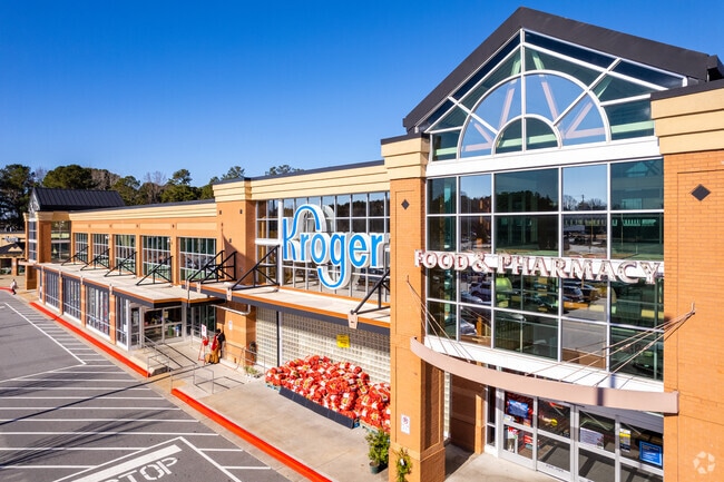
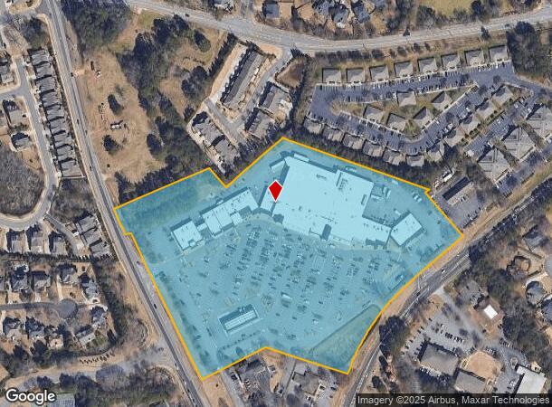
Property Record
12465 Crabapple Rd, Alpharetta, GA 30004
NEARBY LISTINGS FOR SALE OR LEASE
Property Detail
12465 Crabapple Rd
22-3860-1166-043-5
4
Regionalshoppingcenterormallwithanchorstore
Fulton
X
Georgia
13121C0053G
4
2024
14.70 AC
2025
Roswell/Alpharetta
011510
Atlanta
154,764 SF
Atlanta-Sandy Springs-Roswell, GA
DEMOGRAPHICS near 12465 Crabapple Rd
1 Mile
3 Mile
5 Mile
2024 Total Population
7,995
40,870
120,475
2029 Population
8,070
41,716
124,456
Pop Growth 2024-2029
+ 0.94%
+ 2.07%
+ 3.30%
Average Age
40
41
40
2024 Total Households
2,739
14,648
45,245
HH Growth 2024-2029
+ 0.99%
+ 2.21%
+ 3.49%
Median Household Inc
$155,142
$154,125
$133,096
Avg Household Size
2.90
2.70
2.60
2024 Avg HH Vehicles
2.00
2.00
2.00
Median Home Value
$531,128
$495,497
$491,757
Median Year Built
1995
1993
1993
Nearby Places
Map Layers
Map Styles
 Street
 Aerial
- Restaurants
- Banks
- Shops
- Fitness
- Groceries
SALE & LEASE HISTORY
LISTING DATE
SALE/LEASE

Sep 24, 2016
For Lease
Nearby Properties
Address
Land Use
TOTAL SIZE
Lot Size
Zoning
Address
Land Use
TOTAL SIZE
Lot Size
Zoning
3,459,339 SF
26.51 AC
OI
Address
Land Use
TOTAL SIZE
Lot Size
Zoning
11.82 AC
Address
Land Use
TOTAL SIZE
Lot Size
Zoning
260,648 SF
34.20 AC
C3C
Address
Land Use
TOTAL SIZE
Lot Size
Zoning
2,674,992 SF
28.94 AC
R4C
Address
Land Use
TOTAL SIZE
Lot Size
Zoning
2,289 SF
84.27 AC
AG1
Address
Land Use
TOTAL SIZE
Lot Size
Zoning
264,255 SF
51 AC
E2
Address
Land Use
TOTAL SIZE
Lot Size
Zoning
306,753 SF
19.77 AC
HMS
Address
Land Use
TOTAL SIZE
Lot Size
Zoning
71,000 SF
48.73 AC
E1
Address
Land Use
TOTAL SIZE
Lot Size
Zoning
3,727,094 SF
5.92 AC
OI
Address
Land Use
TOTAL SIZE
Lot Size
Zoning
179,182 SF
15.06 AC
OI
Address
Land Use
TOTAL SIZE
Lot Size
Zoning
377,080 SF
19.37 AC
E1
Address
Land Use
TOTAL SIZE
Lot Size
Zoning
52,148 SF
6.99 AC
C1
Address
Land Use
TOTAL SIZE
Lot Size
Zoning
299,502 SF
19.77 AC
E2
Address
Land Use
TOTAL SIZE
Lot Size
Zoning
1,199,716 SF
7.10 AC
C1
Address
Land Use
TOTAL SIZE
Lot Size
Zoning
46.70 AC
R1
Address
Land Use
TOTAL SIZE
Lot Size
Zoning
180,336 SF
14.59 AC
R1
Address
Land Use
TOTAL SIZE
Lot Size
Zoning
236,370 SF
27.52 AC
R5
Address
Land Use
TOTAL SIZE
Lot Size
Zoning
32.02 AC
Address
Land Use
TOTAL SIZE
Lot Size
Zoning
95,478 SF
3 AC
Address
Land Use
TOTAL SIZE
Lot Size
Zoning
183,216 SF
15.02 AC
C3C
Address
Land Use
TOTAL SIZE
Lot Size
Zoning
1,175 SF
40.66 AC
AG1
Address
Land Use
TOTAL SIZE
Lot Size
Zoning
75,560 SF
10.32 AC
E2
Address
Land Use
TOTAL SIZE
Lot Size
Zoning
185,520 SF
23.28 AC
AG1
Address
Land Use
TOTAL SIZE
Lot Size
Zoning
25.90 AC
E2
Address
Land Use
TOTAL SIZE
Lot Size
Zoning
173,529 SF
19.80 AC
OI
Address
Land Use
TOTAL SIZE
Lot Size
Zoning
28.08 AC
E2
Address
Land Use
TOTAL SIZE
Lot Size
Zoning
25.40 AC
E1
Address
Land Use
TOTAL SIZE
Lot Size
Zoning
100,696 SF
9.96 AC
E2
Address
Land Use
TOTAL SIZE
Lot Size
Zoning
405,500 SF
6 AC
OI
The World's #1 Commercial Real Estate Marketplace
Connect with us
© 2026 CoStar Group
The information above has been obtained from sources believed reliable. While we do not doubt its accuracy we have not verified it and make no guarantee, warranty or representation about it. It is your responsibility to independently confirm its accuracy and completeness. Any projections, opinions, assumptions, or estimates used are for example only and do not represent the current or future performance of the property. The value of this transaction to you depends on tax and other factors which should be evaluated by your tax, financial, and legal advisors. You and your advisors should conduct a careful, independent investigation of the property to determine to your satisfaction the suitability of the property for your needs.