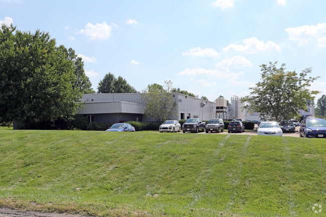
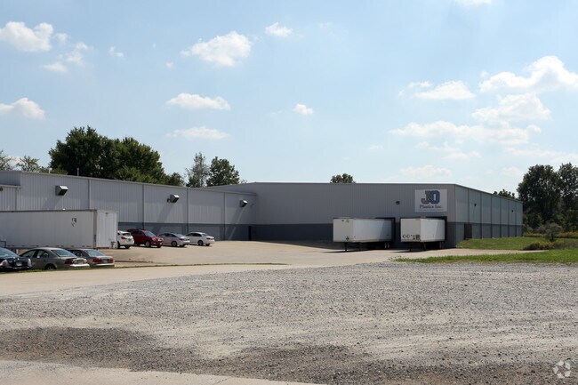
Property Record
12475 Sheets Rd, Rittman, OH 44270

Property Detail
12475 Sheets Rd
60-00021-001
LOT 2848 SIMPSON ALT 1 6.423A MP 50 ST VAC CD 3031
Manufacturinglight
Wayne
M3
Ohio
C and X Area of minimal flood hazard, usually depicted on FIRMs as above the 500-year flood level.
2848
2025
6.42 AC
2025
Ohio North Area
002902
Other Market Areas
31,800 SF
Wooster, OH
NEARBY LISTINGS FOR SALE OR LEASE
DEMOGRAPHICS near 12475 Sheets Rd
1 mile
3 mile
5 mile
2025 Total Population
532
12,203
38,173
2030 Population
532
12,323
38,390
Pop Growth 2025-2030
0.00%
+ 0.98%
+ 0.57%
Average Age
44
42
41
2025 Total Households
206
4,876
15,124
HH Growth 2025-2030
0.00%
+ 0.94%
+ 0.53%
Median Household Inc
$83,984
$67,331
$72,072
Avg Household Size
2.50
2.40
2.50
2025 Avg HH Vehicles
3.00
2.00
2.00
Median Home Value
$261,111
$201,143
$228,658
Median Year Built
1982
1971
1971
Nearby Places
Map Layers
Map Styles
 Street
 Aerial
Layers
 Traffic
 Biking
Places
Listings with unknown addresses are not visible on the map
- Restaurants
- Banks
- Shops
- Fitness
- Groceries
PUBLIC TRANSPORTATION
AIRPORT
Akron-Canton Regional
Drive
Walk
Distance
Akron-Canton Regional
37 min
28.5 mi
Freight Ports
Port of Toledo
Drive
Walk
Distance
Port of Toledo
166 min
132.9 mi
Nearby Properties
Address
Land Use
TOTAL SIZE
Lot Size
Zoning
Address
Land Use
TOTAL SIZE
Lot Size
Zoning
41,363 SF
43.52 AC
PSM
Address
Land Use
TOTAL SIZE
Lot Size
Zoning
2,626 SF
12.89 AC
Address
Land Use
TOTAL SIZE
Lot Size
Zoning
38,794 SF
40 AC
Address
Land Use
TOTAL SIZE
Lot Size
Zoning
51,416 SF
15.13 AC
Address
Land Use
TOTAL SIZE
Lot Size
Zoning
6,573 SF
22.01 AC
Address
Land Use
TOTAL SIZE
Lot Size
Zoning
37,843 SF
5.82 AC
Address
Land Use
TOTAL SIZE
Lot Size
Zoning
90,267 SF
10.91 AC
Address
Land Use
TOTAL SIZE
Lot Size
Zoning
66,384 SF
28.30 AC
Address
Land Use
TOTAL SIZE
Lot Size
Zoning
106,929 SF
13.79 AC
Address
Land Use
TOTAL SIZE
Lot Size
Zoning
126,672 SF
12.27 AC
Address
Land Use
TOTAL SIZE
Lot Size
Zoning
184,090 SF
22.64 AC
Address
Land Use
TOTAL SIZE
Lot Size
Zoning
18,743 SF
7.01 AC
Address
Land Use
TOTAL SIZE
Lot Size
Zoning
16,722 SF
18.17 AC
Address
Land Use
TOTAL SIZE
Lot Size
Zoning
20,767 SF
9.35 AC
Address
Land Use
TOTAL SIZE
Lot Size
Zoning
53,642 SF
7.71 AC
Address
Land Use
TOTAL SIZE
Lot Size
Zoning
31,075 SF
3.17 AC
PSM
Address
Land Use
TOTAL SIZE
Lot Size
Zoning
14.21 AC
Address
Land Use
TOTAL SIZE
Lot Size
Zoning
45,337 SF
11.59 AC
Address
Land Use
TOTAL SIZE
Lot Size
Zoning
13,980 SF
2.91 AC
PSM
Address
Land Use
TOTAL SIZE
Lot Size
Zoning
5,880 SF
4.84 AC
Address
Land Use
TOTAL SIZE
Lot Size
Zoning
2,760 SF
19.01 AC
Address
Land Use
TOTAL SIZE
Lot Size
Zoning
20,000 SF
3.60 AC
M3
Address
Land Use
TOTAL SIZE
Lot Size
Zoning
4,000 SF
7.24 AC
Address
Land Use
TOTAL SIZE
Lot Size
Zoning
27.84 AC
M2
Address
Land Use
TOTAL SIZE
Lot Size
Zoning
15,480 SF
7.70 AC
Address
Land Use
TOTAL SIZE
Lot Size
Zoning
15,240 SF
2.96 AC
Address
Land Use
TOTAL SIZE
Lot Size
Zoning
34,848 SF
3.76 AC
Address
Land Use
TOTAL SIZE
Lot Size
Zoning
35,340 SF
14.32 AC
Address
Land Use
TOTAL SIZE
Lot Size
Zoning
2,760 SF
130.19 AC
The World's #1 Commercial Real Estate Marketplace
Connect with us
© 2026 CoStar Group
The information above has been obtained from sources believed reliable. While we do not doubt its accuracy we have not verified it and make no guarantee, warranty or representation about it. It is your responsibility to independently confirm its accuracy and completeness. Any projections, opinions, assumptions, or estimates used are for example only and do not represent the current or future performance of the property. The value of this transaction to you depends on tax and other factors which should be evaluated by your tax, financial, and legal advisors. You and your advisors should conduct a careful, independent investigation of the property to determine to your satisfaction the suitability of the property for your needs.