Property Record
1248 Gorom Ave, Loveland, CO 80537

NEARBY LISTINGS FOR SALE OR LEASE
-
-
View all Loveland listings for lease on LoopNet.com
Property Detail
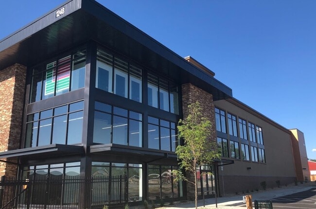
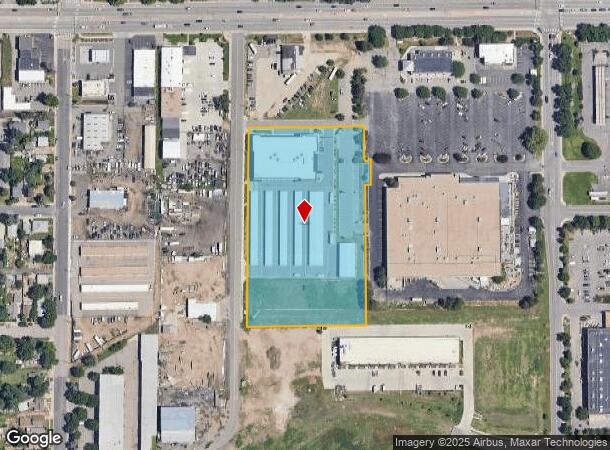
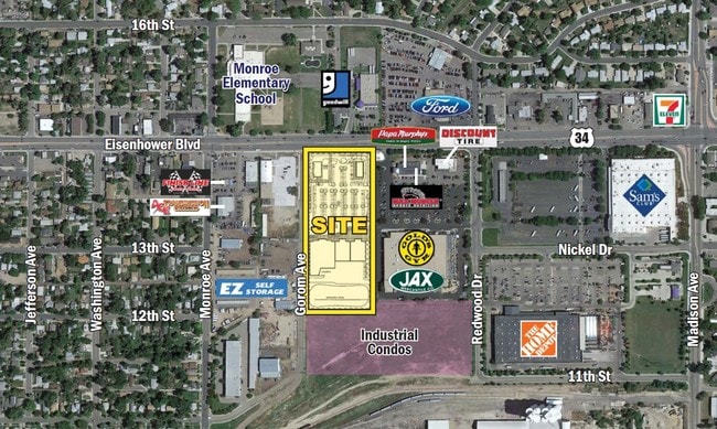
1248 Gorom Ave
Fort Collins, CO
Loveland Lumber 1St Addtn Amended Tr A,
95131-18-002
LOT 2, BLOCK 1, AMENDED TRACT A, LOVELAND LUMBER FIRST ADDTN AND LOT 4, BLK 1, SHOPKO SECOND SUB, LOV (20180014425)
Warehouse
Larimer
X
Colorado
08069C1189F
2,4
2024
4.80 AC
2025
Fort Collins/Loveland
001711
Denver
101,362 SF
DEMOGRAPHICS near 1248 Gorom Ave
1 Mile
3 Mile
5 Mile
2024 Total Population
11,505
60,127
95,755
2029 Population
12,012
63,163
101,184
Pop Growth 2024-2029
+ 4.41%
+ 5.05%
+ 5.67%
Average Age
42
42
42
2024 Total Households
5,359
25,648
39,896
HH Growth 2024-2029
+ 4.68%
+ 5.31%
+ 5.93%
Median Household Inc
$65,568
$71,208
$78,056
Avg Household Size
2.10
2.30
2.40
2024 Avg HH Vehicles
2.00
2.00
2.00
Median Home Value
$361,661
$388,558
$435,019
Median Year Built
1971
1982
1992
Nearby Places
Map Layers
Map Styles
 Street
 Aerial
- Restaurants
- Banks
- Shops
- Fitness
- Groceries
SALE & LEASE HISTORY
LISTING DATE
SALE/LEASE

Sep 25, 2016
For Lease
Nearby Properties
Address
Land Use
TOTAL SIZE
Lot Size
Zoning
Address
Land Use
TOTAL SIZE
Lot Size
Zoning
218,000 SF
45.72 AC
R1
Address
Land Use
TOTAL SIZE
Lot Size
Zoning
366,684 SF
29.44 AC
R3
Address
Land Use
TOTAL SIZE
Lot Size
Zoning
201,500 SF
28.43 AC
R1E
Address
Land Use
TOTAL SIZE
Lot Size
Zoning
200,420 SF
41.52 AC
R1
Address
Land Use
TOTAL SIZE
Lot Size
Zoning
109,639 SF
8.49 AC
B
Address
Land Use
TOTAL SIZE
Lot Size
Zoning
147,663 SF
5.01 AC
R3E
Address
Land Use
TOTAL SIZE
Lot Size
Zoning
96,723 SF
9.16 AC
I
Address
Land Use
TOTAL SIZE
Lot Size
Zoning
115,599 SF
13.15 AC
P38
Address
Land Use
TOTAL SIZE
Lot Size
Zoning
125,566 SF
8.27 AC
R3E
Address
Land Use
TOTAL SIZE
Lot Size
Zoning
35,554 SF
7.69 AC
Address
Land Use
TOTAL SIZE
Lot Size
Zoning
137,225 SF
25.76 AC
R1
Address
Land Use
TOTAL SIZE
Lot Size
Zoning
205,804 SF
21.91 AC
P51
Address
Land Use
TOTAL SIZE
Lot Size
Zoning
82,749 SF
25.54 AC
R2
Address
Land Use
TOTAL SIZE
Lot Size
Zoning
64,309 SF
14.54 AC
Address
Land Use
TOTAL SIZE
Lot Size
Zoning
137,432 SF
12.89 AC
B
Address
Land Use
TOTAL SIZE
Lot Size
Zoning
196,188 SF
13.26 AC
C
Address
Land Use
TOTAL SIZE
Lot Size
Zoning
565,272 SF
20.27 AC
Address
Land Use
TOTAL SIZE
Lot Size
Zoning
75,000 SF
2.96 AC
B
Address
Land Use
TOTAL SIZE
Lot Size
Zoning
296,360 SF
11.88 AC
B
Address
Land Use
TOTAL SIZE
Lot Size
Zoning
123,130 SF
4.17 AC
Address
Land Use
TOTAL SIZE
Lot Size
Zoning
165,709 SF
10.52 AC
Address
Land Use
TOTAL SIZE
Lot Size
Zoning
332,645 SF
14.16 AC
BUD
Address
Land Use
TOTAL SIZE
Lot Size
Zoning
83,954 SF
5.79 AC
FA
Address
Land Use
TOTAL SIZE
Lot Size
Zoning
269,696 SF
1.97 AC
Address
Land Use
TOTAL SIZE
Lot Size
Zoning
93,908 SF
28.86 AC
R1
Address
Land Use
TOTAL SIZE
Lot Size
Zoning
118,788 SF
14.01 AC
B
Address
Land Use
TOTAL SIZE
Lot Size
Zoning
137,950 SF
10.16 AC
Address
Land Use
TOTAL SIZE
Lot Size
Zoning
134,054 SF
14.45 AC
P59
Address
Land Use
TOTAL SIZE
Lot Size
Zoning
162,703 SF
14.92 AC
B
Address
Land Use
TOTAL SIZE
Lot Size
Zoning
90,060 SF
9.91 AC
P59
The World's #1 Commercial Real Estate Marketplace
Connect with us
© 2026 CoStar Group
The information above has been obtained from sources believed reliable. While we do not doubt its accuracy we have not verified it and make no guarantee, warranty or representation about it. It is your responsibility to independently confirm its accuracy and completeness. Any projections, opinions, assumptions, or estimates used are for example only and do not represent the current or future performance of the property. The value of this transaction to you depends on tax and other factors which should be evaluated by your tax, financial, and legal advisors. You and your advisors should conduct a careful, independent investigation of the property to determine to your satisfaction the suitability of the property for your needs.