Property Record
12482 Se Capps Rd, Clackamas, OR 97015
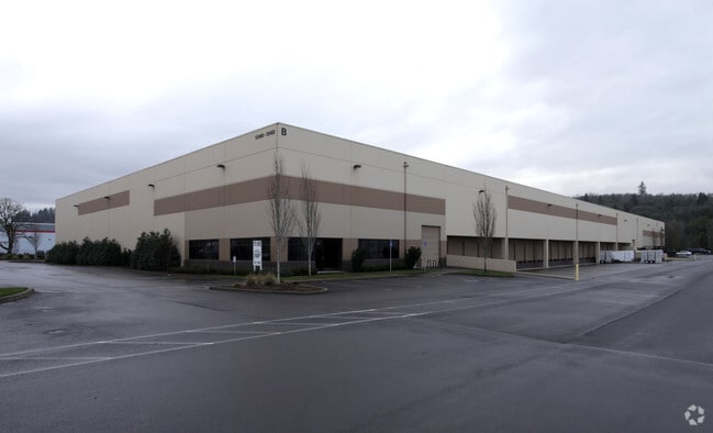

Property Detail
12482 Se Capps Rd
Portland-Vancouver-Hillsboro, OR-WA
SUBDIVISION IDM BUSINESS CENTER 4115 PT LT 2 SEE RELATED PROPERTIES 03890, 03800MA1 & 03800ME3
05017511
Clackamas
Industrialgeneral
Oregon
GI
2
AE The base floodplain where base flood elevations are provided. AE Zones are now used on new format FIRMs instead of A1-A30 Zones.
6 AC
2025
Clackamas/Milwaukie
2025
Portland
022108
NEARBY LISTINGS FOR SALE OR LEASE
DEMOGRAPHICS near 12482 Se Capps Rd
1 mile
3 mile
5 mile
2024 Total Population
390
57,892
157,627
2029 Population
386
58,122
158,636
Pop Growth 2024-2029
(1.03%)
+ 0.40%
+ 0.64%
Average Age
43
41
42
2024 Total Households
150
20,732
58,758
HH Growth 2024-2029
(1.33%)
+ 0.34%
+ 0.54%
Median Household Inc
$98,809
$99,944
$95,789
Avg Household Size
2.50
2.70
2.60
2024 Avg HH Vehicles
2.00
2.00
2.00
Median Home Value
$646,739
$628,319
$612,486
Median Year Built
1978
1992
1985
Nearby Places
Map Layers
Map Styles
 Street
 Aerial
Transit
 Traffic
 Biking
Places
Listings with unknown addresses are not visible on the map
- Restaurants
- Banks
- Shops
- Fitness
- Groceries
PUBLIC TRANSPORTATION
COMMUTER RAIL
Drive
Walk
Distance
13 min
5.6 mi
AIRPORT
Portland International
Drive
Walk
Distance
Portland International
28 min
16.9 mi
Freight Ports
Port of Portland
Drive
Walk
Distance
Port of Portland
31 min
16.4 mi
Nearby Properties
Address
Land Use
TOTAL SIZE
Lot Size
Zoning
Address
Land Use
TOTAL SIZE
Lot Size
Zoning
40.94 AC
IPU
Address
Land Use
TOTAL SIZE
Lot Size
Zoning
28.83 AC
RCO
Address
Land Use
TOTAL SIZE
Lot Size
Zoning
4,654 SF
73.99 AC
LI
Address
Land Use
TOTAL SIZE
Lot Size
Zoning
45 AC
GI
Address
Land Use
TOTAL SIZE
Lot Size
Zoning
Address
Land Use
TOTAL SIZE
Lot Size
Zoning
2,232 SF
15.74 AC
MUC
Address
Land Use
TOTAL SIZE
Lot Size
Zoning
9 AC
MUE
Address
Land Use
TOTAL SIZE
Lot Size
Zoning
22.99 AC
LI
Address
Land Use
TOTAL SIZE
Lot Size
Zoning
24 AC
LI
Address
Land Use
TOTAL SIZE
Lot Size
Zoning
12.16 AC
C3
Address
Land Use
TOTAL SIZE
Lot Size
Zoning
8 AC
MURM1
Address
Land Use
TOTAL SIZE
Lot Size
Zoning
20 AC
RTL
Address
Land Use
TOTAL SIZE
Lot Size
Zoning
2,089 SF
4.30 AC
MURM2
Address
Land Use
TOTAL SIZE
Lot Size
Zoning
14.06 AC
C3
Address
Land Use
TOTAL SIZE
Lot Size
Zoning
12 AC
LI
Address
Land Use
TOTAL SIZE
Lot Size
Zoning
1,032 SF
5.50 AC
MR2
Address
Land Use
TOTAL SIZE
Lot Size
Zoning
7.25 AC
LI
Address
Land Use
TOTAL SIZE
Lot Size
Zoning
3,342 SF
9.34 AC
MUE
Address
Land Use
TOTAL SIZE
Lot Size
Zoning
3.10 AC
RCO
Address
Land Use
TOTAL SIZE
Lot Size
Zoning
17.04 AC
GI
Address
Land Use
TOTAL SIZE
Lot Size
Zoning
10.11 AC
MR2
Address
Land Use
TOTAL SIZE
Lot Size
Zoning
2,510 SF
16.02 AC
GI
Address
Land Use
TOTAL SIZE
Lot Size
Zoning
11.69 AC
OC
Address
Land Use
TOTAL SIZE
Lot Size
Zoning
2,482 SF
5.14 AC
MR
Address
Land Use
TOTAL SIZE
Lot Size
Zoning
1 AC
MURX
Address
Land Use
TOTAL SIZE
Lot Size
Zoning
Address
Land Use
TOTAL SIZE
Lot Size
Zoning
70.97 AC
OP
Address
Land Use
TOTAL SIZE
Lot Size
Zoning
Address
Land Use
TOTAL SIZE
Lot Size
Zoning
The World's #1 Commercial Real Estate Marketplace
Connect with us
© 2026 CoStar Group
The information above has been obtained from sources believed reliable. While we do not doubt its accuracy we have not verified it and make no guarantee, warranty or representation about it. It is your responsibility to independently confirm its accuracy and completeness. Any projections, opinions, assumptions, or estimates used are for example only and do not represent the current or future performance of the property. The value of this transaction to you depends on tax and other factors which should be evaluated by your tax, financial, and legal advisors. You and your advisors should conduct a careful, independent investigation of the property to determine to your satisfaction the suitability of the property for your needs.