Property Record
1249 Cedar Rd, Chesapeake, VA 23322
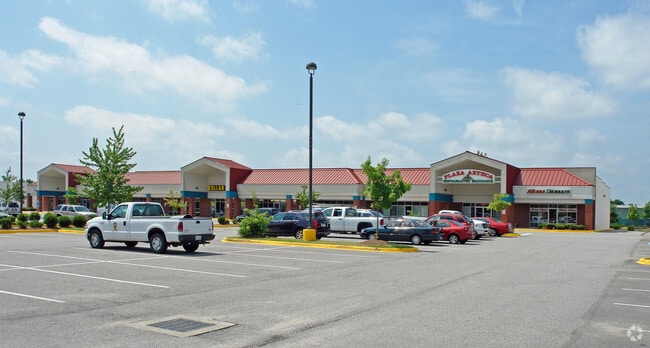

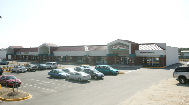
Property Detail
1249 Cedar Rd
0460000001490
PAR 5A2A RESUB PAR 4 & 5A2 LAS GAVIOTAS CTR 5.523
Stripcommercialcenter
Chesapeake City
B2: GENERA
Virginia
B and X Area of moderate flood hazard, usually the area between the limits of the 100-year and 500-year floods.
5.52 AC
2024
Deep Creek
2025
Hampton Roads
021016
Virginia Beach-Chesapeake-Norfolk, VA-NC
22,600 SF
NEARBY LISTINGS FOR SALE OR LEASE
DEMOGRAPHICS near 1249 Cedar Rd
1 mile
3 mile
5 mile
2025 Total Population
8,734
52,729
122,171
2030 Population
8,805
53,511
123,915
Pop Growth 2025-2030
+ 0.81%
+ 1.48%
+ 1.43%
Average Age
41
39
39
2025 Total Households
3,132
18,983
44,403
HH Growth 2025-2030
+ 0.83%
+ 1.55%
+ 1.47%
Median Household Inc
$132,577
$117,576
$106,304
Avg Household Size
2.80
2.70
2.70
2025 Avg HH Vehicles
2.00
2.00
2.00
Median Home Value
$445,487
$437,824
$407,669
Median Year Built
1994
1993
1992
Nearby Places
Map Layers
Map Styles
 Street
 Aerial
Transit
 Traffic
 Biking
Places
Listings with unknown addresses are not visible on the map
- Restaurants
- Banks
- Shops
- Fitness
- Groceries
PUBLIC TRANSPORTATION
AIRPORT
Norfolk International
Drive
Walk
Distance
Norfolk International
28 min
17.7 mi
Freight Ports
Virginia Port Authority - Portsmouth
Drive
Walk
Distance
Virginia Port Authority - Portsmouth
26 min
15.3 mi
SALE & LEASE HISTORY
LISTING DATE
SALE/LEASE

Jul 19, 2017
For Lease
Nearby Properties
Address
Land Use
TOTAL SIZE
Lot Size
Zoning
Address
Land Use
TOTAL SIZE
Lot Size
Zoning
6,820 SF
89.90 AC
R15S: RESI
Address
Land Use
TOTAL SIZE
Lot Size
Zoning
141,461 SF
169.22 AC
C1: CONSER
Address
Land Use
TOTAL SIZE
Lot Size
Zoning
338,400 SF
96.79 AC
A1: AGRICU
Address
Land Use
TOTAL SIZE
Lot Size
Zoning
26.78 AC
RMF1: MULT
Address
Land Use
TOTAL SIZE
Lot Size
Zoning
299,727 SF
170.79 AC
C1: CONSER
Address
Land Use
TOTAL SIZE
Lot Size
Zoning
154,540 SF
1.68 AC
O-I: OFFIC
Address
Land Use
TOTAL SIZE
Lot Size
Zoning
286,936 SF
15 AC
RMF1: MULT
Address
Land Use
TOTAL SIZE
Lot Size
Zoning
277,846 SF
12.50 AC
RMF1: MULT
Address
Land Use
TOTAL SIZE
Lot Size
Zoning
75,936 SF
11.13 AC
MULTI: MUL
Address
Land Use
TOTAL SIZE
Lot Size
Zoning
256,041 SF
12.32 AC
RMF1: MULT
Address
Land Use
TOTAL SIZE
Lot Size
Zoning
63,050 SF
27.71 AC
O-I: OFFIC
Address
Land Use
TOTAL SIZE
Lot Size
Zoning
107,223 SF
48.07 AC
O-I: OFFIC
Address
Land Use
TOTAL SIZE
Lot Size
Zoning
196,905 SF
46.84 AC
R15S: RESI
Address
Land Use
TOTAL SIZE
Lot Size
Zoning
67,508 SF
16.63 AC
O-I: OFFIC
Address
Land Use
TOTAL SIZE
Lot Size
Zoning
152,650 SF
5.53 AC
O-I: OFFIC
Address
Land Use
TOTAL SIZE
Lot Size
Zoning
213,740 SF
26.51 AC
B2: GENERA
Address
Land Use
TOTAL SIZE
Lot Size
Zoning
50,416 SF
13.30 AC
RMF1: MULT
Address
Land Use
TOTAL SIZE
Lot Size
Zoning
27,696 SF
15.80 AC
B1: NEIGHB
Address
Land Use
TOTAL SIZE
Lot Size
Zoning
110,988 SF
6.33 AC
O-I: OFFIC
Address
Land Use
TOTAL SIZE
Lot Size
Zoning
91,968 SF
6.33 AC
O-I: OFFIC
Address
Land Use
TOTAL SIZE
Lot Size
Zoning
50,978 SF
10.43 AC
B2: GENERA
Address
Land Use
TOTAL SIZE
Lot Size
Zoning
38,354 SF
2.23 AC
PUD: PLANN
Address
Land Use
TOTAL SIZE
Lot Size
Zoning
103,693 SF
5.83 AC
O-I: OFFIC
Address
Land Use
TOTAL SIZE
Lot Size
Zoning
4,300 SF
11.21 AC
PUD: PLANN
Address
Land Use
TOTAL SIZE
Lot Size
Zoning
53,454 SF
8.43 AC
B4: SHOPPI
Address
Land Use
TOTAL SIZE
Lot Size
Zoning
104,312 SF
8.06 AC
RMF1: MULT
Address
Land Use
TOTAL SIZE
Lot Size
Zoning
77,992 SF
10.14 AC
B2: GENERA
Address
Land Use
TOTAL SIZE
Lot Size
Zoning
92,440 SF
9.76 AC
RMF1: MULT
Address
Land Use
TOTAL SIZE
Lot Size
Zoning
210,964 SF
55.68 AC
M1: LIGHT
Address
Land Use
TOTAL SIZE
Lot Size
Zoning
83,808 SF
3.12 AC
O-I: OFFIC
The World's #1 Commercial Real Estate Marketplace
Connect with us
© 2026 CoStar Group
The information above has been obtained from sources believed reliable. While we do not doubt its accuracy we have not verified it and make no guarantee, warranty or representation about it. It is your responsibility to independently confirm its accuracy and completeness. Any projections, opinions, assumptions, or estimates used are for example only and do not represent the current or future performance of the property. The value of this transaction to you depends on tax and other factors which should be evaluated by your tax, financial, and legal advisors. You and your advisors should conduct a careful, independent investigation of the property to determine to your satisfaction the suitability of the property for your needs.