Property Record
12496 Us Route 60, Ashland, KY 41102

NEARBY LISTINGS FOR SALE OR LEASE
-
-
View all Ashland listings for sale on LoopNet.com
Property Detail
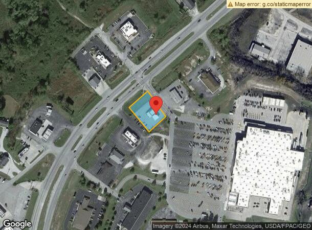
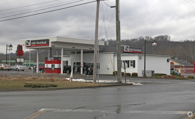
12496 Us Route 60
Huntington-Ashland, WV-KY-OH
Rt 60
016-00-00-008.00
CANNONSBURG .52 ACRE EAST FORK
Financialbuilding
Boyd
X
Kentucky
21019C0064D
0.52 AC
2025
Outlying Boyd County
2025
Huntington/Ashland
031101
DEMOGRAPHICS near 12496 Us Route 60
1 mile
3 mile
5 mile
2024 Total Population
1,123
6,348
15,185
2029 Population
1,099
6,243
15,016
Pop Growth 2024-2029
(2.14%)
(1.65%)
(1.11%)
Average Age
42
42
43
2024 Total Households
446
2,489
5,950
HH Growth 2024-2029
(2.02%)
(1.69%)
(1.13%)
Median Household Inc
$64,846
$61,757
$67,489
Avg Household Size
2.50
2.50
2.50
2024 Avg HH Vehicles
2.00
2.00
2.00
Median Home Value
$140,885
$151,056
$155,459
Median Year Built
1974
1978
1977
Nearby Places
Map Layers
Map Styles
 Street
 Aerial
Transit
 Traffic
 Biking
Places
Listings with unknown addresses are not visible on the map
- Restaurants
- Banks
- Shops
- Fitness
- Groceries
PUBLIC TRANSPORTATION
COMMUTER RAIL
Drive
Walk
Distance
14 min
8.3 mi
AIRPORT
Tri-State/Milton J Ferguson Field
Drive
Walk
Distance
Tri-State/Milton J Ferguson Field
20 min
13.1 mi
SALE & LEASE HISTORY
LISTING DATE
SALE/LEASE

Oct 29, 2018
For Sale
Nearby Properties
Address
Land Use
TOTAL SIZE
Lot Size
Zoning
Address
Land Use
TOTAL SIZE
Lot Size
Zoning
5.95 AC
RESIDENTIA
Address
Land Use
TOTAL SIZE
Lot Size
Zoning
0.52 AC
Address
Land Use
TOTAL SIZE
Lot Size
Zoning
87.12 AC
COMMERCIAL
Address
Land Use
TOTAL SIZE
Lot Size
Zoning
149,000 SF
0.18 AC
COMMERCIAL
Address
Land Use
TOTAL SIZE
Lot Size
Zoning
18.16 AC
Address
Land Use
TOTAL SIZE
Lot Size
Zoning
72.48 AC
COMMERCIAL
Address
Land Use
TOTAL SIZE
Lot Size
Zoning
23.57 AC
Address
Land Use
TOTAL SIZE
Lot Size
Zoning
11 AC
COMMERCIAL
Address
Land Use
TOTAL SIZE
Lot Size
Zoning
22 AC
OTHER
Address
Land Use
TOTAL SIZE
Lot Size
Zoning
41,784 SF
1.94 AC
Address
Land Use
TOTAL SIZE
Lot Size
Zoning
22,317 SF
4.40 AC
Z03
Address
Land Use
TOTAL SIZE
Lot Size
Zoning
31,220 SF
1.78 AC
COMMERCIAL
Address
Land Use
TOTAL SIZE
Lot Size
Zoning
Address
Land Use
TOTAL SIZE
Lot Size
Zoning
51.80 AC
Address
Land Use
TOTAL SIZE
Lot Size
Zoning
Address
Land Use
TOTAL SIZE
Lot Size
Zoning
30.71 AC
Z02
Address
Land Use
TOTAL SIZE
Lot Size
Zoning
35.04 AC
COMMERCIAL
Address
Land Use
TOTAL SIZE
Lot Size
Zoning
1.04 AC
COMMERCIAL
Address
Land Use
TOTAL SIZE
Lot Size
Zoning
6.72 AC
Address
Land Use
TOTAL SIZE
Lot Size
Zoning
25,524 SF
2 AC
Address
Land Use
TOTAL SIZE
Lot Size
Zoning
Address
Land Use
TOTAL SIZE
Lot Size
Zoning
9,064 SF
37.16 AC
RESIDENTIA
Address
Land Use
TOTAL SIZE
Lot Size
Zoning
1.10 AC
Address
Land Use
TOTAL SIZE
Lot Size
Zoning
28,239 SF
2.17 AC
Address
Land Use
TOTAL SIZE
Lot Size
Zoning
12.86 AC
Z02
Address
Land Use
TOTAL SIZE
Lot Size
Zoning
1 AC
Z02
Address
Land Use
TOTAL SIZE
Lot Size
Zoning
0.11 AC
COMMERCIAL
Address
Land Use
TOTAL SIZE
Lot Size
Zoning
1.29 AC
Address
Land Use
TOTAL SIZE
Lot Size
Zoning
0.21 AC
COMMERCIAL
Address
Land Use
TOTAL SIZE
Lot Size
Zoning
The World's #1 Commercial Real Estate Marketplace
Connect with us
© 2026 CoStar Group
The information above has been obtained from sources believed reliable. While we do not doubt its accuracy we have not verified it and make no guarantee, warranty or representation about it. It is your responsibility to independently confirm its accuracy and completeness. Any projections, opinions, assumptions, or estimates used are for example only and do not represent the current or future performance of the property. The value of this transaction to you depends on tax and other factors which should be evaluated by your tax, financial, and legal advisors. You and your advisors should conduct a careful, independent investigation of the property to determine to your satisfaction the suitability of the property for your needs.