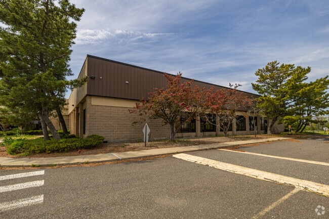
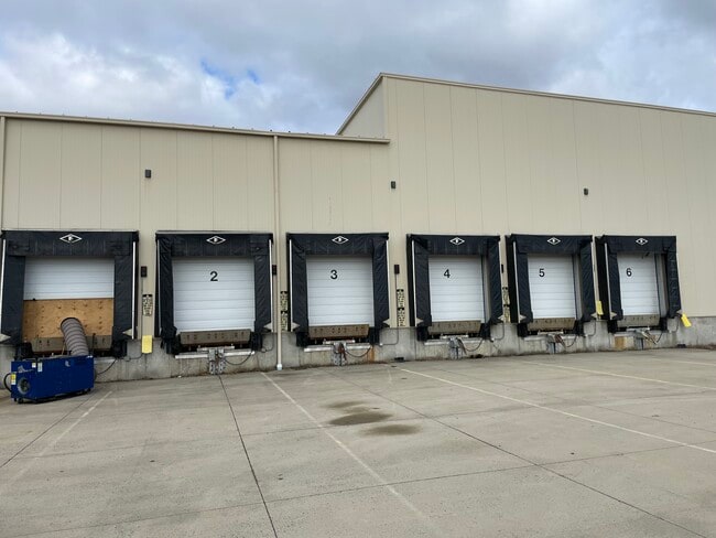
Property Record
125 Access Rd, Stratford, CT 06615

Current Lease Availabilities
Property Detail
125 Access Rd
STRA-000405-000013-000002
Greater Bridgeport
Manufacturinglight
Connecticut
MA
2
AE The base floodplain where base flood elevations are provided. AE Zones are now used on new format FIRMs instead of A1-A30 Zones.
11.42 AC
2025
Stratford
2025
Westchester/So Connecticut
080500
Bridgeport-Stamford-Danbury, CT
184,324 SF
NEARBY LISTINGS FOR SALE OR LEASE
DEMOGRAPHICS near 125 Access Rd
1 mile
3 mile
5 mile
2025 Total Population
6,597
69,783
197,099
2030 Population
6,784
71,649
201,929
Pop Growth 2025-2030
+ 2.83%
+ 2.67%
+ 2.45%
Average Age
42
41
40
2025 Total Households
2,641
27,155
73,830
HH Growth 2025-2030
+ 3.07%
+ 2.85%
+ 2.57%
Median Household Inc
$73,824
$72,418
$69,840
Avg Household Size
2.50
2.50
2.50
2025 Avg HH Vehicles
2.00
2.00
2.00
Median Home Value
$398,804
$342,574
$343,644
Median Year Built
1956
1950
1952
Nearby Places
Map Layers
Map Styles
 Street
 Aerial
Layers
 Traffic
 Biking
Places
Listings with unknown addresses are not visible on the map
- Restaurants
- Banks
- Shops
- Fitness
- Groceries
PUBLIC TRANSPORTATION
COMMUTER RAIL
Stratford Station (New Haven Line - Metro-North Commuter Railroad Company (Metro-North))
Drive
Walk
Distance
Stratford Station (New Haven Line - Metro-North Commuter Railroad Company (Metro-North))
4 min
1.9 mi
Bridgeport Station (New Haven Line - Shore Line East, Shore Line East - Shore Line East)
Drive
Walk
Distance
Bridgeport Station (New Haven Line - Shore Line East, Shore Line East - Shore Line East)
8 min
4.4 mi
AIRPORT
Tweed/New Haven
Drive
Walk
Distance
Tweed/New Haven
34 min
20.4 mi
Long Island MacArthur
Drive
Walk
Distance
Long Island MacArthur
115 min
38.2 mi
Freight Ports
Port of New Haven
Drive
Walk
Distance
Port of New Haven
29 min
17.6 mi
Nearby Properties
Address
Land Use
TOTAL SIZE
Lot Size
Zoning
Address
Land Use
TOTAL SIZE
Lot Size
Zoning
22.85 AC
Address
Land Use
TOTAL SIZE
Lot Size
Zoning
145,000 SF
15.70 AC
ILI
Address
Land Use
TOTAL SIZE
Lot Size
Zoning
39,031 SF
451.38 AC
ADD
Address
Land Use
TOTAL SIZE
Lot Size
Zoning
4.14 AC
MUEM
Address
Land Use
TOTAL SIZE
Lot Size
Zoning
178,265 SF
6.92 AC
Address
Land Use
TOTAL SIZE
Lot Size
Zoning
23 AC
RC
Address
Land Use
TOTAL SIZE
Lot Size
Zoning
23.70 AC
RB
Address
Land Use
TOTAL SIZE
Lot Size
Zoning
368,000 SF
18.69 AC
D-17
Address
Land Use
TOTAL SIZE
Lot Size
Zoning
225,264 SF
28.22 AC
MC
Address
Land Use
TOTAL SIZE
Lot Size
Zoning
110,506 SF
0.06 AC
RBB
Address
Land Use
TOTAL SIZE
Lot Size
Zoning
722 SF
47.10 AC
RM-1
Address
Land Use
TOTAL SIZE
Lot Size
Zoning
630 SF
107.70 AC
RA
Address
Land Use
TOTAL SIZE
Lot Size
Zoning
265,059 SF
47.61 AC
F-17
Address
Land Use
TOTAL SIZE
Lot Size
Zoning
79,869 SF
13.81 AC
G-12
Address
Land Use
TOTAL SIZE
Lot Size
Zoning
90 AC
RA
Address
Land Use
TOTAL SIZE
Lot Size
Zoning
8.27 AC
C
Address
Land Use
TOTAL SIZE
Lot Size
Zoning
89,760 SF
18.58 AC
RM-1
Address
Land Use
TOTAL SIZE
Lot Size
Zoning
128,236 SF
2.88 AC
E-13
Address
Land Use
TOTAL SIZE
Lot Size
Zoning
33.57 AC
RC
Address
Land Use
TOTAL SIZE
Lot Size
Zoning
121,332 SF
19.59 AC
F-12
Address
Land Use
TOTAL SIZE
Lot Size
Zoning
9.12 AC
R12.
Address
Land Use
TOTAL SIZE
Lot Size
Zoning
178,466 SF
5.90 AC
RS-4
Address
Land Use
TOTAL SIZE
Lot Size
Zoning
12.09 AC
RC
Address
Land Use
TOTAL SIZE
Lot Size
Zoning
7.39 AC
IHI
Address
Land Use
TOTAL SIZE
Lot Size
Zoning
3,108 SF
9 AC
F-15
Address
Land Use
TOTAL SIZE
Lot Size
Zoning
169,432 SF
12.02 AC
MC
Address
Land Use
TOTAL SIZE
Lot Size
Zoning
18,849 SF
3.29 AC
E-14
Address
Land Use
TOTAL SIZE
Lot Size
Zoning
231,026 SF
7.05 AC
E-13
Address
Land Use
TOTAL SIZE
Lot Size
Zoning
130,990 SF
13.12 AC
MA
Address
Land Use
TOTAL SIZE
Lot Size
Zoning
117,781 SF
12.41 AC
CA
The World's #1 Commercial Real Estate Marketplace
Connect with us
© 2026 CoStar Group
The information above has been obtained from sources believed reliable. While we do not doubt its accuracy we have not verified it and make no guarantee, warranty or representation about it. It is your responsibility to independently confirm its accuracy and completeness. Any projections, opinions, assumptions, or estimates used are for example only and do not represent the current or future performance of the property. The value of this transaction to you depends on tax and other factors which should be evaluated by your tax, financial, and legal advisors. You and your advisors should conduct a careful, independent investigation of the property to determine to your satisfaction the suitability of the property for your needs.