Property Record
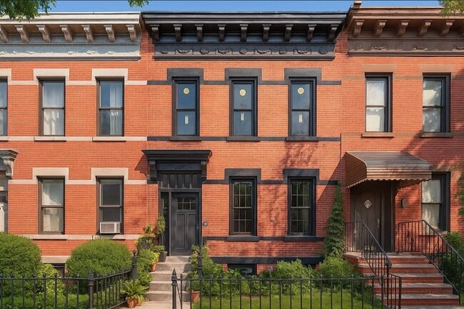
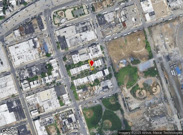
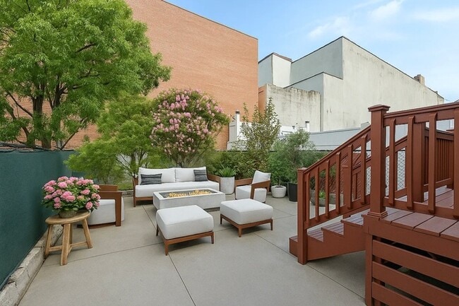
125 Beadel St, Brooklyn, NY 11222
This Property Is For Sale
NEARBY LISTINGS FOR SALE OR LEASE
Property Detail
125 Beadel St
New York-Jersey City-White Plains, NY-NJ
Kings
02836-0034
New York
Duplex
0.04 AC
X
East Williamsburg
3604970206F
Long Island (New York)
1,800 SF
DEMOGRAPHICS near 125 Beadel St
1 Mile
3 Mile
5 Mile
2024 Total Population
53,501
1,243,275
3,389,414
2029 Population
53,732
1,260,534
3,434,554
Pop Growth 2024-2029
+ 0.43%
+ 1.39%
+ 1.33%
Average Age
37
38
40
2024 Total Households
24,989
521,716
1,430,879
HH Growth 2024-2029
0.00%
+ 1.66%
+ 1.80%
Median Household Inc
$127,380
$94,477
$99,087
Avg Household Size
2.10
2.30
2.20
2024 Avg HH Vehicles
.00
.00
.00
Median Home Value
$1,071,016
$896,849
$933,173
Median Year Built
1948
1953
1952
Nearby Places
- Restaurants
- Banks
- Shops
- Fitness
- Groceries
PUBLIC TRANSPORTATION
TRANSIT/SUBWAY
Graham Avenue (L - New York MTA Subway (The Subway))
DRIVE
WALK
Distance
Graham Avenue (L - New York MTA Subway (The Subway))
2 min
16 min
0.8 mi
Grand Street (L Line) (L - New York MTA Subway (The Subway))
DRIVE
WALK
Distance
Grand Street (L Line) (L - New York MTA Subway (The Subway))
2 min
18 min
0.9 mi
Nassau Avenue (G - New York MTA Subway (The Subway))
DRIVE
WALK
Distance
Nassau Avenue (G - New York MTA Subway (The Subway))
4 min
19 min
1.0 mi
Lorimer Street (L Line) (L - New York MTA Subway (The Subway))
DRIVE
WALK
Distance
Lorimer Street (L Line) (L - New York MTA Subway (The Subway))
3 min
20 min
1.0 mi
COMMUTER RAIL
Hunterspoint Avenue Station (Hempstead Branch - Long Island Rail Road, Oyster Bay Branch - Long Island Rail Road)
DRIVE
WALK
Distance
Hunterspoint Avenue Station (Hempstead Branch - Long Island Rail Road, Oyster Bay Branch - Long Island Rail Road)
6 min
2.4 mi
Long Island City Station (Hempstead Branch - Long Island Rail Road)
DRIVE
WALK
Distance
Long Island City Station (Hempstead Branch - Long Island Rail Road)
7 min
2.8 mi
AIRPORT
LaGuardia
DRIVE
WALK
Distance
LaGuardia
11 min
6.0 mi
John F Kennedy International
DRIVE
WALK
Distance
John F Kennedy International
21 min
14.2 mi
Newark Liberty International
DRIVE
WALK
Distance
Newark Liberty International
28 min
16.1 mi
Freight Ports
NY - Red Hook Container Terminal
DRIVE
WALK
Distance
NY - Red Hook Container Terminal
11 min
5.9 mi
Nearby Properties
Address
Land Use
TOTAL SIZE
Lot Size
Zoning
Address
Land Use
TOTAL SIZE
Lot Size
Zoning
8,462,176 SF
61.41 AC
R7-2
Address
Land Use
TOTAL SIZE
Lot Size
Zoning
2,812,739 SF
2.10 AC
C5-3
Address
Land Use
TOTAL SIZE
Lot Size
Zoning
2,400,000 SF
15.14 AC
C5-2
Address
Land Use
TOTAL SIZE
Lot Size
Zoning
2,124,441 SF
17.29 AC
R8
Address
Land Use
TOTAL SIZE
Lot Size
Zoning
1,233,394 SF
1.78 AC
C5-3
Address
Land Use
TOTAL SIZE
Lot Size
Zoning
1,104,505 SF
2.32 AC
C4-7
Address
Land Use
TOTAL SIZE
Lot Size
Zoning
916,553 SF
1.39 AC
C5-3
Address
Land Use
TOTAL SIZE
Lot Size
Zoning
940,000 SF
1.44 AC
C6-2
Address
Land Use
TOTAL SIZE
Lot Size
Zoning
1,050,990 SF
1.21 AC
C52.5
Address
Land Use
TOTAL SIZE
Lot Size
Zoning
7,058,736 SF
147.61 AC
M3-1
Address
Land Use
TOTAL SIZE
Lot Size
Zoning
3,122,165 SF
19.02 AC
R7-2
Address
Land Use
TOTAL SIZE
Lot Size
Zoning
1,065,915 SF
2.13 AC
M16R10
Address
Land Use
TOTAL SIZE
Lot Size
Zoning
1,385,425 SF
6.43 AC
R8
Address
Land Use
TOTAL SIZE
Lot Size
Zoning
1,035,307 SF
0.86 AC
C5-3
Address
Land Use
TOTAL SIZE
Lot Size
Zoning
900,514 SF
0.87 AC
C5-3
Address
Land Use
TOTAL SIZE
Lot Size
Zoning
599,102 SF
0.81 AC
C5-3
Address
Land Use
TOTAL SIZE
Lot Size
Zoning
840,000 SF
1.04 AC
C4-6
Address
Land Use
TOTAL SIZE
Lot Size
Zoning
1,503,235 SF
5.28 AC
C2-7
Address
Land Use
TOTAL SIZE
Lot Size
Zoning
805,287 SF
1 AC
R10
Address
Land Use
TOTAL SIZE
Lot Size
Zoning
986,431 SF
1.06 AC
C52.5
Address
Land Use
TOTAL SIZE
Lot Size
Zoning
1,321,050 SF
1.89 AC
C1-9
Address
Land Use
TOTAL SIZE
Lot Size
Zoning
1,159,795 SF
1.93 AC
C5-3
Address
Land Use
TOTAL SIZE
Lot Size
Zoning
666,376 SF
0.80 AC
C5-3
Address
Land Use
TOTAL SIZE
Lot Size
Zoning
2,948,300 SF
27.71 AC
R7-2
Address
Land Use
TOTAL SIZE
Lot Size
Zoning
984,760 SF
2.04 AC
M3-1
Address
Land Use
TOTAL SIZE
Lot Size
Zoning
898,734 SF
1.11 AC
C5-3
Address
Land Use
TOTAL SIZE
Lot Size
Zoning
665,110 SF
0.88 AC
C5-3
Address
Land Use
TOTAL SIZE
Lot Size
Zoning
818,726 SF
1.65 AC
C1-9
Address
Land Use
TOTAL SIZE
Lot Size
Zoning
700,621 SF
1.06 AC
C5-3
Address
Land Use
TOTAL SIZE
Lot Size
Zoning
740,301 SF
0.94 AC
C1-9
The World's #1 Commercial Real Estate Marketplace
Connect with us
© 2025 CoStar Group
The information above has been obtained from sources believed reliable. While we do not doubt its accuracy we have not verified it and make no guarantee, warranty or representation about it. It is your responsibility to independently confirm its accuracy and completeness. Any projections, opinions, assumptions, or estimates used are for example only and do not represent the current or future performance of the property. The value of this transaction to you depends on tax and other factors which should be evaluated by your tax, financial, and legal advisors. You and your advisors should conduct a careful, independent investigation of the property to determine to your satisfaction the suitability of the property for your needs.