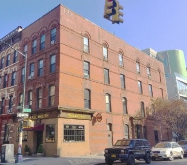
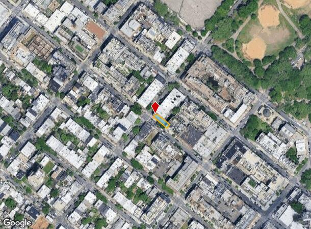
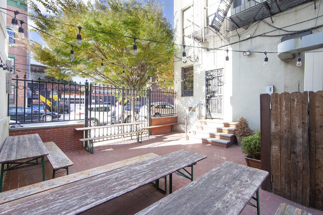
Property Record
125 Bedford Ave, Brooklyn, NY 11211
NEARBY LISTINGS FOR SALE OR LEASE
Property Detail
125 Bedford Ave
02298-0001
Kings
Apartment
New York
X
1
3604970202F
0.06 AC
2024
North Brooklyn
2025
Long Island (New York)
051700
New York-Jersey City-White Plains, NY-NJ
8,000 SF
DEMOGRAPHICS near 125 Bedford Ave
1 Mile
3 Mile
5 Mile
2024 Total Population
136,437
1,327,983
3,141,032
2029 Population
131,157
1,253,572
2,955,388
Pop Growth 2024-2029
(3.87%)
(5.60%)
(5.91%)
Average Age
36
38
39
2024 Total Households
61,361
599,658
1,370,537
HH Growth 2024-2029
(4.42%)
(5.99%)
(6.24%)
Median Household Inc
$107,819
$95,379
$91,206
Avg Household Size
2.20
2.10
2.20
2024 Avg HH Vehicles
.00
.00
.00
Median Home Value
$1,047,065
$954,607
$905,853
Median Year Built
1956
1952
1952
Nearby Places
- Restaurants
- Banks
- Shops
- Fitness
- Groceries
PUBLIC TRANSPORTATION
TRANSIT/SUBWAY
Bedford Avenue (L - New York MTA Subway (The Subway))
DRIVE
WALK
Distance
Bedford Avenue (L - New York MTA Subway (The Subway))
2 min
3 min
0.2 mi
Nassau Avenue (G - New York MTA Subway (The Subway))
DRIVE
WALK
Distance
Nassau Avenue (G - New York MTA Subway (The Subway))
2 min
8 min
0.5 mi
Metropolitan Avenue (G - New York MTA Subway (The Subway))
DRIVE
WALK
Distance
Metropolitan Avenue (G - New York MTA Subway (The Subway))
2 min
10 min
0.6 mi
Lorimer Street (L Line) (L - New York MTA Subway (The Subway))
DRIVE
WALK
Distance
Lorimer Street (L Line) (L - New York MTA Subway (The Subway))
2 min
11 min
0.6 mi
Graham Avenue (L - New York MTA Subway (The Subway))
DRIVE
WALK
Distance
Graham Avenue (L - New York MTA Subway (The Subway))
3 min
16 min
0.9 mi
COMMUTER RAIL
Hunterspoint Avenue Station (Hempstead Branch - Long Island Rail Road, Oyster Bay Branch - Long Island Rail Road)
DRIVE
WALK
Distance
Hunterspoint Avenue Station (Hempstead Branch - Long Island Rail Road, Oyster Bay Branch - Long Island Rail Road)
7 min
2.3 mi
Long Island City Station (Hempstead Branch - Long Island Rail Road)
DRIVE
WALK
Distance
Long Island City Station (Hempstead Branch - Long Island Rail Road)
8 min
2.5 mi
AIRPORT
LaGuardia
DRIVE
WALK
Distance
LaGuardia
16 min
7.1 mi
John F Kennedy International
DRIVE
WALK
Distance
John F Kennedy International
25 min
15.3 mi
Newark Liberty International
DRIVE
WALK
Distance
Newark Liberty International
27 min
15.4 mi
Freight Ports
NY - Red Hook Container Terminal
DRIVE
WALK
Distance
NY - Red Hook Container Terminal
10 min
5.2 mi
SALE & LEASE HISTORY
LISTING DATE
SALE/LEASE

Oct 21, 2019
For Lease
Nearby Properties
Address
Land Use
TOTAL SIZE
Lot Size
Zoning
Address
Land Use
TOTAL SIZE
Lot Size
Zoning
2,245,112 SF
2.02 AC
C6-6
Address
Land Use
TOTAL SIZE
Lot Size
Zoning
8,462,176 SF
61.41 AC
R7-2
Address
Land Use
TOTAL SIZE
Lot Size
Zoning
2,161,994 SF
3.79 AC
M1-5
Address
Land Use
TOTAL SIZE
Lot Size
Zoning
2,354,289 SF
3.96 AC
C6-4
Address
Land Use
TOTAL SIZE
Lot Size
Zoning
1,678,135 SF
1.01 AC
C5-3
Address
Land Use
TOTAL SIZE
Lot Size
Zoning
2,812,739 SF
2.10 AC
C5-3
Address
Land Use
TOTAL SIZE
Lot Size
Zoning
1,642,675 SF
1.05 AC
C6-7
Address
Land Use
TOTAL SIZE
Lot Size
Zoning
1,048,620 SF
5.67 AC
C6-4
Address
Land Use
TOTAL SIZE
Lot Size
Zoning
1,586,876 SF
1.87 AC
C5-3
Address
Land Use
TOTAL SIZE
Lot Size
Zoning
2,535,958 SF
2.94 AC
C6-4
Address
Land Use
TOTAL SIZE
Lot Size
Zoning
2,344,406 SF
1.84 AC
C5-3
Address
Land Use
TOTAL SIZE
Lot Size
Zoning
1,009,855 SF
4.90 AC
C6-3
Address
Land Use
TOTAL SIZE
Lot Size
Zoning
1,448,897 SF
1.56 AC
C6-6
Address
Land Use
TOTAL SIZE
Lot Size
Zoning
2,400,000 SF
15.14 AC
C5-2
Address
Land Use
TOTAL SIZE
Lot Size
Zoning
2,124,441 SF
17.29 AC
R8
Address
Land Use
TOTAL SIZE
Lot Size
Zoning
1,009,855 SF
3.25 AC
C6-3
Address
Land Use
TOTAL SIZE
Lot Size
Zoning
1,160,500 SF
1.62 AC
C6-6
Address
Land Use
TOTAL SIZE
Lot Size
Zoning
1,015,287 SF
1 AC
C5-3
Address
Land Use
TOTAL SIZE
Lot Size
Zoning
1,233,394 SF
1.78 AC
C5-3
Address
Land Use
TOTAL SIZE
Lot Size
Zoning
1,134,017 SF
1.05 AC
C5-3
Address
Land Use
TOTAL SIZE
Lot Size
Zoning
822,014 SF
1.38 AC
C52.5
Address
Land Use
TOTAL SIZE
Lot Size
Zoning
1,104,505 SF
2.32 AC
C4-7
Address
Land Use
TOTAL SIZE
Lot Size
Zoning
1,560,607 SF
2.69 AC
C6-6
Address
Land Use
TOTAL SIZE
Lot Size
Zoning
916,553 SF
1.39 AC
C5-3
Address
Land Use
TOTAL SIZE
Lot Size
Zoning
1,033,031 SF
1.87 AC
C52.5
Address
Land Use
TOTAL SIZE
Lot Size
Zoning
1,079,378 SF
0.52 AC
C6-7
Address
Land Use
TOTAL SIZE
Lot Size
Zoning
1,636,000 SF
1.09 AC
C6-4
Address
Land Use
TOTAL SIZE
Lot Size
Zoning
1,064,223 SF
0.88 AC
C52.5
Address
Land Use
TOTAL SIZE
Lot Size
Zoning
940,000 SF
1.44 AC
C6-2
Address
Land Use
TOTAL SIZE
Lot Size
Zoning
1,242,587 SF
1.49 AC
C6-6
The World's #1 Commercial Real Estate Marketplace
Connect with us
© 2025 CoStar Group
The information above has been obtained from sources believed reliable. While we do not doubt its accuracy we have not verified it and make no guarantee, warranty or representation about it. It is your responsibility to independently confirm its accuracy and completeness. Any projections, opinions, assumptions, or estimates used are for example only and do not represent the current or future performance of the property. The value of this transaction to you depends on tax and other factors which should be evaluated by your tax, financial, and legal advisors. You and your advisors should conduct a careful, independent investigation of the property to determine to your satisfaction the suitability of the property for your needs.