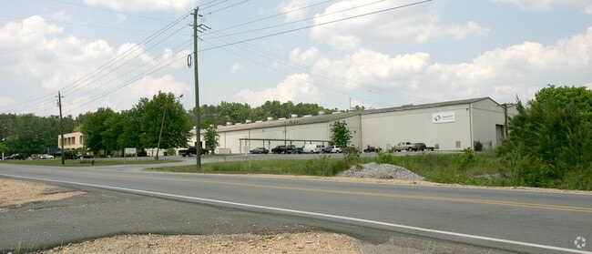
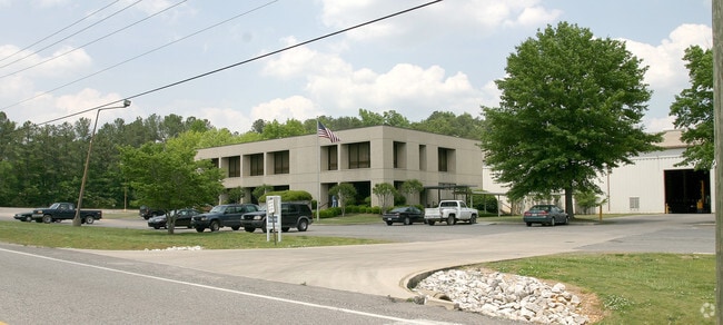
Property Record
125 Carson Rd N, Birmingham, AL 35215

NEARBY LISTINGS FOR SALE OR LEASE
Property Detail
125 Carson Rd N
13-00-11-1-000-005.000
BEG INTER NE/L CARSON RD AND NW/L OF L& N RR ROW IN SEC 11 TP 16 R 2 TH NE 1245 FT TH NW 284 FT TH W 350 FT TO ROW TH SWLY & WLY ALG S/L OF ROW 600 FT TH SW 40 FT TO E/L OF ELFRETH JOHNSON ROW TH SLY 760 FT TO N CARSON RD TH SE 735 FT TO POB
Lightindustrial
Jefferson
X
Alabama
01073C0237H
21.85 AC
2023
Fultondale
2024
Birmingham
011210
Birmingham-Hoover, AL
113,175 SF
DEMOGRAPHICS near 125 Carson Rd N
1 Mile
3 Mile
5 Mile
2024 Total Population
2,490
29,335
75,138
2029 Population
2,481
28,785
73,601
Pop Growth 2024-2029
(0.36%)
(1.87%)
(2.05%)
Average Age
36
36
37
2024 Total Households
929
10,911
28,332
HH Growth 2024-2029
(0.43%)
(1.93%)
(2.09%)
Median Household Inc
$36,972
$43,560
$49,907
Avg Household Size
2.60
2.60
2.60
2024 Avg HH Vehicles
2.00
2.00
2.00
Median Home Value
$162,758
$145,281
$149,215
Median Year Built
1977
1975
1976
Nearby Places
Map Layers
Map Styles
 Street
 Aerial
- Restaurants
- Banks
- Shops
- Fitness
- Groceries
PUBLIC TRANSPORTATION
AIRPORT
Birmingham-Shuttlesworth International
DRIVE
WALK
Distance
Birmingham-Shuttlesworth International
21 min
12.6 mi
Freight Ports
Port of Mobile
DRIVE
WALK
Distance
Port of Mobile
300 min
269.1 mi
Nearby Properties
Address
Land Use
TOTAL SIZE
Lot Size
Zoning
Address
Land Use
TOTAL SIZE
Lot Size
Zoning
725,840 SF
89 AC
CM2
Address
Land Use
TOTAL SIZE
Lot Size
Zoning
623,200 SF
50 AC
CM2
Address
Land Use
TOTAL SIZE
Lot Size
Zoning
218,922 SF
21 AC
CR5
Address
Land Use
TOTAL SIZE
Lot Size
Zoning
412,320 SF
16.50 AC
I2
Address
Land Use
TOTAL SIZE
Lot Size
Zoning
192,596 SF
13.79 AC
CR5
Address
Land Use
TOTAL SIZE
Lot Size
Zoning
147,200 SF
7.93 AC
CR5
Address
Land Use
TOTAL SIZE
Lot Size
Zoning
118,522 SF
7.80 AC
I4
Address
Land Use
TOTAL SIZE
Lot Size
Zoning
531,808 SF
23.96 AC
I4&A
Address
Land Use
TOTAL SIZE
Lot Size
Zoning
92,560 SF
15.36 AC
I4
Address
Land Use
TOTAL SIZE
Lot Size
Zoning
502,302 SF
24.61 AC
I4&A
Address
Land Use
TOTAL SIZE
Lot Size
Zoning
125,252 SF
8.07 AC
R4
Address
Land Use
TOTAL SIZE
Lot Size
Zoning
163,790 SF
18 AC
I-4
Address
Land Use
TOTAL SIZE
Lot Size
Zoning
179,464 SF
17.70 AC
M3
Address
Land Use
TOTAL SIZE
Lot Size
Zoning
80,834 SF
7.13 AC
CR5
Address
Land Use
TOTAL SIZE
Lot Size
Zoning
340,000 SF
29 AC
I4
Address
Land Use
TOTAL SIZE
Lot Size
Zoning
26,169 SF
71 AC
R2
Address
Land Use
TOTAL SIZE
Lot Size
Zoning
109,878 SF
10 AC
C1
Address
Land Use
TOTAL SIZE
Lot Size
Zoning
74,159 SF
2.50 AC
INST
Address
Land Use
TOTAL SIZE
Lot Size
Zoning
257,988 SF
CM2
Address
Land Use
TOTAL SIZE
Lot Size
Zoning
63,736 SF
11 AC
I
Address
Land Use
TOTAL SIZE
Lot Size
Zoning
84,602 SF
11.20 AC
B2
Address
Land Use
TOTAL SIZE
Lot Size
Zoning
118,041 SF
5.10 AC
C1
Address
Land Use
TOTAL SIZE
Lot Size
Zoning
99,917 SF
17.60 AC
M-3
Address
Land Use
TOTAL SIZE
Lot Size
Zoning
44,912 SF
14.50 AC
I4-U
Address
Land Use
TOTAL SIZE
Lot Size
Zoning
100,788 SF
17 AC
I2
Address
Land Use
TOTAL SIZE
Lot Size
Zoning
182,751 SF
8.10 AC
I4
Address
Land Use
TOTAL SIZE
Lot Size
Zoning
86,240 SF
104 AC
CM2
Address
Land Use
TOTAL SIZE
Lot Size
Zoning
61,472 SF
18.84 AC
INT-
The World's #1 Commercial Real Estate Marketplace
Connect with us
© 2025 CoStar Group
The information above has been obtained from sources believed reliable. While we do not doubt its accuracy we have not verified it and make no guarantee, warranty or representation about it. It is your responsibility to independently confirm its accuracy and completeness. Any projections, opinions, assumptions, or estimates used are for example only and do not represent the current or future performance of the property. The value of this transaction to you depends on tax and other factors which should be evaluated by your tax, financial, and legal advisors. You and your advisors should conduct a careful, independent investigation of the property to determine to your satisfaction the suitability of the property for your needs.