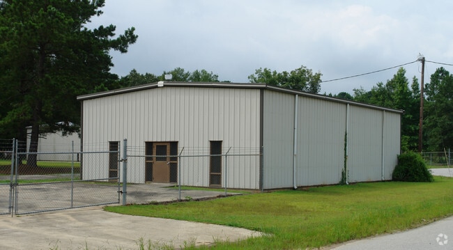
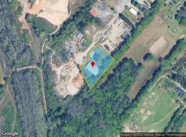
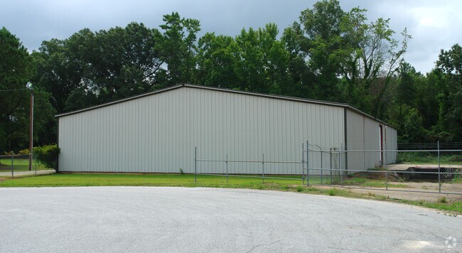
Property Record
125 E Bombay Dr, Columbia, SC 29209
NEARBY LISTINGS FOR SALE OR LEASE
Property Detail
125 E Bombay Dr
Columbia, SC
Bluff Induscommercial Properties
16100-04-04
LOT 6 137.8X180X250X348X197.6 #PR 42-359 #OM 0937-01-42
Commercialnec
Richland
X
South Carolina
45079C0387L
6,137
2025
1.66 AC
2024
Southeast Columbia
011608
Columbia
11,200 SF
DEMOGRAPHICS near 125 E Bombay Dr
1 Mile
3 Mile
5 Mile
2024 Total Population
2,112
13,928
49,670
2029 Population
2,156
14,191
50,593
Pop Growth 2024-2029
+ 2.08%
+ 1.89%
+ 1.86%
Average Age
41
37
37
2024 Total Households
639
5,742
22,618
HH Growth 2024-2029
+ 2.35%
+ 2.11%
+ 2.08%
Median Household Inc
$39,726
$50,529
$53,335
Avg Household Size
2.40
2.30
2.10
2024 Avg HH Vehicles
2.00
2.00
2.00
Median Home Value
$123,469
$173,798
$191,918
Median Year Built
1974
1989
1981
Nearby Places
Map Layers
Map Styles
 Street
 Aerial
- Restaurants
- Banks
- Shops
- Fitness
- Groceries
PUBLIC TRANSPORTATION
COMMUTER RAIL
Columbia Amtrak Station (Silver Star - Amtrak)
DRIVE
WALK
Distance
Columbia Amtrak Station (Silver Star - Amtrak)
14 min
7.2 mi
AIRPORT
Columbia Metro
DRIVE
WALK
Distance
Columbia Metro
27 min
14.5 mi
Freight Ports
North Charleston Terminal
DRIVE
WALK
Distance
North Charleston Terminal
121 min
105.9 mi
Nearby Properties
Address
Land Use
TOTAL SIZE
Lot Size
Zoning
Address
Land Use
TOTAL SIZE
Lot Size
Zoning
603,525 SF
26.45 AC
RM-HD
Address
Land Use
TOTAL SIZE
Lot Size
Zoning
460,078 SF
42.80 AC
M-1
Address
Land Use
TOTAL SIZE
Lot Size
Zoning
241,878 SF
14.03 AC
C-3
Address
Land Use
TOTAL SIZE
Lot Size
Zoning
486,050 SF
24.18 AC
RM-HD
Address
Land Use
TOTAL SIZE
Lot Size
Zoning
230,053 SF
18.35 AC
C-3
Address
Land Use
TOTAL SIZE
Lot Size
Zoning
32,640 SF
23.73 AC
RSF-2
Address
Land Use
TOTAL SIZE
Lot Size
Zoning
281,304 SF
22.86 AC
RG-2
Address
Land Use
TOTAL SIZE
Lot Size
Zoning
199,263 SF
18.29 AC
C-3
Address
Land Use
TOTAL SIZE
Lot Size
Zoning
247,744 SF
15.32 AC
RM-HD
Address
Land Use
TOTAL SIZE
Lot Size
Zoning
59,864 SF
24.97 AC
M-1
Address
Land Use
TOTAL SIZE
Lot Size
Zoning
129,820 SF
11.12 AC
HI
Address
Land Use
TOTAL SIZE
Lot Size
Zoning
297,892 SF
10.99 AC
M-2
Address
Land Use
TOTAL SIZE
Lot Size
Zoning
107,824 SF
7.93 AC
R-3
Address
Land Use
TOTAL SIZE
Lot Size
Zoning
68,012 SF
13.18 AC
M-1
Address
Land Use
TOTAL SIZE
Lot Size
Zoning
140,100 SF
7.12 AC
M-2
Address
Land Use
TOTAL SIZE
Lot Size
Zoning
180,828 SF
17.24 AC
RSF-3
Address
Land Use
TOTAL SIZE
Lot Size
Zoning
127,243 SF
5.43 AC
RM-HD
Address
Land Use
TOTAL SIZE
Lot Size
Zoning
45,530 SF
4.72 AC
D-1
Address
Land Use
TOTAL SIZE
Lot Size
Zoning
16,140 SF
1.84 AC
PD
Address
Land Use
TOTAL SIZE
Lot Size
Zoning
125,976 SF
28.95 AC
M-1
Address
Land Use
TOTAL SIZE
Lot Size
Zoning
163,792 SF
22.45 AC
RM-2
Address
Land Use
TOTAL SIZE
Lot Size
Zoning
161,871 SF
4.25 AC
RM-2
Address
Land Use
TOTAL SIZE
Lot Size
Zoning
150,600 SF
10.05 AC
RM-2
Address
Land Use
TOTAL SIZE
Lot Size
Zoning
102.68 AC
M-1
Address
Land Use
TOTAL SIZE
Lot Size
Zoning
91.51 AC
M-1
Address
Land Use
TOTAL SIZE
Lot Size
Zoning
121,234 SF
6.98 AC
M-1
Address
Land Use
TOTAL SIZE
Lot Size
Zoning
92,918 SF
10.39 AC
M-1
Address
Land Use
TOTAL SIZE
Lot Size
Zoning
70,200 SF
5.04 AC
M-1
Address
Land Use
TOTAL SIZE
Lot Size
Zoning
25,985 SF
19.71 AC
C-4
Address
Land Use
TOTAL SIZE
Lot Size
Zoning
64,979 SF
6.25 AC
HI
The World's #1 Commercial Real Estate Marketplace
Connect with us
© 2026 CoStar Group
The information above has been obtained from sources believed reliable. While we do not doubt its accuracy we have not verified it and make no guarantee, warranty or representation about it. It is your responsibility to independently confirm its accuracy and completeness. Any projections, opinions, assumptions, or estimates used are for example only and do not represent the current or future performance of the property. The value of this transaction to you depends on tax and other factors which should be evaluated by your tax, financial, and legal advisors. You and your advisors should conduct a careful, independent investigation of the property to determine to your satisfaction the suitability of the property for your needs.