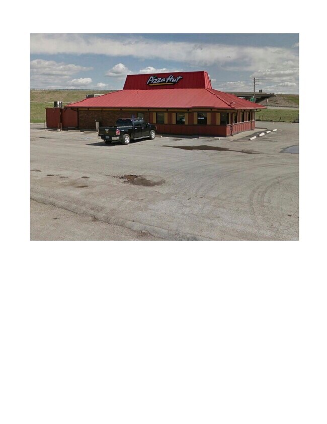
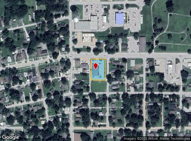
Property Record
125 E Main St, Osawatomie, KS 66064
NEARBY LISTINGS FOR SALE OR LEASE
Property Detail
125 E Main St
Kansas City, MO-KS
Roberts Addn Osawatomie
171-11-0-10-15-001.00-0
ROBERTS ADDN OSAWATOMIE, LTS 1-4-5-8 BLK 4 ROBERTS ADDN & TR BEG NW/C LT 1 TH N15 E142 S15 W142 TO POB SECTION 11 TOWNSHIP 18
Drugstorepharmacycvswalgreens
Miami
X
Kansas
20107C0050D
1-8
2025
0.65 AC
2025
Outer South Kansas City
100700
Kansas City
4,000 SF
DEMOGRAPHICS near 125 E Main St
1 Mile
3 Mile
5 Mile
2024 Total Population
3,040
5,879
7,345
2029 Population
3,239
6,227
7,755
Pop Growth 2024-2029
+ 6.55%
+ 5.92%
+ 5.58%
Average Age
36
39
40
2024 Total Households
1,110
2,201
2,772
HH Growth 2024-2029
+ 6.67%
+ 6.09%
+ 5.74%
Median Household Inc
$44,455
$58,728
$61,990
Avg Household Size
2.60
2.50
2.50
2024 Avg HH Vehicles
2.00
2.00
2.00
Median Home Value
$65,528
$107,044
$136,923
Median Year Built
1948
1955
1960
Nearby Places
Map Layers
Map Styles
 Street
 Aerial
- Restaurants
- Banks
- Shops
- Fitness
- Groceries
SALE & LEASE HISTORY
LISTING DATE
SALE/LEASE

May 08, 2023
For Sale
Feb 22, 2018
For Sale
Nearby Properties
Address
Land Use
TOTAL SIZE
Lot Size
Zoning
Address
Land Use
TOTAL SIZE
Lot Size
Zoning
87,635 SF
29.72 AC
Address
Land Use
TOTAL SIZE
Lot Size
Zoning
62,038 SF
37.29 AC
Address
Land Use
TOTAL SIZE
Lot Size
Zoning
1,761 SF
136.32 AC
BP
Address
Land Use
TOTAL SIZE
Lot Size
Zoning
39,026 SF
1.57 AC
Address
Land Use
TOTAL SIZE
Lot Size
Zoning
8,464 SF
4 AC
Address
Land Use
TOTAL SIZE
Lot Size
Zoning
Address
Land Use
TOTAL SIZE
Lot Size
Zoning
8,019 SF
3.08 AC
Address
Land Use
TOTAL SIZE
Lot Size
Zoning
9,345 SF
21.49 AC
Address
Land Use
TOTAL SIZE
Lot Size
Zoning
6,000 SF
3.45 AC
FEMA
Address
Land Use
TOTAL SIZE
Lot Size
Zoning
2,135 SF
0.49 AC
Address
Land Use
TOTAL SIZE
Lot Size
Zoning
924 SF
13.87 AC
FEMA
Address
Land Use
TOTAL SIZE
Lot Size
Zoning
7,481 SF
0.99 AC
Address
Land Use
TOTAL SIZE
Lot Size
Zoning
6,215 SF
0.76 AC
Address
Land Use
TOTAL SIZE
Lot Size
Zoning
6,149 SF
0.50 AC
Address
Land Use
TOTAL SIZE
Lot Size
Zoning
540 SF
2.04 AC
Address
Land Use
TOTAL SIZE
Lot Size
Zoning
10,492 SF
0.50 AC
Address
Land Use
TOTAL SIZE
Lot Size
Zoning
1,132 SF
3.93 AC
OGA
Address
Land Use
TOTAL SIZE
Lot Size
Zoning
9,000 SF
0.65 AC
Address
Land Use
TOTAL SIZE
Lot Size
Zoning
2,400 SF
0.34 AC
Address
Land Use
TOTAL SIZE
Lot Size
Zoning
4,068 SF
0.33 AC
Address
Land Use
TOTAL SIZE
Lot Size
Zoning
8,825 SF
0.72 AC
Address
Land Use
TOTAL SIZE
Lot Size
Zoning
4,070 SF
0.33 AC
Address
Land Use
TOTAL SIZE
Lot Size
Zoning
21,617 SF
5.83 AC
Address
Land Use
TOTAL SIZE
Lot Size
Zoning
2,048 SF
1.77 AC
OGA
Address
Land Use
TOTAL SIZE
Lot Size
Zoning
3,072 SF
0.33 AC
Address
Land Use
TOTAL SIZE
Lot Size
Zoning
1,548 SF
21.48 AC
Address
Land Use
TOTAL SIZE
Lot Size
Zoning
7,200 SF
0.21 AC
Address
Land Use
TOTAL SIZE
Lot Size
Zoning
33.12 AC
Address
Land Use
TOTAL SIZE
Lot Size
Zoning
9,354 SF
1.36 AC
Address
Land Use
TOTAL SIZE
Lot Size
Zoning
3,818 SF
0.25 AC
The World's #1 Commercial Real Estate Marketplace
Connect with us
© 2025 CoStar Group
The information above has been obtained from sources believed reliable. While we do not doubt its accuracy we have not verified it and make no guarantee, warranty or representation about it. It is your responsibility to independently confirm its accuracy and completeness. Any projections, opinions, assumptions, or estimates used are for example only and do not represent the current or future performance of the property. The value of this transaction to you depends on tax and other factors which should be evaluated by your tax, financial, and legal advisors. You and your advisors should conduct a careful, independent investigation of the property to determine to your satisfaction the suitability of the property for your needs.