Property Record
125 Easy St, Wenatchee, WA 98801
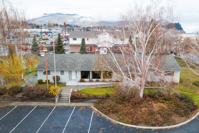

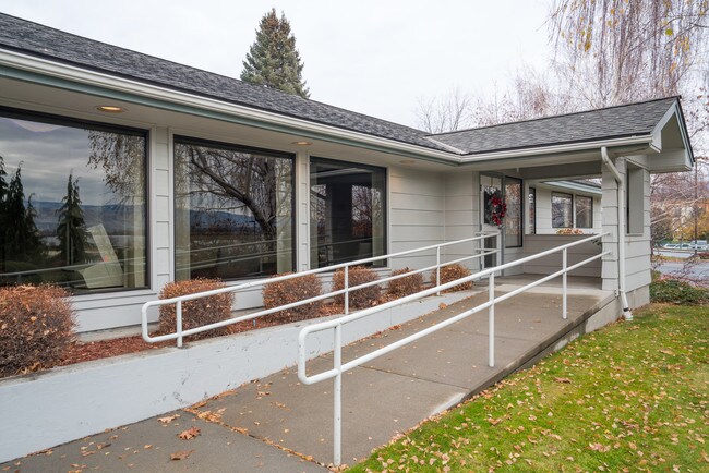

Property Detail
125 Easy St
Wenatchee-East Wenatchee, WA
T 23N R 20EWM S 28 PARCEL 2 SS#2205 1.0500 ACRES PARCEL 2 SS#2205
25143
CHELAN
Charitableorganization
Washington
2025
2
2025
1.05 AC
960700
Washington State Area
2,875 SF
Other Market Areas
NEARBY LISTINGS FOR SALE OR LEASE
DEMOGRAPHICS near 125 Easy St
1 mile
3 mile
5 mile
2025 Total Population
2,100
28,440
60,629
2030 Population
2,151
29,045
61,777
Pop Growth 2025-2030
+ 2.43%
+ 2.13%
+ 1.89%
Average Age
43
42
40
2025 Total Households
779
11,113
22,825
HH Growth 2025-2030
+ 2.44%
+ 1.98%
+ 1.84%
Median Household Inc
$102,339
$87,063
$81,347
Avg Household Size
2.60
2.50
2.60
2025 Avg HH Vehicles
2.00
2.00
2.00
Median Home Value
$572,917
$520,951
$468,092
Median Year Built
1991
1989
1979
Nearby Places
Map Layers
Map Styles
 Street
 Aerial
Layers
 Traffic
 Biking
Places
Listings with unknown addresses are not visible on the map
- Restaurants
- Banks
- Shops
- Fitness
- Groceries
PUBLIC TRANSPORTATION
COMMUTER RAIL
Wenatchee Amtrak (Empire Builder - Amtrak)
Drive
Walk
Distance
Wenatchee Amtrak (Empire Builder - Amtrak)
10 min
3.7 mi
AIRPORT
Pangborn Memorial
Drive
Walk
Distance
Pangborn Memorial
23 min
11.3 mi
Freight Ports
Port of Everett
Drive
Walk
Distance
Port of Everett
171 min
121.9 mi
SALE & LEASE HISTORY
LISTING DATE
SALE/LEASE

May 30, 2019
For Sale
Dec 17, 2018
For Sale
Nearby Properties
Address
Land Use
TOTAL SIZE
Lot Size
Zoning
Address
Land Use
TOTAL SIZE
Lot Size
Zoning
309,324 SF
6.84 AC
Address
Land Use
TOTAL SIZE
Lot Size
Zoning
419,838 SF
14.62 AC
Address
Land Use
TOTAL SIZE
Lot Size
Zoning
375,726 SF
30.12 AC
Address
Land Use
TOTAL SIZE
Lot Size
Zoning
198,833 SF
9.52 AC
Address
Land Use
TOTAL SIZE
Lot Size
Zoning
116,060 SF
6.44 AC
Address
Land Use
TOTAL SIZE
Lot Size
Zoning
149,177 SF
2.55 AC
Address
Land Use
TOTAL SIZE
Lot Size
Zoning
134,669 SF
7.63 AC
Address
Land Use
TOTAL SIZE
Lot Size
Zoning
197,755 SF
8.35 AC
R-M
Address
Land Use
TOTAL SIZE
Lot Size
Zoning
104,070 SF
3.11 AC
Address
Land Use
TOTAL SIZE
Lot Size
Zoning
111,946 SF
2 AC
Address
Land Use
TOTAL SIZE
Lot Size
Zoning
56,645 SF
6.35 AC
Address
Land Use
TOTAL SIZE
Lot Size
Zoning
73,830 SF
6.29 AC
Address
Land Use
TOTAL SIZE
Lot Size
Zoning
91,804 SF
10.26 AC
Address
Land Use
TOTAL SIZE
Lot Size
Zoning
159,039 SF
16.21 AC
Address
Land Use
TOTAL SIZE
Lot Size
Zoning
108,000 SF
7.05 AC
Address
Land Use
TOTAL SIZE
Lot Size
Zoning
109,475 SF
9 AC
Address
Land Use
TOTAL SIZE
Lot Size
Zoning
168,028 SF
21.20 AC
Address
Land Use
TOTAL SIZE
Lot Size
Zoning
57,520 SF
3.52 AC
Address
Land Use
TOTAL SIZE
Lot Size
Zoning
67,932 SF
5.58 AC
Address
Land Use
TOTAL SIZE
Lot Size
Zoning
42,032 SF
4.27 AC
Address
Land Use
TOTAL SIZE
Lot Size
Zoning
148,977 SF
11.06 AC
Address
Land Use
TOTAL SIZE
Lot Size
Zoning
142,150 SF
10.46 AC
Address
Land Use
TOTAL SIZE
Lot Size
Zoning
56,105 SF
6.03 AC
Address
Land Use
TOTAL SIZE
Lot Size
Zoning
89,736 SF
6.96 AC
Address
Land Use
TOTAL SIZE
Lot Size
Zoning
97,509 SF
5.71 AC
Address
Land Use
TOTAL SIZE
Lot Size
Zoning
870 SF
3.72 AC
Address
Land Use
TOTAL SIZE
Lot Size
Zoning
47,774 SF
5.02 AC
Address
Land Use
TOTAL SIZE
Lot Size
Zoning
61,000 SF
4.98 AC
Address
Land Use
TOTAL SIZE
Lot Size
Zoning
30,075 SF
5.82 AC
Address
Land Use
TOTAL SIZE
Lot Size
Zoning
18,128 SF
1.60 AC
The World's #1 Commercial Real Estate Marketplace
Connect with us
© 2026 CoStar Group
The information above has been obtained from sources believed reliable. While we do not doubt its accuracy we have not verified it and make no guarantee, warranty or representation about it. It is your responsibility to independently confirm its accuracy and completeness. Any projections, opinions, assumptions, or estimates used are for example only and do not represent the current or future performance of the property. The value of this transaction to you depends on tax and other factors which should be evaluated by your tax, financial, and legal advisors. You and your advisors should conduct a careful, independent investigation of the property to determine to your satisfaction the suitability of the property for your needs.