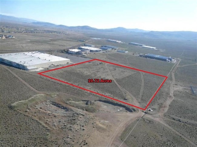
Property Record
125 Evans Ave, Dayton, NV 89403

Property Detail
125 Evans Ave
Reno, NV
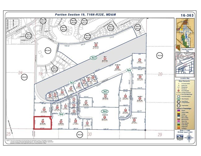
PAR 4-B
016-364-26
LYON
Industrialacreage
Nevada
ME
3-b
B and X Area of moderate flood hazard, usually the area between the limits of the 100-year and 500-year floods.
10.72 AC
2026
Lyon County
2025
Reno/Sparks
9603031001
NEARBY LISTINGS FOR SALE OR LEASE
DEMOGRAPHICS near 125 Evans Ave
1 mile
3 mile
5 mile
2025 Total Population
1,181
8,504
13,595
2030 Population
1,240
8,944
14,309
Pop Growth 2025-2030
+ 5.00%
+ 5.17%
+ 5.25%
Average Age
48
45
44
2025 Total Households
500
3,436
5,347
HH Growth 2025-2030
+ 5.00%
+ 5.12%
+ 5.18%
Median Household Inc
$93,243
$91,444
$91,294
Avg Household Size
2.40
2.50
2.50
2025 Avg HH Vehicles
2.00
2.00
2.00
Median Home Value
$492,622
$446,105
$431,526
Median Year Built
2001
2000
2000
Nearby Places
Map Layers
Map Styles
 Street
 Aerial
Transit
 Traffic
 Biking
Places
Listings with unknown addresses are not visible on the map
- Restaurants
- Banks
- Shops
- Fitness
- Groceries
PUBLIC TRANSPORTATION
AIRPORT
Reno/Tahoe International
Drive
Walk
Distance
Reno/Tahoe International
72 min
43.3 mi
Freight Ports
Port of Stockton
Drive
Walk
Distance
Port of Stockton
241 min
165.0 mi
SALE & LEASE HISTORY
LISTING DATE
SALE/LEASE

Sep 24, 2016
For Sale
Nearby Properties
Address
Land Use
TOTAL SIZE
Lot Size
Zoning
Address
Land Use
TOTAL SIZE
Lot Size
Zoning
619,375 SF
42.46 AC
ME
Address
Land Use
TOTAL SIZE
Lot Size
Zoning
350,286 SF
14.77 AC
ME
Address
Land Use
TOTAL SIZE
Lot Size
Zoning
32,460 SF
37.48 AC
RR5
Address
Land Use
TOTAL SIZE
Lot Size
Zoning
9,804 SF
3.31 AC
MFR
Address
Land Use
TOTAL SIZE
Lot Size
Zoning
184,000 SF
16.63 AC
ME
Address
Land Use
TOTAL SIZE
Lot Size
Zoning
64,532 SF
7 AC
C2
Address
Land Use
TOTAL SIZE
Lot Size
Zoning
144,761 SF
11.73 AC
ME
Address
Land Use
TOTAL SIZE
Lot Size
Zoning
38,576 SF
80.45 AC
RR5
Address
Land Use
TOTAL SIZE
Lot Size
Zoning
104,928 SF
10 AC
ME
Address
Land Use
TOTAL SIZE
Lot Size
Zoning
1,579 SF
6.73 AC
C2
Address
Land Use
TOTAL SIZE
Lot Size
Zoning
19,934 SF
2.18 AC
C2
Address
Land Use
TOTAL SIZE
Lot Size
Zoning
105,645 SF
6.33 AC
ME
Address
Land Use
TOTAL SIZE
Lot Size
Zoning
20,100 SF
6.58 AC
C1
Address
Land Use
TOTAL SIZE
Lot Size
Zoning
21,119 SF
3.10 AC
C2
Address
Land Use
TOTAL SIZE
Lot Size
Zoning
2,989 SF
3.21 AC
C2
Address
Land Use
TOTAL SIZE
Lot Size
Zoning
15,264 SF
1.60 AC
C2
Address
Land Use
TOTAL SIZE
Lot Size
Zoning
60,610 SF
6 AC
ME
Address
Land Use
TOTAL SIZE
Lot Size
Zoning
9,880 SF
2.31 AC
NR2
Address
Land Use
TOTAL SIZE
Lot Size
Zoning
3,600 SF
56.13 AC
MULT
Address
Land Use
TOTAL SIZE
Lot Size
Zoning
358.71 AC
CR
Address
Land Use
TOTAL SIZE
Lot Size
Zoning
37,992 SF
5.03 AC
ME
Address
Land Use
TOTAL SIZE
Lot Size
Zoning
21,349 SF
1.82 AC
C2
Address
Land Use
TOTAL SIZE
Lot Size
Zoning
672 SF
5.37 AC
C2
Address
Land Use
TOTAL SIZE
Lot Size
Zoning
42.04 AC
C2
Address
Land Use
TOTAL SIZE
Lot Size
Zoning
15,773 SF
1.80 AC
NR1
Address
Land Use
TOTAL SIZE
Lot Size
Zoning
18,456 SF
1.35 AC
C2
Address
Land Use
TOTAL SIZE
Lot Size
Zoning
15,543 SF
1.44 AC
C2
Address
Land Use
TOTAL SIZE
Lot Size
Zoning
47,273 SF
6.26 AC
ME
Address
Land Use
TOTAL SIZE
Lot Size
Zoning
12,644 SF
0.37 AC
C2
The World's #1 Commercial Real Estate Marketplace
Connect with us
© 2026 CoStar Group
The information above has been obtained from sources believed reliable. While we do not doubt its accuracy we have not verified it and make no guarantee, warranty or representation about it. It is your responsibility to independently confirm its accuracy and completeness. Any projections, opinions, assumptions, or estimates used are for example only and do not represent the current or future performance of the property. The value of this transaction to you depends on tax and other factors which should be evaluated by your tax, financial, and legal advisors. You and your advisors should conduct a careful, independent investigation of the property to determine to your satisfaction the suitability of the property for your needs.