Property Record
125 N Fm 511, Los Fresnos, TX 78566
NEARBY LISTINGS FOR SALE OR LEASE
Property Detail
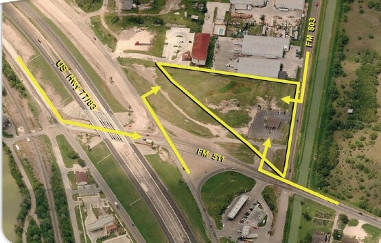
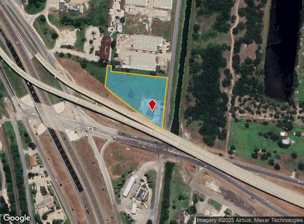
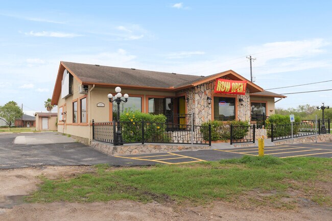
125 N Fm 511
Brownsville-Harlingen, TX
Olmito Original Townsite Groves
450100-0110-001000
OLMITO ORIGINAL TOWNSITE GROVES GROVE K BLK 117 & VACATED STREET, 2.5984 ACS OUT OF 3.772 ACRES
Commercialnec
Cameron
X
Texas
48061C0445F
10
2024
2.60 AC
2025
Outlying Cameron County
012202
Brownsville/Harlingen
2,984 SF
DEMOGRAPHICS near 125 N Fm 511
1 Mile
3 Mile
5 Mile
2024 Total Population
4,579
19,336
61,994
2029 Population
4,822
20,131
63,815
Pop Growth 2024-2029
+ 5.31%
+ 4.11%
+ 2.94%
Average Age
32
34
34
2024 Total Households
1,191
5,519
17,835
HH Growth 2024-2029
+ 5.88%
+ 4.33%
+ 2.99%
Median Household Inc
$65,988
$79,319
$68,717
Avg Household Size
3.40
3.30
3.40
2024 Avg HH Vehicles
2.00
2.00
2.00
Median Home Value
$167,579
$187,021
$159,494
Median Year Built
2008
2004
2001
Nearby Places
- Restaurants
- Banks
- Shops
- Fitness
- Groceries
PUBLIC TRANSPORTATION
AIRPORT
Brownsville/South Padre Island International
DRIVE
WALK
Distance
Brownsville/South Padre Island International
22 min
14.7 mi
Valley International
DRIVE
WALK
Distance
Valley International
24 min
18.4 mi
Freight Ports
Port of Brownsville
DRIVE
WALK
Distance
Port of Brownsville
15 min
12.4 mi
SALE & LEASE HISTORY
LISTING DATE
SALE/LEASE

Sep 24, 2016
For Sale
Aug 25, 2017
For Sale
Apr 23, 2024
For Sale
Nearby Properties
Address
Land Use
TOTAL SIZE
Lot Size
Zoning
Address
Land Use
TOTAL SIZE
Lot Size
Zoning
145,218 SF
23.16 AC
Address
Land Use
TOTAL SIZE
Lot Size
Zoning
72,320 SF
27.36 AC
Address
Land Use
TOTAL SIZE
Lot Size
Zoning
171,375 SF
8.99 AC
Address
Land Use
TOTAL SIZE
Lot Size
Zoning
155,855 SF
14.65 AC
C
Address
Land Use
TOTAL SIZE
Lot Size
Zoning
72,000 SF
5 AC
Address
Land Use
TOTAL SIZE
Lot Size
Zoning
80,493 SF
4.40 AC
Address
Land Use
TOTAL SIZE
Lot Size
Zoning
122,224 SF
9.93 AC
Address
Land Use
TOTAL SIZE
Lot Size
Zoning
121,377 SF
12.63 AC
Address
Land Use
TOTAL SIZE
Lot Size
Zoning
27,047 SF
1.93 AC
Address
Land Use
TOTAL SIZE
Lot Size
Zoning
29,370 SF
5.90 AC
Address
Land Use
TOTAL SIZE
Lot Size
Zoning
144,599 SF
20 AC
Address
Land Use
TOTAL SIZE
Lot Size
Zoning
48,488 SF
25.65 AC
Address
Land Use
TOTAL SIZE
Lot Size
Zoning
95,452 SF
19.94 AC
Address
Land Use
TOTAL SIZE
Lot Size
Zoning
6,084 SF
159.42 AC
Address
Land Use
TOTAL SIZE
Lot Size
Zoning
273.40 AC
Address
Land Use
TOTAL SIZE
Lot Size
Zoning
29,040 SF
3 AC
Address
Land Use
TOTAL SIZE
Lot Size
Zoning
3,942 SF
3.38 AC
Address
Land Use
TOTAL SIZE
Lot Size
Zoning
5,580 SF
1.38 AC
A-C
Address
Land Use
TOTAL SIZE
Lot Size
Zoning
47.25 AC
Address
Land Use
TOTAL SIZE
Lot Size
Zoning
44,700 SF
10 AC
Address
Land Use
TOTAL SIZE
Lot Size
Zoning
19,560 SF
0.82 AC
Address
Land Use
TOTAL SIZE
Lot Size
Zoning
24,730 SF
6.86 AC
Address
Land Use
TOTAL SIZE
Lot Size
Zoning
12,500 SF
21.37 AC
Address
Land Use
TOTAL SIZE
Lot Size
Zoning
Address
Land Use
TOTAL SIZE
Lot Size
Zoning
4,250 SF
2.70 AC
C
Address
Land Use
TOTAL SIZE
Lot Size
Zoning
22,514 SF
4 AC
Address
Land Use
TOTAL SIZE
Lot Size
Zoning
6,430 SF
1.58 AC
Address
Land Use
TOTAL SIZE
Lot Size
Zoning
7,308 SF
0.77 AC
C
Address
Land Use
TOTAL SIZE
Lot Size
Zoning
25,212 SF
8.01 AC
A-C
Address
Land Use
TOTAL SIZE
Lot Size
Zoning
25,023 SF
7.54 AC
A-C
The World's #1 Commercial Real Estate Marketplace
Connect with us
© 2025 CoStar Group
The information above has been obtained from sources believed reliable. While we do not doubt its accuracy we have not verified it and make no guarantee, warranty or representation about it. It is your responsibility to independently confirm its accuracy and completeness. Any projections, opinions, assumptions, or estimates used are for example only and do not represent the current or future performance of the property. The value of this transaction to you depends on tax and other factors which should be evaluated by your tax, financial, and legal advisors. You and your advisors should conduct a careful, independent investigation of the property to determine to your satisfaction the suitability of the property for your needs.