Property Record
125 Furrow Way, Alcoa, TN 37701
NEARBY LISTINGS FOR SALE OR LEASE
Property Detail
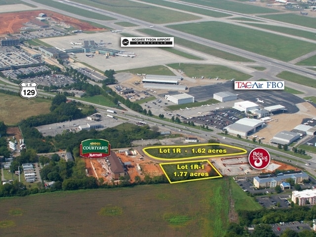
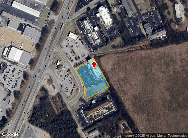
125 Furrow Way
Knoxville, TN
2306 Alcoa Highway
026N-A-021.00
2306 ALCOA HIGHWAY SD 1R1 2146A 2233B
Hotel
Blount
X
Tennessee
47009C0136C
1r1
0
1.77 AC
2025
Blount County
010200
Knoxville
40,231 SF
DEMOGRAPHICS near 125 Furrow Way
1 Mile
3 Mile
5 Mile
2024 Total Population
1,317
22,516
60,023
2029 Population
1,426
24,496
65,257
Pop Growth 2024-2029
+ 8.28%
+ 8.79%
+ 8.72%
Average Age
39
41
41
2024 Total Households
562
9,338
24,534
HH Growth 2024-2029
+ 8.36%
+ 8.79%
+ 8.77%
Median Household Inc
$70,219
$55,584
$57,707
Avg Household Size
2.30
2.40
2.30
2024 Avg HH Vehicles
2.00
2.00
2.00
Median Home Value
$153,009
$188,170
$213,704
Median Year Built
1947
1975
1979
Nearby Places
- Restaurants
- Banks
- Shops
- Fitness
- Groceries
PUBLIC TRANSPORTATION
AIRPORT
McGhee Tyson
DRIVE
WALK
Distance
McGhee Tyson
7 min
3.5 mi
Freight Ports
Georgia Ports - Savannah
DRIVE
WALK
Distance
Georgia Ports - Savannah
496 min
422.3 mi
Nearby Properties
Address
Land Use
TOTAL SIZE
Lot Size
Zoning
Address
Land Use
TOTAL SIZE
Lot Size
Zoning
2,612,320 SF
84.53 AC
S
Address
Land Use
TOTAL SIZE
Lot Size
Zoning
1,401.64 AC
AIR
Address
Land Use
TOTAL SIZE
Lot Size
Zoning
635,728 SF
234.46 AC
I
Address
Land Use
TOTAL SIZE
Lot Size
Zoning
222.60 AC
G
Address
Land Use
TOTAL SIZE
Lot Size
Zoning
29,040 SF
8.91 AC
G
Address
Land Use
TOTAL SIZE
Lot Size
Zoning
75,124 SF
9.11 AC
E
Address
Land Use
TOTAL SIZE
Lot Size
Zoning
46.37 AC
AIR
Address
Land Use
TOTAL SIZE
Lot Size
Zoning
144,298 SF
4.51 AC
G
Address
Land Use
TOTAL SIZE
Lot Size
Zoning
52,476 SF
20.82 AC
S
Address
Land Use
TOTAL SIZE
Lot Size
Zoning
150,532 SF
5.41 AC
G
Address
Land Use
TOTAL SIZE
Lot Size
Zoning
477.90 AC
I
Address
Land Use
TOTAL SIZE
Lot Size
Zoning
26,024 SF
16.24 AC
C
Address
Land Use
TOTAL SIZE
Lot Size
Zoning
29,765 SF
14.67 AC
E
Address
Land Use
TOTAL SIZE
Lot Size
Zoning
64,033 SF
5.65 AC
O-3
Address
Land Use
TOTAL SIZE
Lot Size
Zoning
258,532 SF
20 AC
O3
Address
Land Use
TOTAL SIZE
Lot Size
Zoning
158,466 SF
14.78 AC
E1
Address
Land Use
TOTAL SIZE
Lot Size
Zoning
18,936 SF
19.66 AC
I
Address
Land Use
TOTAL SIZE
Lot Size
Zoning
9,040 SF
27.85 AC
OS
Address
Land Use
TOTAL SIZE
Lot Size
Zoning
15,340 SF
5 AC
F
Address
Land Use
TOTAL SIZE
Lot Size
Zoning
172.05 AC
G
Address
Land Use
TOTAL SIZE
Lot Size
Zoning
86.20 AC
F
Address
Land Use
TOTAL SIZE
Lot Size
Zoning
60,328 SF
4.41 AC
F
Address
Land Use
TOTAL SIZE
Lot Size
Zoning
96,738 SF
23.34 AC
F
Address
Land Use
TOTAL SIZE
Lot Size
Zoning
21,350 SF
7.89 AC
E1
Address
Land Use
TOTAL SIZE
Lot Size
Zoning
236,656 SF
24.69 AC
E1
Address
Land Use
TOTAL SIZE
Lot Size
Zoning
175,681 SF
AIR
Address
Land Use
TOTAL SIZE
Lot Size
Zoning
33,414 SF
6.86 AC
E1
Address
Land Use
TOTAL SIZE
Lot Size
Zoning
68,180 SF
35.92 AC
AIR
Address
Land Use
TOTAL SIZE
Lot Size
Zoning
68,441 SF
0.17 AC
R
Address
Land Use
TOTAL SIZE
Lot Size
Zoning
53,524 SF
6.95 AC
C
The World's #1 Commercial Real Estate Marketplace
Connect with us
© 2025 CoStar Group
The information above has been obtained from sources believed reliable. While we do not doubt its accuracy we have not verified it and make no guarantee, warranty or representation about it. It is your responsibility to independently confirm its accuracy and completeness. Any projections, opinions, assumptions, or estimates used are for example only and do not represent the current or future performance of the property. The value of this transaction to you depends on tax and other factors which should be evaluated by your tax, financial, and legal advisors. You and your advisors should conduct a careful, independent investigation of the property to determine to your satisfaction the suitability of the property for your needs.