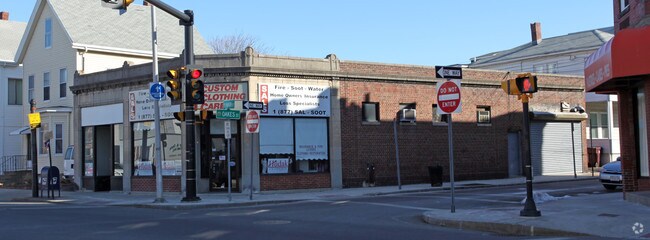
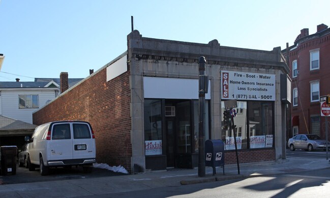
Property Record
125 Main St, Reading, MA 01867
NEARBY LISTINGS FOR SALE OR LEASE
Property Detail
125 Main St
Officebuilding
Middlesex
X
Massachusetts
25017C0313F
1.18 AC
2025
Somerville/Everett
2025
Boston
364101
Boston-Cambridge-Newton, MA-NH
23,382 SF
READ-000007-000000-000119
DEMOGRAPHICS near 125 Main St
1 Mile
3 Mile
5 Mile
2024 Total Population
36,146
356,140
789,597
2029 Population
34,812
342,787
765,619
Pop Growth 2024-2029
(3.69%)
(3.75%)
(3.04%)
Average Age
37
38
38
2024 Total Households
13,422
144,602
328,586
HH Growth 2024-2029
(3.54%)
(3.78%)
(3.12%)
Median Household Inc
$77,013
$90,411
$97,304
Avg Household Size
2.60
2.40
2.20
2024 Avg HH Vehicles
1.00
1.00
1.00
Median Home Value
$618,013
$681,954
$754,988
Median Year Built
1947
1949
1949
Nearby Places
Map Layers
Map Styles
 Street
 Aerial
- Restaurants
- Banks
- Shops
- Fitness
- Groceries
PUBLIC TRANSPORTATION
COMMUTER RAIL
Reading (Haverhill Line - Massachusetts Bay Transportation Authority Commuter Rail (Purple Line))
DRIVE
WALK
Distance
Reading (Haverhill Line - Massachusetts Bay Transportation Authority Commuter Rail (Purple Line))
3 min
1.2 mi
Wakefield (Haverhill Line - Massachusetts Bay Transportation Authority Commuter Rail (Purple Line))
DRIVE
WALK
Distance
Wakefield (Haverhill Line - Massachusetts Bay Transportation Authority Commuter Rail (Purple Line))
4 min
1.9 mi
AIRPORT
General Edward Lawrence Logan International
DRIVE
WALK
Distance
General Edward Lawrence Logan International
23 min
13.9 mi
Manchester Boston Regional
DRIVE
WALK
Distance
Manchester Boston Regional
57 min
40.7 mi
SALE & LEASE HISTORY
LISTING DATE
SALE/LEASE

Nov 14, 2020
For Lease
Nearby Properties
Address
Land Use
TOTAL SIZE
Lot Size
Zoning
Address
Land Use
TOTAL SIZE
Lot Size
Zoning
42.20 AC
S-2
Address
Land Use
TOTAL SIZE
Lot Size
Zoning
14.97 AC
C
Address
Land Use
TOTAL SIZE
Lot Size
Zoning
476,332 SF
5.37 AC
Address
Land Use
TOTAL SIZE
Lot Size
Zoning
411,956 SF
23.94 AC
S20
Address
Land Use
TOTAL SIZE
Lot Size
Zoning
213,401 SF
15.16 AC
B
Address
Land Use
TOTAL SIZE
Lot Size
Zoning
720 SF
632 AC
SA8
Address
Land Use
TOTAL SIZE
Lot Size
Zoning
31.56 AC
HB
Address
Land Use
TOTAL SIZE
Lot Size
Zoning
9.01 AC
S-I
Address
Land Use
TOTAL SIZE
Lot Size
Zoning
341,593 SF
3.38 AC
I-P2
Address
Land Use
TOTAL SIZE
Lot Size
Zoning
129,028 SF
7.17 AC
I-P2
Address
Land Use
TOTAL SIZE
Lot Size
Zoning
153,906 SF
4 AC
S15
Address
Land Use
TOTAL SIZE
Lot Size
Zoning
27.90 AC
I-P2
Address
Land Use
TOTAL SIZE
Lot Size
Zoning
228,797 SF
10.61 AC
MD
Address
Land Use
TOTAL SIZE
Lot Size
Zoning
172,056 SF
I
Address
Land Use
TOTAL SIZE
Lot Size
Zoning
17.65 AC
B-I
Address
Land Use
TOTAL SIZE
Lot Size
Zoning
10.73 AC
I-P2
Address
Land Use
TOTAL SIZE
Lot Size
Zoning
5.63 AC
C
Address
Land Use
TOTAL SIZE
Lot Size
Zoning
8.17 AC
RB
Address
Land Use
TOTAL SIZE
Lot Size
Zoning
6.28 AC
RB
Address
Land Use
TOTAL SIZE
Lot Size
Zoning
216,337 SF
7.19 AC
S20
Address
Land Use
TOTAL SIZE
Lot Size
Zoning
141,968 SF
11.28 AC
R20
Address
Land Use
TOTAL SIZE
Lot Size
Zoning
9 AC
C/R
Address
Land Use
TOTAL SIZE
Lot Size
Zoning
6.77 AC
I-P2
Address
Land Use
TOTAL SIZE
Lot Size
Zoning
14,760 SF
1 AC
SR
Address
Land Use
TOTAL SIZE
Lot Size
Zoning
481,812 SF
25.97 AC
I-P2
Address
Land Use
TOTAL SIZE
Lot Size
Zoning
62,853 SF
17.32 AC
R-2
Address
Land Use
TOTAL SIZE
Lot Size
Zoning
107,759 SF
22.42 AC
R-1
Address
Land Use
TOTAL SIZE
Lot Size
Zoning
11.06 AC
RB
Address
Land Use
TOTAL SIZE
Lot Size
Zoning
155,686 SF
2.88 AC
I
Address
Land Use
TOTAL SIZE
Lot Size
Zoning
5.91 AC
I-P2
The World's #1 Commercial Real Estate Marketplace
Connect with us
© 2026 CoStar Group
The information above has been obtained from sources believed reliable. While we do not doubt its accuracy we have not verified it and make no guarantee, warranty or representation about it. It is your responsibility to independently confirm its accuracy and completeness. Any projections, opinions, assumptions, or estimates used are for example only and do not represent the current or future performance of the property. The value of this transaction to you depends on tax and other factors which should be evaluated by your tax, financial, and legal advisors. You and your advisors should conduct a careful, independent investigation of the property to determine to your satisfaction the suitability of the property for your needs.