Property Record
125 Main St, Hull, MA 02045
Property Detail
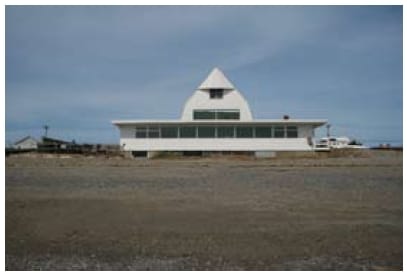
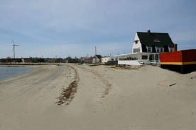
125 Main St
Restaurantbuilding
Plymouth
CRC
Massachusetts
AE The base floodplain where base flood elevations are provided. AE Zones are now used on new format FIRMs instead of A1-A30 Zones.
0.64 AC
2025
Route 3 Corridor
2025
Boston
500101
Boston-Cambridge-Newton, MA-NH
4,018 SF
HULL-000002-000000-000006
NEARBY LISTINGS FOR SALE OR LEASE
-
-
View all Hull listings for sale on LoopNet.com
DEMOGRAPHICS near 125 Main St
1 mile
3 mile
5 mile
2025 Total Population
1,173
8,563
46,900
2030 Population
1,236
8,947
48,251
Pop Growth 2025-2030
+ 5.37%
+ 4.48%
+ 2.88%
Average Age
51
48
45
2025 Total Households
512
3,772
19,964
HH Growth 2025-2030
+ 5.47%
+ 4.43%
+ 2.94%
Median Household Inc
$154,496
$120,867
$120,326
Avg Household Size
2.30
2.20
2.30
2025 Avg HH Vehicles
2.00
2.00
2.00
Median Home Value
$713,826
$704,104
$744,815
Median Year Built
1949
1948
1954
Nearby Places
Map Layers
Map Styles
 Street
 Aerial
Transit
 Traffic
 Biking
Places
Listings with unknown addresses are not visible on the map
- Restaurants
- Banks
- Shops
- Fitness
- Groceries
PUBLIC TRANSPORTATION
COMMUTER RAIL
Nantasket Junction (Greenbush Line - Massachusetts Bay Transportation Authority Commuter Rail (Purple Line))
Drive
Walk
Distance
Nantasket Junction (Greenbush Line - Massachusetts Bay Transportation Authority Commuter Rail (Purple Line))
14 min
6.9 mi
West Hingham (Greenbush Line - Massachusetts Bay Transportation Authority Commuter Rail (Purple Line))
Drive
Walk
Distance
West Hingham (Greenbush Line - Massachusetts Bay Transportation Authority Commuter Rail (Purple Line))
17 min
8.6 mi
AIRPORT
General Edward Lawrence Logan International
Drive
Walk
Distance
General Edward Lawrence Logan International
47 min
25.0 mi
Freight Ports
Port of Boston
Drive
Walk
Distance
Port of Boston
44 min
22.8 mi
Nearby Properties
Address
Land Use
TOTAL SIZE
Lot Size
Zoning
Address
Land Use
TOTAL SIZE
Lot Size
Zoning
106,581 SF
8.40 AC
POS
Address
Land Use
TOTAL SIZE
Lot Size
Zoning
149,190 SF
10.04 AC
POS
Address
Land Use
TOTAL SIZE
Lot Size
Zoning
61,014 SF
1.25 AC
POS
Address
Land Use
TOTAL SIZE
Lot Size
Zoning
12.64 AC
POS
Address
Land Use
TOTAL SIZE
Lot Size
Zoning
944 SF
6.05 AC
POS
Address
Land Use
TOTAL SIZE
Lot Size
Zoning
11,120 SF
35.30 AC
OS
Address
Land Use
TOTAL SIZE
Lot Size
Zoning
18.42 AC
POS
Address
Land Use
TOTAL SIZE
Lot Size
Zoning
50,775 SF
1.12 AC
BUS
Address
Land Use
TOTAL SIZE
Lot Size
Zoning
7,452 SF
4.25 AC
SFB
Address
Land Use
TOTAL SIZE
Lot Size
Zoning
20.31 AC
Address
Land Use
TOTAL SIZE
Lot Size
Zoning
30,946 SF
0.80 AC
BUS
Address
Land Use
TOTAL SIZE
Lot Size
Zoning
2,000 SF
3.43 AC
CRC
Address
Land Use
TOTAL SIZE
Lot Size
Zoning
55.83 AC
E
Address
Land Use
TOTAL SIZE
Lot Size
Zoning
28 AC
E
Address
Land Use
TOTAL SIZE
Lot Size
Zoning
3.15 AC
POS
Address
Land Use
TOTAL SIZE
Lot Size
Zoning
10,518 SF
0.64 AC
SFA
Address
Land Use
TOTAL SIZE
Lot Size
Zoning
12,696 SF
3.56 AC
POS
Address
Land Use
TOTAL SIZE
Lot Size
Zoning
4.04 AC
Address
Land Use
TOTAL SIZE
Lot Size
Zoning
16 AC
SFB
Address
Land Use
TOTAL SIZE
Lot Size
Zoning
5,354 SF
0.13 AC
SFA
Address
Land Use
TOTAL SIZE
Lot Size
Zoning
2.73 AC
CRC
Address
Land Use
TOTAL SIZE
Lot Size
Zoning
20,708 SF
1.17 AC
BUS
Address
Land Use
TOTAL SIZE
Lot Size
Zoning
9,555 SF
0.62 AC
SFA
Address
Land Use
TOTAL SIZE
Lot Size
Zoning
13,964 SF
0.84 AC
SFA
Address
Land Use
TOTAL SIZE
Lot Size
Zoning
11.44 AC
E
Address
Land Use
TOTAL SIZE
Lot Size
Zoning
11,412 SF
0.23 AC
BUS
Address
Land Use
TOTAL SIZE
Lot Size
Zoning
15,784 SF
0.38 AC
SFA
Address
Land Use
TOTAL SIZE
Lot Size
Zoning
7,296 SF
0.20 AC
BUS
Address
Land Use
TOTAL SIZE
Lot Size
Zoning
3,000 SF
0.28 AC
SFB
Address
Land Use
TOTAL SIZE
Lot Size
Zoning
4.61 AC
BUSB
The World's #1 Commercial Real Estate Marketplace
Connect with us
© 2026 CoStar Group
The information above has been obtained from sources believed reliable. While we do not doubt its accuracy we have not verified it and make no guarantee, warranty or representation about it. It is your responsibility to independently confirm its accuracy and completeness. Any projections, opinions, assumptions, or estimates used are for example only and do not represent the current or future performance of the property. The value of this transaction to you depends on tax and other factors which should be evaluated by your tax, financial, and legal advisors. You and your advisors should conduct a careful, independent investigation of the property to determine to your satisfaction the suitability of the property for your needs.