Property Record
125 Main St, Mantua, NJ 08051


Save to a Folder
{{folder.Name}}
{{folder.ListingIds.length}} Properties
{{folder.ListingIds.length}} Property
Create a New Folder
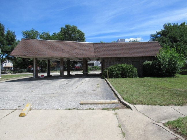
Property Detail
125 Main St
10-00096-0000-00013
14,15,16 & 18
Officebuilding
Gloucester
NC
New Jersey
B and X Area of moderate flood hazard, usually the area between the limits of the 100-year and 500-year floods.
13
2025
0.73 AC
2026
Gloucester County
500702
Philadelphia
864 SF
Philadelphia-Camden-Wilmington, PA-NJ-DE-MD
NEARBY LISTINGS FOR SALE OR LEASE
DEMOGRAPHICS near 125 Main St
1 mile
3 mile
5 mile
2025 Total Population
8,979
46,509
126,973
2030 Population
9,235
47,639
130,272
Pop Growth 2025-2030
+ 2.85%
+ 2.43%
+ 2.60%
Average Age
42
41
42
2025 Total Households
3,640
17,981
48,769
HH Growth 2025-2030
+ 2.91%
+ 2.48%
+ 2.63%
Median Household Inc
$109,939
$104,992
$98,460
Avg Household Size
2.40
2.50
2.50
2025 Avg HH Vehicles
2.00
2.00
2.00
Median Home Value
$291,321
$326,763
$319,343
Median Year Built
1982
1977
1976
Nearby Places
Map Layers
Map Styles
 Street
 Aerial
Layers
 Traffic
 Biking
Places
Listings with unknown addresses are not visible on the map
- Restaurants
- Banks
- Shops
- Fitness
- Groceries
PUBLIC TRANSPORTATION
AIRPORT
Philadelphia International
Drive
Walk
Distance
Philadelphia International
35 min
19.0 mi
Trenton Mercer
Drive
Walk
Distance
Trenton Mercer
69 min
46.2 mi
Atlantic City International
Drive
Walk
Distance
Atlantic City International
81 min
47.2 mi
Freight Ports
Broadway Terminal - Pier 5
Drive
Walk
Distance
Broadway Terminal - Pier 5
19 min
9.0 mi
SALE & LEASE HISTORY
LISTING DATE
SALE/LEASE

Sep 23, 2016
For Sale
Sep 01, 2017
For Sale
Nearby Properties
Address
Land Use
TOTAL SIZE
Lot Size
Zoning
Address
Land Use
TOTAL SIZE
Lot Size
Zoning
228.36 AC
INS
Address
Land Use
TOTAL SIZE
Lot Size
Zoning
22.60 AC
R4
Address
Land Use
TOTAL SIZE
Lot Size
Zoning
32.64 AC
INS
Address
Land Use
TOTAL SIZE
Lot Size
Zoning
38.17 AC
R4
Address
Land Use
TOTAL SIZE
Lot Size
Zoning
35.50 AC
R4
Address
Land Use
TOTAL SIZE
Lot Size
Zoning
Address
Land Use
TOTAL SIZE
Lot Size
Zoning
32.20 AC
R-1
Address
Land Use
TOTAL SIZE
Lot Size
Zoning
63.46 AC
INS
Address
Land Use
TOTAL SIZE
Lot Size
Zoning
21.16 AC
INS
Address
Land Use
TOTAL SIZE
Lot Size
Zoning
24.27 AC
M2
Address
Land Use
TOTAL SIZE
Lot Size
Zoning
3.22 AC
PA
Address
Land Use
TOTAL SIZE
Lot Size
Zoning
14.11 AC
SC
Address
Land Use
TOTAL SIZE
Lot Size
Zoning
19.34 AC
R1
Address
Land Use
TOTAL SIZE
Lot Size
Zoning
15.98 AC
PC
Address
Land Use
TOTAL SIZE
Lot Size
Zoning
111.40 AC
RRC
Address
Land Use
TOTAL SIZE
Lot Size
Zoning
4.47 AC
MU
Address
Land Use
TOTAL SIZE
Lot Size
Zoning
12.14 AC
Address
Land Use
TOTAL SIZE
Lot Size
Zoning
7.01 AC
R11
Address
Land Use
TOTAL SIZE
Lot Size
Zoning
8.89 AC
Address
Land Use
TOTAL SIZE
Lot Size
Zoning
34.49 AC
M1
Address
Land Use
TOTAL SIZE
Lot Size
Zoning
14.14 AC
R11
Address
Land Use
TOTAL SIZE
Lot Size
Zoning
12.73 AC
Address
Land Use
TOTAL SIZE
Lot Size
Zoning
28.70 AC
M1
Address
Land Use
TOTAL SIZE
Lot Size
Zoning
2.62 AC
Address
Land Use
TOTAL SIZE
Lot Size
Zoning
Address
Land Use
TOTAL SIZE
Lot Size
Zoning
21.26 AC
M1
Address
Land Use
TOTAL SIZE
Lot Size
Zoning
27.40 AC
LI
Address
Land Use
TOTAL SIZE
Lot Size
Zoning
7.81 AC
M1
Address
Land Use
TOTAL SIZE
Lot Size
Zoning
13,221 SF
9.92 AC
HC
Address
Land Use
TOTAL SIZE
Lot Size
Zoning
The World's #1 Commercial Real Estate Marketplace
Connect with us
© 2026 CoStar Group
The information above has been obtained from sources believed reliable. While we do not doubt its accuracy we have not verified it and make no guarantee, warranty or representation about it. It is your responsibility to independently confirm its accuracy and completeness. Any projections, opinions, assumptions, or estimates used are for example only and do not represent the current or future performance of the property. The value of this transaction to you depends on tax and other factors which should be evaluated by your tax, financial, and legal advisors. You and your advisors should conduct a careful, independent investigation of the property to determine to your satisfaction the suitability of the property for your needs.