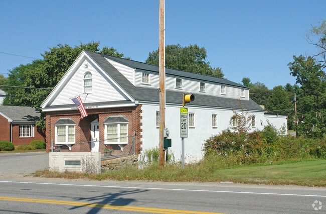
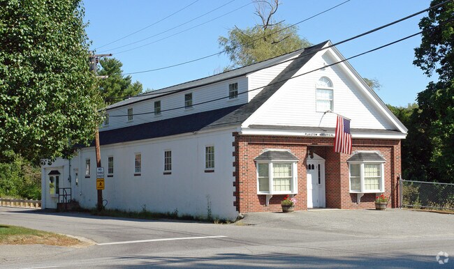
Property Record
125 Main St, Salem, NH 03079
NEARBY LISTINGS FOR SALE OR LEASE
Property Detail
125 Main St
Financialbuilding
Rockingham
AE
New Hampshire
25009C0075F
2 AC
2024
Rockingham
2024
Boston
067503
Boston-Cambridge-Newton, MA-NH
5,108 SF
SLEM-000089-001252
DEMOGRAPHICS near 125 Main St
1 Mile
3 Mile
5 Mile
2024 Total Population
3,363
21,173
82,256
2029 Population
3,487
21,470
82,318
Pop Growth 2024-2029
+ 3.69%
+ 1.40%
+ 0.08%
Average Age
43
44
41
2024 Total Households
1,334
8,307
32,309
HH Growth 2024-2029
+ 3.67%
+ 1.25%
0.00%
Median Household Inc
$99,338
$107,526
$84,812
Avg Household Size
2.50
2.50
2.50
2024 Avg HH Vehicles
2.00
2.00
2.00
Median Home Value
$392,796
$397,042
$403,254
Median Year Built
1968
1976
1971
Nearby Places
Map Layers
Map Styles
 Street
 Aerial
- Restaurants
- Banks
- Shops
- Fitness
- Groceries
PUBLIC TRANSPORTATION
COMMUTER RAIL
Lawrence (Haverhill Line - Massachusetts Bay Transportation Authority Commuter Rail (Purple Line))
DRIVE
WALK
Distance
Lawrence (Haverhill Line - Massachusetts Bay Transportation Authority Commuter Rail (Purple Line))
19 min
6.6 mi
Haverhill (Haverhill Line - Massachusetts Bay Transportation Authority Commuter Rail (Purple Line))
DRIVE
WALK
Distance
Haverhill (Haverhill Line - Massachusetts Bay Transportation Authority Commuter Rail (Purple Line))
18 min
8.2 mi
AIRPORT
Manchester Boston Regional
DRIVE
WALK
Distance
Manchester Boston Regional
31 min
22.4 mi
Freight Ports
Port of Boston
DRIVE
WALK
Distance
Port of Boston
1 min
32.0 mi
Nearby Properties
Address
Land Use
TOTAL SIZE
Lot Size
Zoning
Address
Land Use
TOTAL SIZE
Lot Size
Zoning
555,715 SF
32.40 AC
CIC
Address
Land Use
TOTAL SIZE
Lot Size
Zoning
306,500 SF
8.31 AC
CIC
Address
Land Use
TOTAL SIZE
Lot Size
Zoning
48.22 AC
TCD
Address
Land Use
TOTAL SIZE
Lot Size
Zoning
8.37 AC
CIC
Address
Land Use
TOTAL SIZE
Lot Size
Zoning
39.80 AC
CIC
Address
Land Use
TOTAL SIZE
Lot Size
Zoning
273,035 SF
7.70 AC
CIC
Address
Land Use
TOTAL SIZE
Lot Size
Zoning
23.55 AC
CIC
Address
Land Use
TOTAL SIZE
Lot Size
Zoning
75.16 AC
CIB
Address
Land Use
TOTAL SIZE
Lot Size
Zoning
137,886 SF
26.65 AC
CIC
Address
Land Use
TOTAL SIZE
Lot Size
Zoning
168,870 SF
4.35 AC
CIC
Address
Land Use
TOTAL SIZE
Lot Size
Zoning
20.17 AC
CIC
Address
Land Use
TOTAL SIZE
Lot Size
Zoning
205,043 SF
24.10 AC
CIC
Address
Land Use
TOTAL SIZE
Lot Size
Zoning
72.18 AC
CIB
Address
Land Use
TOTAL SIZE
Lot Size
Zoning
297,592 SF
2.90 AC
CIC
Address
Land Use
TOTAL SIZE
Lot Size
Zoning
181,956 SF
19.79 AC
CIC
Address
Land Use
TOTAL SIZE
Lot Size
Zoning
225,000 SF
1.62 AC
CIC
Address
Land Use
TOTAL SIZE
Lot Size
Zoning
7.99 AC
CIB
Address
Land Use
TOTAL SIZE
Lot Size
Zoning
215,338 SF
66.52 AC
CIB
Address
Land Use
TOTAL SIZE
Lot Size
Zoning
91,266 SF
26 AC
RUR
Address
Land Use
TOTAL SIZE
Lot Size
Zoning
173,760 SF
16.48 AC
CIC
Address
Land Use
TOTAL SIZE
Lot Size
Zoning
12.10 AC
CIC
Address
Land Use
TOTAL SIZE
Lot Size
Zoning
164,772 SF
11.91 AC
CIC
Address
Land Use
TOTAL SIZE
Lot Size
Zoning
137,420 SF
15 AC
TCD
Address
Land Use
TOTAL SIZE
Lot Size
Zoning
72,936 SF
5.50 AC
TCD
Address
Land Use
TOTAL SIZE
Lot Size
Zoning
50,048 SF
8.81 AC
CIB
Address
Land Use
TOTAL SIZE
Lot Size
Zoning
32,949 SF
5.98 AC
CIC
Address
Land Use
TOTAL SIZE
Lot Size
Zoning
113,388 SF
16.28 AC
CIB
Address
Land Use
TOTAL SIZE
Lot Size
Zoning
185,496 SF
11.99 AC
CIC
Address
Land Use
TOTAL SIZE
Lot Size
Zoning
Address
Land Use
TOTAL SIZE
Lot Size
Zoning
21.88 AC
CIC
The World's #1 Commercial Real Estate Marketplace
Connect with us
© 2026 CoStar Group
The information above has been obtained from sources believed reliable. While we do not doubt its accuracy we have not verified it and make no guarantee, warranty or representation about it. It is your responsibility to independently confirm its accuracy and completeness. Any projections, opinions, assumptions, or estimates used are for example only and do not represent the current or future performance of the property. The value of this transaction to you depends on tax and other factors which should be evaluated by your tax, financial, and legal advisors. You and your advisors should conduct a careful, independent investigation of the property to determine to your satisfaction the suitability of the property for your needs.