Property Record
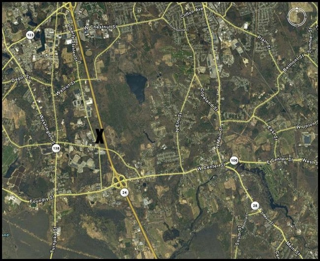
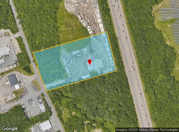
125 Manley St, West Bridgewater, MA 02379
NEARBY LISTINGS FOR SALE OR LEASE
-
-
View all West Bridgewater listings for sale on LoopNet.com
Property Detail
125 Manley St
WBRI-000029-000000-000002
Plymouth
Industrialgeneral
Massachusetts
X
2
25023C0168J
6.84 AC
2025
Route 3 South
2025
Boston
524101
Boston-Cambridge-Newton, MA-NH
4,500 SF
DEMOGRAPHICS near 125 Manley St
1 Mile
3 Mile
5 Mile
2024 Total Population
1,649
19,440
114,757
2029 Population
1,650
19,365
113,865
Pop Growth 2024-2029
+ 0.06%
(0.39%)
(0.78%)
Average Age
42
42
39
2024 Total Households
679
7,198
38,732
HH Growth 2024-2029
+ 0.15%
(0.44%)
(0.75%)
Median Household Inc
$89,722
$104,924
$88,341
Avg Household Size
2.40
2.60
2.70
2024 Avg HH Vehicles
2.00
2.00
2.00
Median Home Value
$412,406
$437,920
$433,409
Median Year Built
1977
1967
1964
Nearby Places
Map Layers
Map Styles
 Street
 Aerial
- Restaurants
- Banks
- Shops
- Fitness
- Groceries
PUBLIC TRANSPORTATION
COMMUTER RAIL
Campello (Middleborough/Lakeville Line - Massachusetts Bay Transportation Authority Commuter Rail (Purple Line))
DRIVE
WALK
Distance
Campello (Middleborough/Lakeville Line - Massachusetts Bay Transportation Authority Commuter Rail (Purple Line))
11 min
5.1 mi
Brockton (Middleborough/Lakeville Line - Massachusetts Bay Transportation Authority Commuter Rail (Purple Line))
DRIVE
WALK
Distance
Brockton (Middleborough/Lakeville Line - Massachusetts Bay Transportation Authority Commuter Rail (Purple Line))
13 min
5.6 mi
AIRPORT
General Edward Lawrence Logan International
DRIVE
WALK
Distance
General Edward Lawrence Logan International
44 min
30.9 mi
Rhode Island Tf Green International
DRIVE
WALK
Distance
Rhode Island Tf Green International
61 min
35.2 mi
Freight Ports
Port of Boston
DRIVE
WALK
Distance
Port of Boston
42 min
28.7 mi
Nearby Properties
Address
Land Use
TOTAL SIZE
Lot Size
Zoning
Address
Land Use
TOTAL SIZE
Lot Size
Zoning
Address
Land Use
TOTAL SIZE
Lot Size
Zoning
1,352 SF
66.81 AC
R1B
Address
Land Use
TOTAL SIZE
Lot Size
Zoning
349,800 SF
30.82 AC
Address
Land Use
TOTAL SIZE
Lot Size
Zoning
216,489 SF
49.60 AC
Address
Land Use
TOTAL SIZE
Lot Size
Zoning
223,200 SF
5.26 AC
C2
Address
Land Use
TOTAL SIZE
Lot Size
Zoning
21.12 AC
Address
Land Use
TOTAL SIZE
Lot Size
Zoning
130,640 SF
10.27 AC
R1C
Address
Land Use
TOTAL SIZE
Lot Size
Zoning
97,262 SF
6.46 AC
Address
Land Use
TOTAL SIZE
Lot Size
Zoning
558,011 SF
82.11 AC
Address
Land Use
TOTAL SIZE
Lot Size
Zoning
254,946 SF
11.22 AC
R2
Address
Land Use
TOTAL SIZE
Lot Size
Zoning
67.01 AC
Address
Land Use
TOTAL SIZE
Lot Size
Zoning
2,884 SF
3.18 AC
R2
Address
Land Use
TOTAL SIZE
Lot Size
Zoning
210,600 SF
19.86 AC
Address
Land Use
TOTAL SIZE
Lot Size
Zoning
647 SF
53.67 AC
I3
Address
Land Use
TOTAL SIZE
Lot Size
Zoning
1,576 SF
5.83 AC
C5
Address
Land Use
TOTAL SIZE
Lot Size
Zoning
312,000 SF
30.61 AC
Address
Land Use
TOTAL SIZE
Lot Size
Zoning
2,574 SF
7.96 AC
I1
Address
Land Use
TOTAL SIZE
Lot Size
Zoning
Address
Land Use
TOTAL SIZE
Lot Size
Zoning
211,030 SF
19.27 AC
Address
Land Use
TOTAL SIZE
Lot Size
Zoning
1,844 SF
14 AC
R1C
Address
Land Use
TOTAL SIZE
Lot Size
Zoning
80,429 SF
16.68 AC
Address
Land Use
TOTAL SIZE
Lot Size
Zoning
101,871 SF
82.25 AC
Address
Land Use
TOTAL SIZE
Lot Size
Zoning
44,138 SF
27.41 AC
Address
Land Use
TOTAL SIZE
Lot Size
Zoning
3,891 SF
7.19 AC
I1
Address
Land Use
TOTAL SIZE
Lot Size
Zoning
13.80 AC
I1
Address
Land Use
TOTAL SIZE
Lot Size
Zoning
15.90 AC
Address
Land Use
TOTAL SIZE
Lot Size
Zoning
40,755 SF
2.62 AC
Address
Land Use
TOTAL SIZE
Lot Size
Zoning
88,200 SF
8.98 AC
Address
Land Use
TOTAL SIZE
Lot Size
Zoning
1,666 SF
22.18 AC
I1
Address
Land Use
TOTAL SIZE
Lot Size
Zoning
1,904 SF
13.88 AC
R1B
The World's #1 Commercial Real Estate Marketplace
Connect with us
© 2025 CoStar Group
The information above has been obtained from sources believed reliable. While we do not doubt its accuracy we have not verified it and make no guarantee, warranty or representation about it. It is your responsibility to independently confirm its accuracy and completeness. Any projections, opinions, assumptions, or estimates used are for example only and do not represent the current or future performance of the property. The value of this transaction to you depends on tax and other factors which should be evaluated by your tax, financial, and legal advisors. You and your advisors should conduct a careful, independent investigation of the property to determine to your satisfaction the suitability of the property for your needs.