Property Record
125 N Lowell Rd, Windham, NH 03087


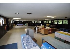
Property Detail
125 N Lowell Rd
WNDM-000002-A000000-000700
Rockingham
Religious
New Hampshire
MZ
700
B and X Area of moderate flood hazard, usually the area between the limits of the 100-year and 500-year floods.
35.26 AC
0
Rockingham
2025
Boston
106101
Boston-Cambridge-Newton, MA-NH
6,243 SF
NEARBY LISTINGS FOR SALE OR LEASE
DEMOGRAPHICS near 125 N Lowell Rd
1 mile
3 mile
5 mile
2025 Total Population
1,688
24,551
66,009
2030 Population
1,698
24,717
66,601
Pop Growth 2025-2030
+ 0.59%
+ 0.68%
+ 0.90%
Average Age
41
42
42
2025 Total Households
556
9,252
24,704
HH Growth 2025-2030
+ 0.54%
+ 0.55%
+ 0.75%
Median Household Inc
$171,308
$122,203
$122,073
Avg Household Size
2.90
2.60
2.60
2025 Avg HH Vehicles
2.00
2.00
2.00
Median Home Value
$644,396
$530,405
$528,540
Median Year Built
1987
1983
1982
Nearby Places
Map Layers
Map Styles
 Street
 Aerial
Layers
 Traffic
 Biking
Places
Listings with unknown addresses are not visible on the map
- Restaurants
- Banks
- Shops
- Fitness
- Groceries
PUBLIC TRANSPORTATION
AIRPORT
Manchester Boston Regional
Drive
Walk
Distance
Manchester Boston Regional
30 min
14.5 mi
General Edward Lawrence Logan International
Drive
Walk
Distance
General Edward Lawrence Logan International
56 min
41.3 mi
Portsmouth International at Pease
Drive
Walk
Distance
Portsmouth International at Pease
67 min
49.8 mi
Freight Ports
Port of Boston
Drive
Walk
Distance
Port of Boston
57 min
41.0 mi
Nearby Properties
Address
Land Use
TOTAL SIZE
Lot Size
Zoning
Address
Land Use
TOTAL SIZE
Lot Size
Zoning
146,407 SF
15.39 AC
OMB
Address
Land Use
TOTAL SIZE
Lot Size
Zoning
12.73 AC
C-I
Address
Land Use
TOTAL SIZE
Lot Size
Zoning
30.26 AC
C-I
Address
Land Use
TOTAL SIZE
Lot Size
Zoning
108,248 SF
5.92 AC
OMB
Address
Land Use
TOTAL SIZE
Lot Size
Zoning
80,710 SF
20 AC
AR-I
Address
Land Use
TOTAL SIZE
Lot Size
Zoning
13,158 SF
52.40 AC
VCD
Address
Land Use
TOTAL SIZE
Lot Size
Zoning
71,854 SF
26 AC
RD
Address
Land Use
TOTAL SIZE
Lot Size
Zoning
60,572 SF
5.65 AC
C-I
Address
Land Use
TOTAL SIZE
Lot Size
Zoning
21,433 SF
7.54 AC
LID
Address
Land Use
TOTAL SIZE
Lot Size
Zoning
63,628 SF
34.21 AC
CDA
Address
Land Use
TOTAL SIZE
Lot Size
Zoning
58,449 SF
41.20 AC
RD
Address
Land Use
TOTAL SIZE
Lot Size
Zoning
59,626 SF
7.40 AC
VCD
Address
Land Use
TOTAL SIZE
Lot Size
Zoning
20,784 SF
15 AC
PBT
Address
Land Use
TOTAL SIZE
Lot Size
Zoning
59,544 SF
20.23 AC
C-II
Address
Land Use
TOTAL SIZE
Lot Size
Zoning
32.45 AC
C-II
Address
Land Use
TOTAL SIZE
Lot Size
Zoning
4.10 AC
MFR
Address
Land Use
TOTAL SIZE
Lot Size
Zoning
4.14 AC
MFR
Address
Land Use
TOTAL SIZE
Lot Size
Zoning
4 AC
MFR
Address
Land Use
TOTAL SIZE
Lot Size
Zoning
51,881 SF
12.01 AC
MDR
Address
Land Use
TOTAL SIZE
Lot Size
Zoning
13,673 SF
11.76 AC
CDA
Address
Land Use
TOTAL SIZE
Lot Size
Zoning
11,412 SF
4.21 AC
CDA
Address
Land Use
TOTAL SIZE
Lot Size
Zoning
3,556 SF
7.45 AC
RD
Address
Land Use
TOTAL SIZE
Lot Size
Zoning
26,262 SF
3.75 AC
CDA
Address
Land Use
TOTAL SIZE
Lot Size
Zoning
32,328 SF
2.43 AC
MFR
Address
Land Use
TOTAL SIZE
Lot Size
Zoning
7.21 AC
IND5
Address
Land Use
TOTAL SIZE
Lot Size
Zoning
25,560 SF
2 AC
MHDR
Address
Land Use
TOTAL SIZE
Lot Size
Zoning
25,560 SF
2.40 AC
MHDR
Address
Land Use
TOTAL SIZE
Lot Size
Zoning
31,896 SF
2.50 AC
MFR
Address
Land Use
TOTAL SIZE
Lot Size
Zoning
31,896 SF
1.81 AC
MFR
Address
Land Use
TOTAL SIZE
Lot Size
Zoning
31,896 SF
1.81 AC
MFR
The World's #1 Commercial Real Estate Marketplace
Connect with us
© 2026 CoStar Group
The information above has been obtained from sources believed reliable. While we do not doubt its accuracy we have not verified it and make no guarantee, warranty or representation about it. It is your responsibility to independently confirm its accuracy and completeness. Any projections, opinions, assumptions, or estimates used are for example only and do not represent the current or future performance of the property. The value of this transaction to you depends on tax and other factors which should be evaluated by your tax, financial, and legal advisors. You and your advisors should conduct a careful, independent investigation of the property to determine to your satisfaction the suitability of the property for your needs.