Property Record
125 Nicholson Rd, Winston Salem, NC 27107
NEARBY LISTINGS FOR SALE OR LEASE
-
-
View all Winston Salem listings for sale on LoopNet.com
Property Detail
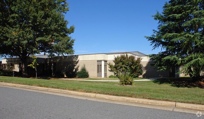
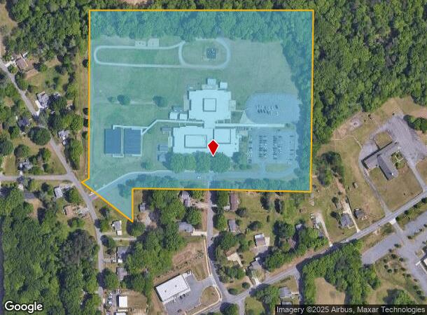
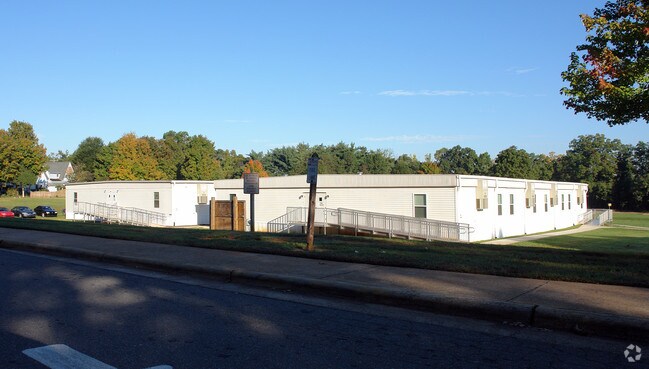
125 Nicholson Rd
Winston-Salem, NC
Hall Woodard Elementary School
6855-20-8233
HALL WOODARD ELEMENTARY SCHOOL LO:003A BL:2610 BU:1
Charitableorganization
Forsyth
AE
North Carolina
3710685500J
3a
0
18.93 AC
2025
SE Forsyth County
003309
Greensboro/Winston-Salem
1,518 SF
DEMOGRAPHICS near 125 Nicholson Rd
1 Mile
3 Mile
5 Mile
2024 Total Population
5,968
39,202
111,350
2029 Population
6,264
40,837
116,409
Pop Growth 2024-2029
+ 4.96%
+ 4.17%
+ 4.54%
Average Age
35
36
38
2024 Total Households
2,212
13,697
43,851
HH Growth 2024-2029
+ 5.06%
+ 4.19%
+ 4.66%
Median Household Inc
$42,644
$45,352
$47,428
Avg Household Size
2.60
2.60
2.40
2024 Avg HH Vehicles
2.00
2.00
2.00
Median Home Value
$163,844
$166,516
$177,150
Median Year Built
1987
1979
1977
Nearby Places
Map Layers
Map Styles
 Street
 Aerial
- Restaurants
- Banks
- Shops
- Fitness
- Groceries
PUBLIC TRANSPORTATION
AIRPORT
Piedmont Triad International
DRIVE
WALK
Distance
Piedmont Triad International
30 min
17.4 mi
Freight Ports
Virginia Port Authority - Richmond
DRIVE
WALK
Distance
Virginia Port Authority - Richmond
256 min
221.0 mi
Nearby Properties
Address
Land Use
TOTAL SIZE
Lot Size
Zoning
Address
Land Use
TOTAL SIZE
Lot Size
Zoning
505,696 SF
34.94 AC
LI-S
Address
Land Use
TOTAL SIZE
Lot Size
Zoning
188,273 SF
54.55 AC
IP
Address
Land Use
TOTAL SIZE
Lot Size
Zoning
200,340 SF
21.50 AC
LI-S
Address
Land Use
TOTAL SIZE
Lot Size
Zoning
1,182.87 AC
IP
Address
Land Use
TOTAL SIZE
Lot Size
Zoning
315,669 SF
28.73 AC
LI,LI-S
Address
Land Use
TOTAL SIZE
Lot Size
Zoning
415,099 SF
104.61 AC
LI,RS9
Address
Land Use
TOTAL SIZE
Lot Size
Zoning
72,617 SF
13.85 AC
RM18
Address
Land Use
TOTAL SIZE
Lot Size
Zoning
140,000 SF
11.17 AC
LI-S
Address
Land Use
TOTAL SIZE
Lot Size
Zoning
319,873 SF
35.01 AC
GI
Address
Land Use
TOTAL SIZE
Lot Size
Zoning
144,300 SF
21.12 AC
LI-S
Address
Land Use
TOTAL SIZE
Lot Size
Zoning
85,000 SF
48.02 AC
IP
Address
Land Use
TOTAL SIZE
Lot Size
Zoning
66,245 SF
12.60 AC
RM12
Address
Land Use
TOTAL SIZE
Lot Size
Zoning
157,878 SF
11 AC
GI
Address
Land Use
TOTAL SIZE
Lot Size
Zoning
225,955 SF
64.68 AC
LI
Address
Land Use
TOTAL SIZE
Lot Size
Zoning
141,089 SF
16.31 AC
GI
Address
Land Use
TOTAL SIZE
Lot Size
Zoning
125,130 SF
11.23 AC
LI
Address
Land Use
TOTAL SIZE
Lot Size
Zoning
105,828 SF
17.58 AC
LI,LI-S
Address
Land Use
TOTAL SIZE
Lot Size
Zoning
378,330 SF
74.78 AC
GI,GI-S,RS
Address
Land Use
TOTAL SIZE
Lot Size
Zoning
125,000 SF
10.61 AC
LI,LI-S
Address
Land Use
TOTAL SIZE
Lot Size
Zoning
100 SF
12.10 AC
RM8-S
Address
Land Use
TOTAL SIZE
Lot Size
Zoning
69,708 SF
16.10 AC
RM12
Address
Land Use
TOTAL SIZE
Lot Size
Zoning
367,405 SF
21.46 AC
GI
Address
Land Use
TOTAL SIZE
Lot Size
Zoning
49,396 SF
184.40 AC
GI-S,IP
Address
Land Use
TOTAL SIZE
Lot Size
Zoning
55,180 SF
17.35 AC
RM8-S
Address
Land Use
TOTAL SIZE
Lot Size
Zoning
73,868 SF
7.35 AC
IP
Address
Land Use
TOTAL SIZE
Lot Size
Zoning
32,220 SF
7.69 AC
LI,LI-S
Address
Land Use
TOTAL SIZE
Lot Size
Zoning
73,732 SF
8.05 AC
IP
Address
Land Use
TOTAL SIZE
Lot Size
Zoning
116,392 SF
30.06 AC
RM8
Address
Land Use
TOTAL SIZE
Lot Size
Zoning
40,944 SF
8.78 AC
RM18-S,RM8
Address
Land Use
TOTAL SIZE
Lot Size
Zoning
61,400 SF
14.38 AC
AG,GI-S
The World's #1 Commercial Real Estate Marketplace
Connect with us
© 2025 CoStar Group
The information above has been obtained from sources believed reliable. While we do not doubt its accuracy we have not verified it and make no guarantee, warranty or representation about it. It is your responsibility to independently confirm its accuracy and completeness. Any projections, opinions, assumptions, or estimates used are for example only and do not represent the current or future performance of the property. The value of this transaction to you depends on tax and other factors which should be evaluated by your tax, financial, and legal advisors. You and your advisors should conduct a careful, independent investigation of the property to determine to your satisfaction the suitability of the property for your needs.