Property Record
125 Packer Rd, Canterbury, CT 06331
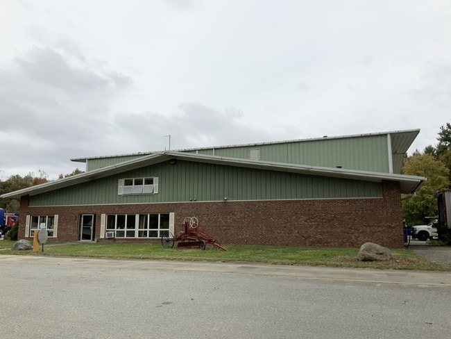

Property Detail
125 Packer Rd
CANT M:62 B:24
WINDHAM
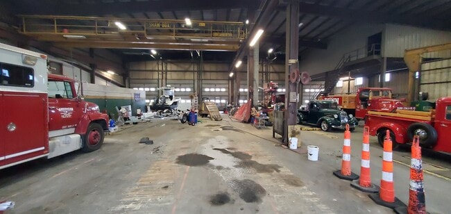
Commercialbuilding
Connecticut
2025
5.02 AC
2025
Windham County
906100
Hartford
21,000 SF
Willimantic, CT
NEARBY LISTINGS FOR SALE OR LEASE
DEMOGRAPHICS near 125 Packer Rd
1 mile
3 mile
5 mile
2025 Total Population
382
8,284
22,472
2030 Population
392
8,455
22,922
Pop Growth 2025-2030
+ 2.62%
+ 2.06%
+ 2.00%
Average Age
44
44
43
2025 Total Households
153
3,300
8,987
HH Growth 2025-2030
+ 2.61%
+ 2.18%
+ 2.06%
Median Household Inc
$82,670
$73,298
$76,531
Avg Household Size
2.50
2.50
2.50
2025 Avg HH Vehicles
2.00
2.00
2.00
Median Home Value
$258,333
$268,830
$278,119
Median Year Built
1966
1970
1971
Nearby Places
Map Layers
Map Styles
 Street
 Aerial
Layers
 Traffic
 Biking
Places
Listings with unknown addresses are not visible on the map
- Restaurants
- Banks
- Shops
- Fitness
- Groceries
PUBLIC TRANSPORTATION
AIRPORT
Rhode Island Tf Green International
Drive
Walk
Distance
Rhode Island Tf Green International
60 min
40.3 mi
Freight Ports
Port of Davisville, RI
Drive
Walk
Distance
Port of Davisville, RI
71 min
39.3 mi
SALE & LEASE HISTORY
LISTING DATE
SALE/LEASE

Sep 06, 2022
For Lease
Oct 17, 2019
For Lease
Nearby Properties
Address
Land Use
TOTAL SIZE
Lot Size
Zoning
Address
Land Use
TOTAL SIZE
Lot Size
Zoning
202.19 AC
IND
Address
Land Use
TOTAL SIZE
Lot Size
Zoning
202,044 SF
52.20 AC
I
Address
Land Use
TOTAL SIZE
Lot Size
Zoning
37.12 AC
RA60
Address
Land Use
TOTAL SIZE
Lot Size
Zoning
54,304 SF
28.41 AC
IND-2
Address
Land Use
TOTAL SIZE
Lot Size
Zoning
13,444 SF
10.94 AC
RA30
Address
Land Use
TOTAL SIZE
Lot Size
Zoning
Address
Land Use
TOTAL SIZE
Lot Size
Zoning
27,400 SF
4.34 AC
C2
Address
Land Use
TOTAL SIZE
Lot Size
Zoning
15.20 AC
C
Address
Land Use
TOTAL SIZE
Lot Size
Zoning
35,165 SF
6.63 AC
RA30
Address
Land Use
TOTAL SIZE
Lot Size
Zoning
800 SF
15.50 AC
Address
Land Use
TOTAL SIZE
Lot Size
Zoning
6.26 AC
C
Address
Land Use
TOTAL SIZE
Lot Size
Zoning
Address
Land Use
TOTAL SIZE
Lot Size
Zoning
34,830 SF
2.52 AC
C2
Address
Land Use
TOTAL SIZE
Lot Size
Zoning
80,180 SF
9.66 AC
IND-1
Address
Land Use
TOTAL SIZE
Lot Size
Zoning
10,937 SF
2.54 AC
C2
Address
Land Use
TOTAL SIZE
Lot Size
Zoning
11.40 AC
CI
Address
Land Use
TOTAL SIZE
Lot Size
Zoning
28,494 SF
6.67 AC
C2
Address
Land Use
TOTAL SIZE
Lot Size
Zoning
8.30 AC
RA30
Address
Land Use
TOTAL SIZE
Lot Size
Zoning
13,812 SF
1.70 AC
RA19
Address
Land Use
TOTAL SIZE
Lot Size
Zoning
26,796 SF
2.89 AC
I
Address
Land Use
TOTAL SIZE
Lot Size
Zoning
18,600 SF
2.50 AC
RA19
Address
Land Use
TOTAL SIZE
Lot Size
Zoning
12,692 SF
2.46 AC
C2
Address
Land Use
TOTAL SIZE
Lot Size
Zoning
134.78 AC
Address
Land Use
TOTAL SIZE
Lot Size
Zoning
52.63 AC
IND-1
Address
Land Use
TOTAL SIZE
Lot Size
Zoning
10,000 SF
6.25 AC
IND
Address
Land Use
TOTAL SIZE
Lot Size
Zoning
6,889 SF
1.04 AC
C
Address
Land Use
TOTAL SIZE
Lot Size
Zoning
5,508 SF
59.80 AC
C2
Address
Land Use
TOTAL SIZE
Lot Size
Zoning
27,060 SF
2.76 AC
C2
Address
Land Use
TOTAL SIZE
Lot Size
Zoning
44.90 AC
I
Address
Land Use
TOTAL SIZE
Lot Size
Zoning
1,642 SF
3.14 AC
RA30
The World's #1 Commercial Real Estate Marketplace
Connect with us
© 2026 CoStar Group
The information above has been obtained from sources believed reliable. While we do not doubt its accuracy we have not verified it and make no guarantee, warranty or representation about it. It is your responsibility to independently confirm its accuracy and completeness. Any projections, opinions, assumptions, or estimates used are for example only and do not represent the current or future performance of the property. The value of this transaction to you depends on tax and other factors which should be evaluated by your tax, financial, and legal advisors. You and your advisors should conduct a careful, independent investigation of the property to determine to your satisfaction the suitability of the property for your needs.