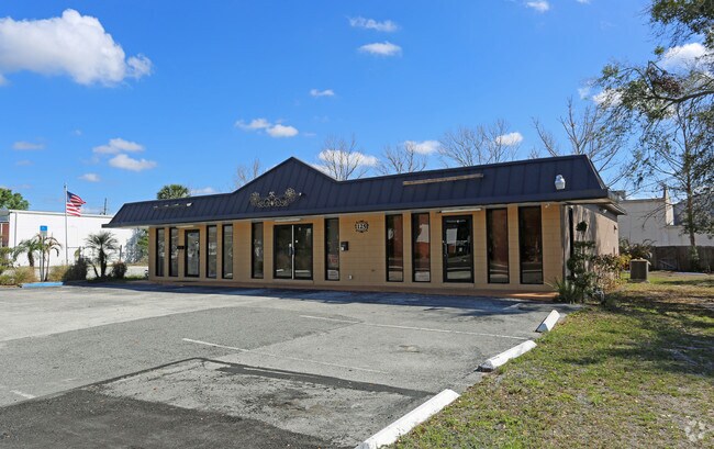
Property Record
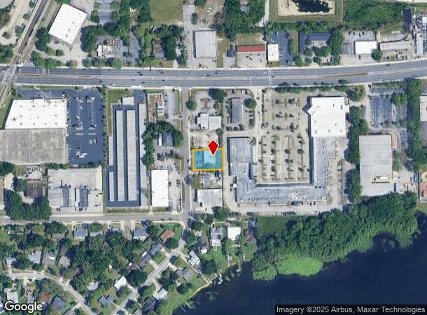
125 Robin Rd, Altamonte Springs, FL 32701


NEARBY LISTINGS FOR SALE OR LEASE
Property Detail
125 Robin Rd
Orlando-Kissimmee-Sanford, FL
Town And Country Estates Replat
18-21-30-514-0B00-0030
LOT 3 BLK B TOWN + COUNTRY ESTATES REPLAT PB 12 PG 29
Storemultistory
Seminole
X
Florida
12095C0165F
3
2024
0.34 AC
2024
Altamonte/Douglas
021802
Orlando
3,000 SF
DEMOGRAPHICS near 125 Robin Rd
1 Mile
3 Mile
5 Mile
2024 Total Population
8,678
94,340
255,466
2029 Population
9,058
98,364
266,081
Pop Growth 2024-2029
+ 4.38%
+ 4.27%
+ 4.16%
Average Age
41
42
41
2024 Total Households
3,712
40,486
107,174
HH Growth 2024-2029
+ 4.36%
+ 4.44%
+ 4.33%
Median Household Inc
$52,371
$60,158
$63,361
Avg Household Size
2.20
2.30
2.30
2024 Avg HH Vehicles
2.00
2.00
2.00
Median Home Value
$263,374
$293,958
$306,984
Median Year Built
1974
1978
1981
Nearby Places
Map Layers
Map Styles
 Street
 Aerial
- Restaurants
- Banks
- Shops
- Fitness
- Groceries
PUBLIC TRANSPORTATION
COMMUTER RAIL
DRIVE
WALK
Distance
2 min
7 min
0.4 mi
DRIVE
WALK
Distance
7 min
3.1 mi
AIRPORT
Orlando Sanford International
DRIVE
WALK
Distance
Orlando Sanford International
24 min
12.7 mi
Orlando International
DRIVE
WALK
Distance
Orlando International
31 min
17.6 mi
SALE & LEASE HISTORY
LISTING DATE
SALE/LEASE

Sep 25, 2016
For Lease
Nov 29, 2016
For Lease
Mar 01, 2018
For Lease
Mar 01, 2018
For Sale
Jun 05, 2025
For Lease
Nearby Properties
Address
Land Use
TOTAL SIZE
Lot Size
Zoning
Address
Land Use
TOTAL SIZE
Lot Size
Zoning
2,416 SF
29.71 AC
Address
Land Use
TOTAL SIZE
Lot Size
Zoning
88,256 SF
39.64 AC
MOC3
Address
Land Use
TOTAL SIZE
Lot Size
Zoning
423,270 SF
3.45 AC
MOC3
Address
Land Use
TOTAL SIZE
Lot Size
Zoning
21.25 AC
GC
Address
Land Use
TOTAL SIZE
Lot Size
Zoning
467,832 SF
20.10 AC
PD
Address
Land Use
TOTAL SIZE
Lot Size
Zoning
Address
Land Use
TOTAL SIZE
Lot Size
Zoning
1,158 SF
17.22 AC
Address
Land Use
TOTAL SIZE
Lot Size
Zoning
1,400 SF
31.20 AC
A1
Address
Land Use
TOTAL SIZE
Lot Size
Zoning
508,923 SF
41.05 AC
C2
Address
Land Use
TOTAL SIZE
Lot Size
Zoning
656,009 SF
5.59 AC
DM
Address
Land Use
TOTAL SIZE
Lot Size
Zoning
206 SF
1.43 AC
VMU
Address
Land Use
TOTAL SIZE
Lot Size
Zoning
563,546 SF
0.61 AC
DM
Address
Land Use
TOTAL SIZE
Lot Size
Zoning
555,833 SF
3.65 AC
DM
Address
Land Use
TOTAL SIZE
Lot Size
Zoning
400 SF
13.82 AC
R1AA
Address
Land Use
TOTAL SIZE
Lot Size
Zoning
5,256 SF
1.10 AC
PUDRES
Address
Land Use
TOTAL SIZE
Lot Size
Zoning
231,070 SF
35.59 AC
MOR2
Address
Land Use
TOTAL SIZE
Lot Size
Zoning
350,767 SF
11.12 AC
PUD
Address
Land Use
TOTAL SIZE
Lot Size
Zoning
456 SF
9.56 AC
Address
Land Use
TOTAL SIZE
Lot Size
Zoning
1,428 SF
8.56 AC
MOR3
Address
Land Use
TOTAL SIZE
Lot Size
Zoning
1,170 SF
17.75 AC
A1
Address
Land Use
TOTAL SIZE
Lot Size
Zoning
797,604 SF
3.31 AC
DM
Address
Land Use
TOTAL SIZE
Lot Size
Zoning
97,888 SF
3.72 AC
IND
Address
Land Use
TOTAL SIZE
Lot Size
Zoning
254,477 SF
13.14 AC
MOR2
Address
Land Use
TOTAL SIZE
Lot Size
Zoning
6,817 SF
19.83 AC
R3
Address
Land Use
TOTAL SIZE
Lot Size
Zoning
17,728 SF
14.64 AC
GC
Address
Land Use
TOTAL SIZE
Lot Size
Zoning
409,338 SF
27.27 AC
RSF-2
Address
Land Use
TOTAL SIZE
Lot Size
Zoning
254,371 SF
15.63 AC
R1A
Address
Land Use
TOTAL SIZE
Lot Size
Zoning
6,466 SF
18.97 AC
MOC3
Address
Land Use
TOTAL SIZE
Lot Size
Zoning
279,457 SF
20.56 AC
R3
Address
Land Use
TOTAL SIZE
Lot Size
Zoning
377,321 SF
20.58 AC
R3A
The World's #1 Commercial Real Estate Marketplace
Connect with us
© 2025 CoStar Group
The information above has been obtained from sources believed reliable. While we do not doubt its accuracy we have not verified it and make no guarantee, warranty or representation about it. It is your responsibility to independently confirm its accuracy and completeness. Any projections, opinions, assumptions, or estimates used are for example only and do not represent the current or future performance of the property. The value of this transaction to you depends on tax and other factors which should be evaluated by your tax, financial, and legal advisors. You and your advisors should conduct a careful, independent investigation of the property to determine to your satisfaction the suitability of the property for your needs.