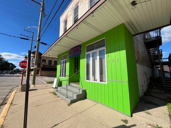
Property Record
125 N Main St, Burlington, IL 60109
Current Lease Availabilities
NEARBY LISTINGS FOR SALE OR LEASE
Property Detail
125 N Main St
04-10-102-005
Commercial
Commercialnec
Kane
X
Illinois
17089C0125H
1,2
2024
0.16 AC
2024
Western East/West Corr
850703
Chicago
4,511 SF
Chicago-Naperville-Elgin, IL-IN-WI
DEMOGRAPHICS near 125 N Main St
1 Mile
3 Mile
5 Mile
2024 Total Population
612
3,642
11,550
2029 Population
596
3,713
11,945
Pop Growth 2024-2029
(2.61%)
+ 1.95%
+ 3.42%
Average Age
44
40
40
2024 Total Households
246
1,316
4,241
HH Growth 2024-2029
(2.85%)
+ 1.67%
+ 3.30%
Median Household Inc
$95,607
$108,669
$103,319
Avg Household Size
2.50
2.80
2.70
2024 Avg HH Vehicles
2.00
3.00
2.00
Median Home Value
$368,965
$333,706
$331,951
Median Year Built
1972
1993
1999
Nearby Places
- Restaurants
- Banks
- Shops
- Fitness
- Groceries
PUBLIC TRANSPORTATION
AIRPORT
Chicago/Rockford International
DRIVE
WALK
Distance
Chicago/Rockford International
61 min
38.3 mi
Chicago O'Hare International
DRIVE
WALK
Distance
Chicago O'Hare International
75 min
45.1 mi
Nearby Properties
Address
Land Use
TOTAL SIZE
Lot Size
Zoning
Address
Land Use
TOTAL SIZE
Lot Size
Zoning
Address
Land Use
TOTAL SIZE
Lot Size
Zoning
55,292 SF
3.58 AC
Address
Land Use
TOTAL SIZE
Lot Size
Zoning
3.81 AC
Address
Land Use
TOTAL SIZE
Lot Size
Zoning
1.16 AC
Address
Land Use
TOTAL SIZE
Lot Size
Zoning
1.79 AC
Address
Land Use
TOTAL SIZE
Lot Size
Zoning
2,098 SF
100 AC
F DISTRICT
Address
Land Use
TOTAL SIZE
Lot Size
Zoning
3,151 SF
2.52 AC
B3 DISTRIC
Address
Land Use
TOTAL SIZE
Lot Size
Zoning
3,339 SF
0.95 AC
B2 DISTRIC
Address
Land Use
TOTAL SIZE
Lot Size
Zoning
Address
Land Use
TOTAL SIZE
Lot Size
Zoning
6,658 SF
1.48 AC
B2 DISTRIC
Address
Land Use
TOTAL SIZE
Lot Size
Zoning
9,399 SF
0.78 AC
Address
Land Use
TOTAL SIZE
Lot Size
Zoning
1 AC
LI DISTRIC
Address
Land Use
TOTAL SIZE
Lot Size
Zoning
2,800 SF
0.73 AC
B1 DISTRIC
Address
Land Use
TOTAL SIZE
Lot Size
Zoning
9,799 SF
1.50 AC
Address
Land Use
TOTAL SIZE
Lot Size
Zoning
0.53 AC
F1 RESTRIC
Address
Land Use
TOTAL SIZE
Lot Size
Zoning
3 AC
F DISTRICT
Address
Land Use
TOTAL SIZE
Lot Size
Zoning
10,387 SF
0.67 AC
B2 DISTRIC
Address
Land Use
TOTAL SIZE
Lot Size
Zoning
3,773 SF
2.23 AC
Address
Land Use
TOTAL SIZE
Lot Size
Zoning
2,773 SF
2.27 AC
B2 DISTRIC
Address
Land Use
TOTAL SIZE
Lot Size
Zoning
6,939 SF
0.20 AC
Address
Land Use
TOTAL SIZE
Lot Size
Zoning
3,186 SF
0.55 AC
R2 DISTRIC
Address
Land Use
TOTAL SIZE
Lot Size
Zoning
17.34 AC
Address
Land Use
TOTAL SIZE
Lot Size
Zoning
Address
Land Use
TOTAL SIZE
Lot Size
Zoning
Address
Land Use
TOTAL SIZE
Lot Size
Zoning
7,306 SF
0.10 AC
Address
Land Use
TOTAL SIZE
Lot Size
Zoning
1.47 AC
B1 DISTRIC
Address
Land Use
TOTAL SIZE
Lot Size
Zoning
1,563 SF
0.29 AC
R2 DISTRIC
Address
Land Use
TOTAL SIZE
Lot Size
Zoning
8,797 SF
0.59 AC
The World's #1 Commercial Real Estate Marketplace
Connect with us
© 2025 CoStar Group
The information above has been obtained from sources believed reliable. While we do not doubt its accuracy we have not verified it and make no guarantee, warranty or representation about it. It is your responsibility to independently confirm its accuracy and completeness. Any projections, opinions, assumptions, or estimates used are for example only and do not represent the current or future performance of the property. The value of this transaction to you depends on tax and other factors which should be evaluated by your tax, financial, and legal advisors. You and your advisors should conduct a careful, independent investigation of the property to determine to your satisfaction the suitability of the property for your needs.