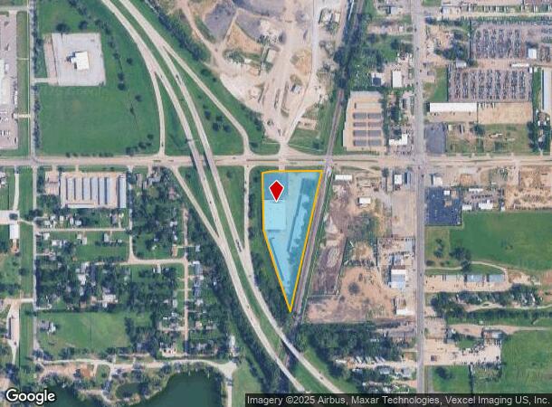
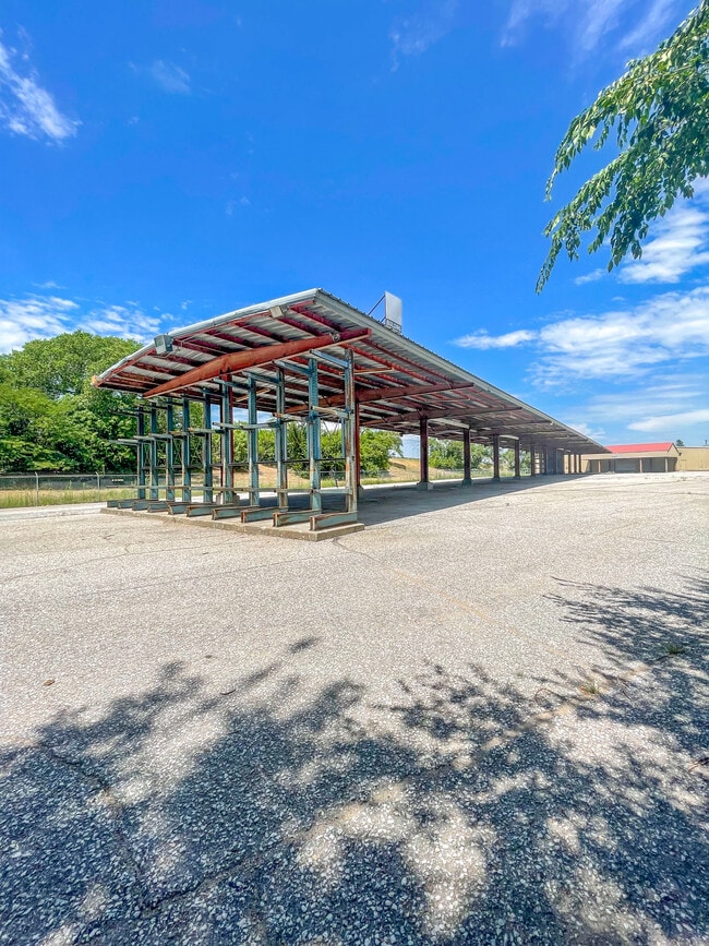
Property Record
125 W Macarthur Rd, Wichita, KS 67217

NEARBY LISTINGS FOR SALE OR LEASE
Property Detail
125 W Macarthur Rd
Wichita, KS
Don Schmid Add
214-17-0-11-02-001.00
LOT 1 BLOCK A DON SCHMID ADD
Warehouse
Sedgwick
X
Kansas
20173C0502G
1
2024
5.36 AC
2025
Southwest
005100
Wichita
59,684 SF
DEMOGRAPHICS near 125 W Macarthur Rd
1 Mile
3 Mile
5 Mile
2024 Total Population
5,054
72,764
151,595
2029 Population
5,148
74,642
155,913
Pop Growth 2024-2029
+ 1.86%
+ 2.58%
+ 2.85%
Average Age
38
37
37
2024 Total Households
1,998
28,164
60,545
HH Growth 2024-2029
+ 1.70%
+ 2.53%
+ 2.90%
Median Household Inc
$42,218
$44,105
$44,462
Avg Household Size
2.30
2.50
2.40
2024 Avg HH Vehicles
2.00
2.00
2.00
Median Home Value
$94,885
$85,650
$92,094
Median Year Built
1959
1966
1961
Nearby Places
Map Layers
Map Styles
 Street
 Aerial
- Restaurants
- Banks
- Shops
- Fitness
- Groceries
PUBLIC TRANSPORTATION
AIRPORT
Wichita Dwight D Eisenhower Ntl
DRIVE
WALK
Distance
Wichita Dwight D Eisenhower Ntl
17 min
10.2 mi
SALE & LEASE HISTORY
LISTING DATE
SALE/LEASE

Nov 11, 2022
For Lease
Aug 18, 2023
For Sale
Nearby Properties
Address
Land Use
TOTAL SIZE
Lot Size
Zoning
Address
Land Use
TOTAL SIZE
Lot Size
Zoning
431,634 SF
74.68 AC
AA
Address
Land Use
TOTAL SIZE
Lot Size
Zoning
379,016 SF
35.45 AC
SF-5
Address
Land Use
TOTAL SIZE
Lot Size
Zoning
233,806 SF
54.14 AC
LC
Address
Land Use
TOTAL SIZE
Lot Size
Zoning
233,436 SF
20.38 AC
LI
Address
Land Use
TOTAL SIZE
Lot Size
Zoning
62,580 SF
7.83 AC
SF20
Address
Land Use
TOTAL SIZE
Lot Size
Zoning
211,379 SF
23.34 AC
SF-5
Address
Land Use
TOTAL SIZE
Lot Size
Zoning
67,145 SF
11.49 AC
LI
Address
Land Use
TOTAL SIZE
Lot Size
Zoning
79,955 SF
7.05 AC
SF-5
Address
Land Use
TOTAL SIZE
Lot Size
Zoning
134,475 SF
19.87 AC
LI
Address
Land Use
TOTAL SIZE
Lot Size
Zoning
63,908 SF
25.58 AC
SF-5
Address
Land Use
TOTAL SIZE
Lot Size
Zoning
119,245 SF
10.77 AC
MF29
Address
Land Use
TOTAL SIZE
Lot Size
Zoning
72,114 SF
47.10 AC
SF-5
Address
Land Use
TOTAL SIZE
Lot Size
Zoning
71,651 SF
5.82 AC
SF-5
Address
Land Use
TOTAL SIZE
Lot Size
Zoning
91,734 SF
16.30 AC
SF-5
Address
Land Use
TOTAL SIZE
Lot Size
Zoning
75,932 SF
5.46 AC
SF-5
Address
Land Use
TOTAL SIZE
Lot Size
Zoning
120,398 SF
8.38 AC
PUD
Address
Land Use
TOTAL SIZE
Lot Size
Zoning
35,528 SF
7.15 AC
LC
Address
Land Use
TOTAL SIZE
Lot Size
Zoning
67,479 SF
0.74 AC
B
Address
Land Use
TOTAL SIZE
Lot Size
Zoning
44,467 SF
4.51 AC
B
Address
Land Use
TOTAL SIZE
Lot Size
Zoning
59,964 SF
16.85 AC
LI,LC
Address
Land Use
TOTAL SIZE
Lot Size
Zoning
53,626 SF
8.03 AC
SF-5
Address
Land Use
TOTAL SIZE
Lot Size
Zoning
58,144 SF
18.57 AC
SF-5
Address
Land Use
TOTAL SIZE
Lot Size
Zoning
90,654 SF
6.36 AC
LC
Address
Land Use
TOTAL SIZE
Lot Size
Zoning
64,377 SF
4.82 AC
SF-5
Address
Land Use
TOTAL SIZE
Lot Size
Zoning
40,926 SF
5.21 AC
LI
Address
Land Use
TOTAL SIZE
Lot Size
Zoning
31,440 SF
21.30 AC
SF-5
Address
Land Use
TOTAL SIZE
Lot Size
Zoning
42,983 SF
5.67 AC
SF-5
Address
Land Use
TOTAL SIZE
Lot Size
Zoning
43,349 SF
0.67 AC
SF-5
The World's #1 Commercial Real Estate Marketplace
Connect with us
© 2025 CoStar Group
The information above has been obtained from sources believed reliable. While we do not doubt its accuracy we have not verified it and make no guarantee, warranty or representation about it. It is your responsibility to independently confirm its accuracy and completeness. Any projections, opinions, assumptions, or estimates used are for example only and do not represent the current or future performance of the property. The value of this transaction to you depends on tax and other factors which should be evaluated by your tax, financial, and legal advisors. You and your advisors should conduct a careful, independent investigation of the property to determine to your satisfaction the suitability of the property for your needs.