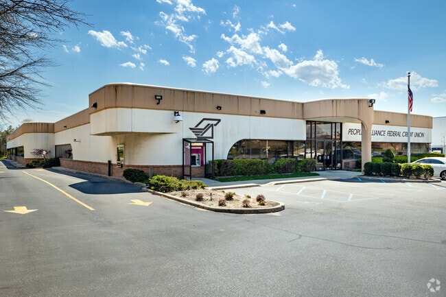
Property Record
125 Wireless Blvd, Hauppauge, NY 11788

NEARBY LISTINGS FOR SALE OR LEASE
Property Detail
125 Wireless Blvd
Nassau County-Suffolk County, NY
2-83651.60 TC-94 MACKAY IND PARK SEC 2 P/L 4 *7813
0800-181-00-01-00-001-082
Suffolk
Financialbuilding
New York
X
1
36103C0635H
3.06 AC
2024
Western Suffolk
2024
Long Island (New York)
145701
DEMOGRAPHICS near 125 Wireless Blvd
1 Mile
3 Mile
5 Mile
2024 Total Population
6,133
80,072
243,049
2029 Population
5,988
77,990
237,068
Pop Growth 2024-2029
(2.36%)
(2.60%)
(2.46%)
Average Age
38
39
40
2024 Total Households
1,524
21,538
69,758
HH Growth 2024-2029
(2.69%)
(2.75%)
(2.57%)
Median Household Inc
$146,914
$131,349
$126,081
Avg Household Size
3.60
3.40
3.20
2024 Avg HH Vehicles
3.00
2.00
2.00
Median Home Value
$469,437
$549,887
$513,201
Median Year Built
1964
1965
1966
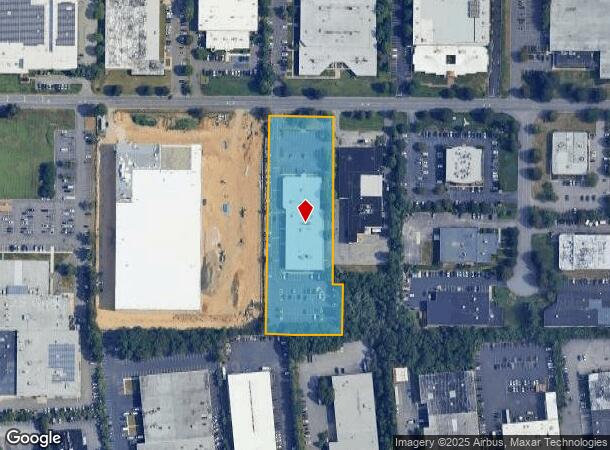
Nearby Places
Map Layers
Map Styles
 Street
 Aerial
- Restaurants
- Banks
- Shops
- Fitness
- Groceries
PUBLIC TRANSPORTATION
COMMUTER RAIL
Brentwood Station (Ronkonkoma Branch - Long Island Rail Road)
DRIVE
WALK
Distance
Brentwood Station (Ronkonkoma Branch - Long Island Rail Road)
10 min
4.0 mi
Central Islip Station (Ronkonkoma Branch - Long Island Rail Road)
DRIVE
WALK
Distance
Central Islip Station (Ronkonkoma Branch - Long Island Rail Road)
11 min
4.9 mi
AIRPORT
Long Island MacArthur
DRIVE
WALK
Distance
Long Island MacArthur
20 min
10.9 mi
LaGuardia
DRIVE
WALK
Distance
LaGuardia
55 min
36.7 mi
John F Kennedy International
DRIVE
WALK
Distance
John F Kennedy International
53 min
38.3 mi
Freight Ports
NY - Red Hook Container Terminal
DRIVE
WALK
Distance
NY - Red Hook Container Terminal
66 min
44.8 mi
SALE & LEASE HISTORY
LISTING DATE
SALE/LEASE

Sep 24, 2016
For Lease
Aug 01, 2017
For Lease
Apr 25, 2019
For Lease
Nearby Properties
Address
Land Use
TOTAL SIZE
Lot Size
Zoning
Address
Land Use
TOTAL SIZE
Lot Size
Zoning
301 SF
3.70 AC
Address
Land Use
TOTAL SIZE
Lot Size
Zoning
97.50 AC
AAA
Address
Land Use
TOTAL SIZE
Lot Size
Zoning
4.81 AC
AAA
Address
Land Use
TOTAL SIZE
Lot Size
Zoning
371.18 AC
AAA
Address
Land Use
TOTAL SIZE
Lot Size
Zoning
4.39 AC
AAA
Address
Land Use
TOTAL SIZE
Lot Size
Zoning
52.73 AC
AAA
Address
Land Use
TOTAL SIZE
Lot Size
Zoning
196.07 AC
AAA
Address
Land Use
TOTAL SIZE
Lot Size
Zoning
23.91 AC
IND1
Address
Land Use
TOTAL SIZE
Lot Size
Zoning
117.66 AC
AAA
Address
Land Use
TOTAL SIZE
Lot Size
Zoning
109.45 AC
AAA
Address
Land Use
TOTAL SIZE
Lot Size
Zoning
19.70 AC
A
Address
Land Use
TOTAL SIZE
Lot Size
Zoning
21.20 AC
AA
Address
Land Use
TOTAL SIZE
Lot Size
Zoning
30 AC
IND1
Address
Land Use
TOTAL SIZE
Lot Size
Zoning
30.50 AC
A
Address
Land Use
TOTAL SIZE
Lot Size
Zoning
18.37 AC
IND1
Address
Land Use
TOTAL SIZE
Lot Size
Zoning
10.20 AC
B
Address
Land Use
TOTAL SIZE
Lot Size
Zoning
14.08 AC
Address
Land Use
TOTAL SIZE
Lot Size
Zoning
10.90 AC
AAA
Address
Land Use
TOTAL SIZE
Lot Size
Zoning
20.13 AC
Address
Land Use
TOTAL SIZE
Lot Size
Zoning
4,624 SF
9.73 AC
A
Address
Land Use
TOTAL SIZE
Lot Size
Zoning
8.83 AC
Address
Land Use
TOTAL SIZE
Lot Size
Zoning
14.63 AC
IND1
Address
Land Use
TOTAL SIZE
Lot Size
Zoning
79.78 AC
AAA
Address
Land Use
TOTAL SIZE
Lot Size
Zoning
13.82 AC
BUS1
Address
Land Use
TOTAL SIZE
Lot Size
Zoning
52.32 AC
AAA
Address
Land Use
TOTAL SIZE
Lot Size
Zoning
3.98 AC
GSE
Address
Land Use
TOTAL SIZE
Lot Size
Zoning
13.28 AC
IND1
Address
Land Use
TOTAL SIZE
Lot Size
Zoning
12.20 AC
AA
Address
Land Use
TOTAL SIZE
Lot Size
Zoning
11.20 AC
A
Address
Land Use
TOTAL SIZE
Lot Size
Zoning
102.58 AC
AAA
The World's #1 Commercial Real Estate Marketplace
Connect with us
© 2026 CoStar Group
The information above has been obtained from sources believed reliable. While we do not doubt its accuracy we have not verified it and make no guarantee, warranty or representation about it. It is your responsibility to independently confirm its accuracy and completeness. Any projections, opinions, assumptions, or estimates used are for example only and do not represent the current or future performance of the property. The value of this transaction to you depends on tax and other factors which should be evaluated by your tax, financial, and legal advisors. You and your advisors should conduct a careful, independent investigation of the property to determine to your satisfaction the suitability of the property for your needs.