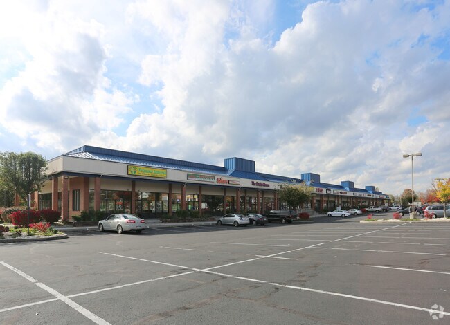
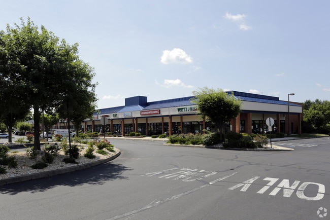
Property Record
1250 Bethlehem Pike, Hatfield, PA 19440

NEARBY LISTINGS FOR SALE OR LEASE
Property Detail
1250 Bethlehem Pike
35-00-00480-007
749 X IRR 6.9 AC
Commercialnec
Montgomery
X
Pennsylvania
42091C0142G
182
2024
11.19 AC
2025
West Montgomery County
200703
Philadelphia
42,494 SF
Philadelphia-Camden-Wilmington, PA-NJ-DE-MD
DEMOGRAPHICS near 1250 Bethlehem Pike
1 Mile
3 Mile
5 Mile
2024 Total Population
2,705
49,356
142,446
2029 Population
2,726
50,180
143,905
Pop Growth 2024-2029
+ 0.78%
+ 1.67%
+ 1.02%
Average Age
43
42
42
2024 Total Households
928
18,273
54,770
HH Growth 2024-2029
+ 0.65%
+ 1.60%
+ 0.97%
Median Household Inc
$143,840
$100,669
$100,992
Avg Household Size
2.90
2.60
2.50
2024 Avg HH Vehicles
2.00
2.00
2.00
Median Home Value
$393,173
$378,428
$367,221
Median Year Built
1976
1979
1979
Nearby Places
Map Layers
Map Styles
 Street
 Aerial
- Restaurants
- Banks
- Shops
- Fitness
- Groceries
PUBLIC TRANSPORTATION
AIRPORT
Lehigh Valley International
DRIVE
WALK
Distance
Lehigh Valley International
46 min
31.2 mi
Philadelphia International
DRIVE
WALK
Distance
Philadelphia International
55 min
43.6 mi
SALE & LEASE HISTORY
LISTING DATE
SALE/LEASE

Feb 11, 2019
For Lease
Nearby Properties
Address
Land Use
TOTAL SIZE
Lot Size
Zoning
Address
Land Use
TOTAL SIZE
Lot Size
Zoning
258,179 SF
65.34 AC
IN
Address
Land Use
TOTAL SIZE
Lot Size
Zoning
977,439 SF
70.93 AC
GA
Address
Land Use
TOTAL SIZE
Lot Size
Zoning
517,834 SF
31.33 AC
GA
Address
Land Use
TOTAL SIZE
Lot Size
Zoning
245,104 SF
31.21 AC
C
Address
Land Use
TOTAL SIZE
Lot Size
Zoning
253,915 SF
17.78 AC
GA
Address
Land Use
TOTAL SIZE
Lot Size
Zoning
767,474 SF
64.82 AC
RC
Address
Land Use
TOTAL SIZE
Lot Size
Zoning
334,450 SF
18.86 AC
GA
Address
Land Use
TOTAL SIZE
Lot Size
Zoning
131,631 SF
18.12 AC
SC
Address
Land Use
TOTAL SIZE
Lot Size
Zoning
289,681 SF
4.75 AC
BPO
Address
Land Use
TOTAL SIZE
Lot Size
Zoning
168,557 SF
44.77 AC
RA1
Address
Land Use
TOTAL SIZE
Lot Size
Zoning
444,718 SF
46.51 AC
LI
Address
Land Use
TOTAL SIZE
Lot Size
Zoning
324,796 SF
42.20 AC
LI
Address
Land Use
TOTAL SIZE
Lot Size
Zoning
502,169 SF
83.16 AC
LI
Address
Land Use
TOTAL SIZE
Lot Size
Zoning
35.37 AC
LI
Address
Land Use
TOTAL SIZE
Lot Size
Zoning
119,740 SF
9.80 AC
BP
Address
Land Use
TOTAL SIZE
Lot Size
Zoning
213,542 SF
26.53 AC
LI
Address
Land Use
TOTAL SIZE
Lot Size
Zoning
77,805 SF
21.18 AC
R2
Address
Land Use
TOTAL SIZE
Lot Size
Zoning
65,178 SF
16.86 AC
B
Address
Land Use
TOTAL SIZE
Lot Size
Zoning
198,551 SF
21.17 AC
LI
Address
Land Use
TOTAL SIZE
Lot Size
Zoning
134,272 SF
3.11 AC
S
Address
Land Use
TOTAL SIZE
Lot Size
Zoning
301,131 SF
18.98 AC
LI
Address
Land Use
TOTAL SIZE
Lot Size
Zoning
230,016 SF
11.27 AC
LI
Address
Land Use
TOTAL SIZE
Lot Size
Zoning
182,010 SF
12.25 AC
LI
Address
Land Use
TOTAL SIZE
Lot Size
Zoning
57,420 SF
2 AC
IN
Address
Land Use
TOTAL SIZE
Lot Size
Zoning
380,875 SF
40.10 AC
LI
Address
Land Use
TOTAL SIZE
Lot Size
Zoning
40,754 SF
6.23 AC
LI
Address
Land Use
TOTAL SIZE
Lot Size
Zoning
71,153 SF
20.48 AC
A1
Address
Land Use
TOTAL SIZE
Lot Size
Zoning
35,702 SF
1.75 AC
BPO
Address
Land Use
TOTAL SIZE
Lot Size
Zoning
60,470 SF
14.60 AC
ER
Address
Land Use
TOTAL SIZE
Lot Size
Zoning
85,508 SF
25.83 AC
The World's #1 Commercial Real Estate Marketplace
Connect with us
© 2025 CoStar Group
The information above has been obtained from sources believed reliable. While we do not doubt its accuracy we have not verified it and make no guarantee, warranty or representation about it. It is your responsibility to independently confirm its accuracy and completeness. Any projections, opinions, assumptions, or estimates used are for example only and do not represent the current or future performance of the property. The value of this transaction to you depends on tax and other factors which should be evaluated by your tax, financial, and legal advisors. You and your advisors should conduct a careful, independent investigation of the property to determine to your satisfaction the suitability of the property for your needs.