Property Record
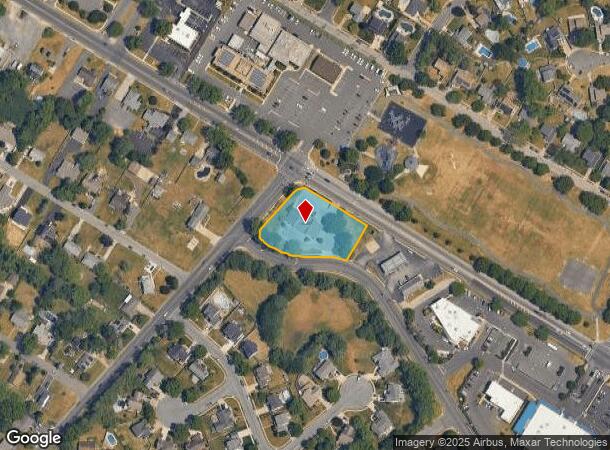
1250 Chews Land Clem Rd, Laurel Springs, NJ 08021

NEARBY LISTINGS FOR SALE OR LEASE
Property Detail
1250 Chews Land Clem Rd
Philadelphia-Camden-Wilmington, PA-NJ-DE-MD
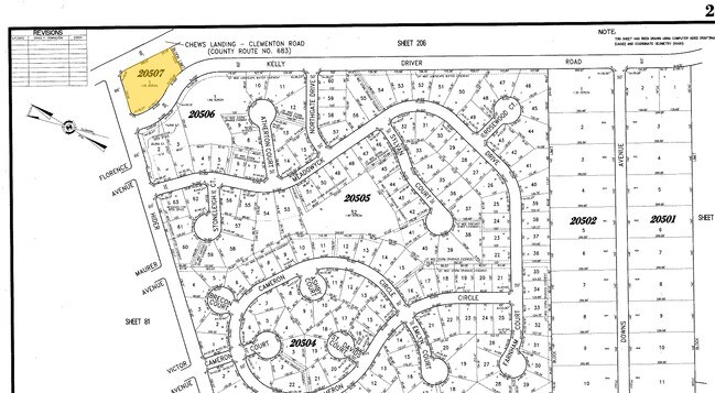
Minor Subdivision Plat Lot 1 Blk 20507 &
15-20507-0000-00001
Camden
Commercialnec
New Jersey
X
1
34007C0108E
0.91 AC
2024
South Camden County
2025
Philadelphia
608600
DEMOGRAPHICS near 1250 Chews Land Clem Rd
1 Mile
3 Mile
5 Mile
2024 Total Population
10,195
95,661
226,099
2029 Population
10,077
95,330
226,592
Pop Growth 2024-2029
(1.16%)
(0.35%)
+ 0.22%
Average Age
42
40
41
2024 Total Households
4,196
39,010
89,192
HH Growth 2024-2029
(1.07%)
(0.41%)
+ 0.16%
Median Household Inc
$93,278
$77,758
$85,709
Avg Household Size
2.40
2.40
2.50
2024 Avg HH Vehicles
2.00
2.00
2.00
Median Home Value
$243,802
$217,285
$244,331
Median Year Built
1975
1970
1971
Nearby Places
Map Layers
Map Styles
 Street
 Aerial
- Restaurants
- Banks
- Shops
- Fitness
- Groceries
PUBLIC TRANSPORTATION
COMMUTER RAIL
Lindenwold (Njt) (Atlantic City Line - NJ Transit Commuter Rail (NJ Transit))
DRIVE
WALK
Distance
Lindenwold (Njt) (Atlantic City Line - NJ Transit Commuter Rail (NJ Transit))
8 min
3.5 mi
Cherry Hill (Atlantic City Line - NJ Transit Commuter Rail (NJ Transit))
DRIVE
WALK
Distance
Cherry Hill (Atlantic City Line - NJ Transit Commuter Rail (NJ Transit))
18 min
9.8 mi
AIRPORT
Philadelphia International
DRIVE
WALK
Distance
Philadelphia International
32 min
18.1 mi
Freight Ports
Broadway Terminal - Pier 5
DRIVE
WALK
Distance
Broadway Terminal - Pier 5
17 min
9.6 mi
Nearby Properties
Address
Land Use
TOTAL SIZE
Lot Size
Zoning
Address
Land Use
TOTAL SIZE
Lot Size
Zoning
Address
Land Use
TOTAL SIZE
Lot Size
Zoning
54.91 AC
Address
Land Use
TOTAL SIZE
Lot Size
Zoning
Address
Land Use
TOTAL SIZE
Lot Size
Zoning
61.94 AC
R3
Address
Land Use
TOTAL SIZE
Lot Size
Zoning
46,360 SF
8.07 AC
Address
Land Use
TOTAL SIZE
Lot Size
Zoning
48 AC
R-3
Address
Land Use
TOTAL SIZE
Lot Size
Zoning
Address
Land Use
TOTAL SIZE
Lot Size
Zoning
49.56 AC
H
Address
Land Use
TOTAL SIZE
Lot Size
Zoning
33.50 AC
INS
Address
Land Use
TOTAL SIZE
Lot Size
Zoning
34.62 AC
Address
Land Use
TOTAL SIZE
Lot Size
Zoning
147,136 SF
9.55 AC
TC
Address
Land Use
TOTAL SIZE
Lot Size
Zoning
32.49 AC
Address
Land Use
TOTAL SIZE
Lot Size
Zoning
36.17 AC
Address
Land Use
TOTAL SIZE
Lot Size
Zoning
40,116 SF
2.84 AC
TC
Address
Land Use
TOTAL SIZE
Lot Size
Zoning
33.24 AC
INS
Address
Land Use
TOTAL SIZE
Lot Size
Zoning
Address
Land Use
TOTAL SIZE
Lot Size
Zoning
67.33 AC
BC2
Address
Land Use
TOTAL SIZE
Lot Size
Zoning
29.87 AC
R-3
Address
Land Use
TOTAL SIZE
Lot Size
Zoning
332,344 SF
11.99 AC
R10
Address
Land Use
TOTAL SIZE
Lot Size
Zoning
41.09 AC
Address
Land Use
TOTAL SIZE
Lot Size
Zoning
Address
Land Use
TOTAL SIZE
Lot Size
Zoning
28.93 AC
Address
Land Use
TOTAL SIZE
Lot Size
Zoning
3.50 AC
Address
Land Use
TOTAL SIZE
Lot Size
Zoning
5.29 AC
Address
Land Use
TOTAL SIZE
Lot Size
Zoning
17.27 AC
Address
Land Use
TOTAL SIZE
Lot Size
Zoning
Address
Land Use
TOTAL SIZE
Lot Size
Zoning
1,872 SF
180.40 AC
Address
Land Use
TOTAL SIZE
Lot Size
Zoning
80,816 SF
7.56 AC
TC
Address
Land Use
TOTAL SIZE
Lot Size
Zoning
30.37 AC
RA
Address
Land Use
TOTAL SIZE
Lot Size
Zoning
20.85 AC
R-3
The World's #1 Commercial Real Estate Marketplace
Connect with us
© 2025 CoStar Group
The information above has been obtained from sources believed reliable. While we do not doubt its accuracy we have not verified it and make no guarantee, warranty or representation about it. It is your responsibility to independently confirm its accuracy and completeness. Any projections, opinions, assumptions, or estimates used are for example only and do not represent the current or future performance of the property. The value of this transaction to you depends on tax and other factors which should be evaluated by your tax, financial, and legal advisors. You and your advisors should conduct a careful, independent investigation of the property to determine to your satisfaction the suitability of the property for your needs.