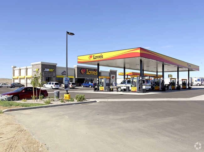
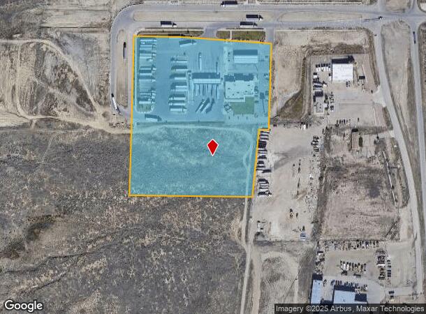
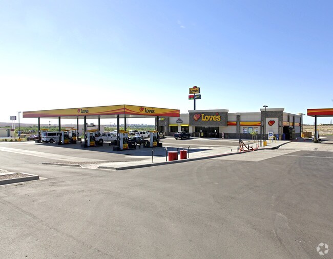
Property Record
1250 Drew Dix Pkwy, Pueblo, CO 81008
NEARBY LISTINGS FOR SALE OR LEASE
Property Detail
1250 Drew Dix Pkwy
Pueblo, CO
Com-Dillon Db
0-5-01-0-08-003
LOT 1 BLK 1 PINION RIDGE COMMERCIAL CENTER FILING NO 2,FORMERLY #05-010-00-065 + 05-010-08-001
Commercialacreage
Pueblo
X
Colorado
08101C0503D
1
2024
8.75 AC
2024
Colorado East Area
002919
Other Market Areas
19,653 SF
DEMOGRAPHICS near 1250 Drew Dix Pkwy
1 Mile
3 Mile
5 Mile
2024 Total Population
648
16,626
54,113
2029 Population
677
17,196
55,695
Pop Growth 2024-2029
+ 4.48%
+ 3.43%
+ 2.92%
Average Age
39
40
40
2024 Total Households
267
6,922
22,152
HH Growth 2024-2029
+ 4.49%
+ 3.64%
+ 3.06%
Median Household Inc
$57,940
$62,151
$55,317
Avg Household Size
2.40
2.30
2.30
2024 Avg HH Vehicles
2.00
2.00
2.00
Median Home Value
$301,389
$280,799
$251,678
Median Year Built
2006
1996
1976
Nearby Places
Map Layers
Map Styles
 Street
 Aerial
- Restaurants
- Banks
- Shops
- Fitness
- Groceries
Nearby Properties
Address
Land Use
TOTAL SIZE
Lot Size
Zoning
Address
Land Use
TOTAL SIZE
Lot Size
Zoning
61,095 SF
5.58 AC
B3:COMM/H&
Address
Land Use
TOTAL SIZE
Lot Size
Zoning
44,544 SF
4 AC
R5:RES/MUL
Address
Land Use
TOTAL SIZE
Lot Size
Zoning
200,121 SF
21.03 AC
B4:COMM/RE
Address
Land Use
TOTAL SIZE
Lot Size
Zoning
16,888 SF
5.31 AC
A-1
Address
Land Use
TOTAL SIZE
Lot Size
Zoning
15,741 SF
24.16 AC
R5:RES/MUL
Address
Land Use
TOTAL SIZE
Lot Size
Zoning
91,409 SF
12.23 AC
B-3
Address
Land Use
TOTAL SIZE
Lot Size
Zoning
50,464 SF
9.34 AC
B4:COMM/RE
Address
Land Use
TOTAL SIZE
Lot Size
Zoning
17,956 SF
3.31 AC
R1:RES/1 F
Address
Land Use
TOTAL SIZE
Lot Size
Zoning
25,180 SF
1.83 AC
B4:COMM/RE
Address
Land Use
TOTAL SIZE
Lot Size
Zoning
20,507 SF
2.93 AC
B3:COMM/H&
Address
Land Use
TOTAL SIZE
Lot Size
Zoning
202,847 SF
22.04 AC
B4:COMM/RE
Address
Land Use
TOTAL SIZE
Lot Size
Zoning
88,208 SF
11.96 AC
B-3
Address
Land Use
TOTAL SIZE
Lot Size
Zoning
104,405 SF
8.17 AC
A2:AG/1&2
Address
Land Use
TOTAL SIZE
Lot Size
Zoning
181,050 SF
12.97 AC
B3:COMM/H&
Address
Land Use
TOTAL SIZE
Lot Size
Zoning
146,292 SF
17.81 AC
B3:COMM/H&
Address
Land Use
TOTAL SIZE
Lot Size
Zoning
90,175 SF
7.86 AC
B3:COMM/H&
Address
Land Use
TOTAL SIZE
Lot Size
Zoning
26,467 SF
2.02 AC
B4:COMM/RE
Address
Land Use
TOTAL SIZE
Lot Size
Zoning
50,104 SF
6.56 AC
Address
Land Use
TOTAL SIZE
Lot Size
Zoning
81,322 SF
5.12 AC
B3:COMM/H&
Address
Land Use
TOTAL SIZE
Lot Size
Zoning
30,798 SF
2.53 AC
B4:COMM/RE
Address
Land Use
TOTAL SIZE
Lot Size
Zoning
51,748 SF
2.47 AC
B3:COMM/H&
Address
Land Use
TOTAL SIZE
Lot Size
Zoning
59,296 SF
1.58 AC
B3:COMM/H&
Address
Land Use
TOTAL SIZE
Lot Size
Zoning
55,207 SF
2.91 AC
B3:COMM/H&
Address
Land Use
TOTAL SIZE
Lot Size
Zoning
65,964 SF
2.44 AC
B3:COMM/H&
Address
Land Use
TOTAL SIZE
Lot Size
Zoning
138,008 SF
10.37 AC
B3:COMM/H&
Address
Land Use
TOTAL SIZE
Lot Size
Zoning
12,608 SF
2.50 AC
B2:COMM/SU
Address
Land Use
TOTAL SIZE
Lot Size
Zoning
40,100 SF
3.08 AC
B3:COMM/H&
Address
Land Use
TOTAL SIZE
Lot Size
Zoning
53,648 SF
1.99 AC
B-3
Address
Land Use
TOTAL SIZE
Lot Size
Zoning
124,364 SF
11.22 AC
B4:COMM/RE
Address
Land Use
TOTAL SIZE
Lot Size
Zoning
34,031 SF
2.85 AC
B3:COMM/H&
The World's #1 Commercial Real Estate Marketplace
Connect with us
© 2025 CoStar Group
The information above has been obtained from sources believed reliable. While we do not doubt its accuracy we have not verified it and make no guarantee, warranty or representation about it. It is your responsibility to independently confirm its accuracy and completeness. Any projections, opinions, assumptions, or estimates used are for example only and do not represent the current or future performance of the property. The value of this transaction to you depends on tax and other factors which should be evaluated by your tax, financial, and legal advisors. You and your advisors should conduct a careful, independent investigation of the property to determine to your satisfaction the suitability of the property for your needs.