Property Record
1250 E 200 S, Lehi, UT 84043
Current Lease Availabilities
NEARBY LISTINGS FOR SALE OR LEASE
Property Detail
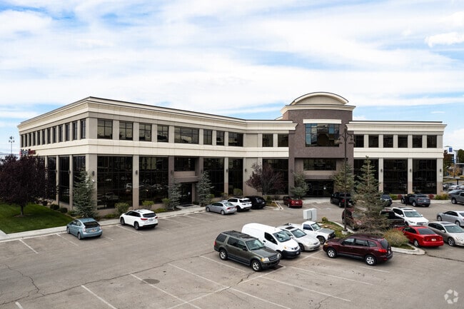
1250 E 200 S
Provo-Orem, UT
Discovery Offices Condos Phase 1
37-272-0019
UNIT 3E, DISCOVERY OFFICES CONDOS PHASE 1. AREA 0.053 AC.
Officebuilding
Utah
2024
Utah
2025
0.05 AC
000207
Utah County
2,720 SF
Salt Lake City
DEMOGRAPHICS near 1250 E 200 S
1 Mile
3 Mile
5 Mile
2024 Total Population
7,805
80,956
185,452
2029 Population
9,129
94,595
217,932
Pop Growth 2024-2029
+ 16.96%
+ 16.85%
+ 17.51%
Average Age
33
32
31
2024 Total Households
2,261
22,062
51,599
HH Growth 2024-2029
+ 17.38%
+ 17.25%
+ 17.95%
Median Household Inc
$83,682
$104,134
$109,222
Avg Household Size
3.30
3.60
3.60
2024 Avg HH Vehicles
2.00
3.00
2.00
Median Home Value
$489,053
$496,870
$505,758
Median Year Built
1997
2000
2006
Nearby Places
Map Layers
Map Styles
 Street
 Aerial
- Restaurants
- Banks
- Shops
- Fitness
- Groceries
PUBLIC TRANSPORTATION
COMMUTER RAIL
DRIVE
WALK
Distance
6 min
2.4 mi
DRIVE
WALK
Distance
10 min
5.7 mi
AIRPORT
Provo Municipal
DRIVE
WALK
Distance
Provo Municipal
23 min
17.5 mi
Salt Lake City International
DRIVE
WALK
Distance
Salt Lake City International
40 min
33.7 mi
Nearby Properties
Address
Land Use
TOTAL SIZE
Lot Size
Zoning
Address
Land Use
TOTAL SIZE
Lot Size
Zoning
359,445 SF
6.46 AC
Address
Land Use
TOTAL SIZE
Lot Size
Zoning
305,553 SF
13.08 AC
Address
Land Use
TOTAL SIZE
Lot Size
Zoning
181,908 SF
1.43 AC
Address
Land Use
TOTAL SIZE
Lot Size
Zoning
227,030 SF
21.91 AC
Address
Land Use
TOTAL SIZE
Lot Size
Zoning
201,838 SF
8.83 AC
Address
Land Use
TOTAL SIZE
Lot Size
Zoning
182,338 SF
7.97 AC
Address
Land Use
TOTAL SIZE
Lot Size
Zoning
153,790 SF
12.07 AC
Address
Land Use
TOTAL SIZE
Lot Size
Zoning
200,016 SF
8.82 AC
Address
Land Use
TOTAL SIZE
Lot Size
Zoning
122,777 SF
6.68 AC
Address
Land Use
TOTAL SIZE
Lot Size
Zoning
149,937 SF
13.49 AC
Address
Land Use
TOTAL SIZE
Lot Size
Zoning
143,438 SF
7.43 AC
Address
Land Use
TOTAL SIZE
Lot Size
Zoning
100,814 SF
8.22 AC
Address
Land Use
TOTAL SIZE
Lot Size
Zoning
62,104 SF
8.97 AC
Address
Land Use
TOTAL SIZE
Lot Size
Zoning
110,561 SF
6.47 AC
Address
Land Use
TOTAL SIZE
Lot Size
Zoning
1,121 SF
4.07 AC
Address
Land Use
TOTAL SIZE
Lot Size
Zoning
137,193 SF
12.45 AC
Address
Land Use
TOTAL SIZE
Lot Size
Zoning
111,292 SF
5.36 AC
Address
Land Use
TOTAL SIZE
Lot Size
Zoning
100,973 SF
5.71 AC
Address
Land Use
TOTAL SIZE
Lot Size
Zoning
76,420 SF
3.94 AC
Address
Land Use
TOTAL SIZE
Lot Size
Zoning
91,812 SF
6.99 AC
Address
Land Use
TOTAL SIZE
Lot Size
Zoning
124,836 SF
8.74 AC
Address
Land Use
TOTAL SIZE
Lot Size
Zoning
114,574 SF
6.78 AC
Address
Land Use
TOTAL SIZE
Lot Size
Zoning
65,449 SF
2.27 AC
Address
Land Use
TOTAL SIZE
Lot Size
Zoning
157,950 SF
6.53 AC
Address
Land Use
TOTAL SIZE
Lot Size
Zoning
107,722 SF
5.65 AC
Address
Land Use
TOTAL SIZE
Lot Size
Zoning
105,188 SF
10.64 AC
Address
Land Use
TOTAL SIZE
Lot Size
Zoning
97,088 SF
3.88 AC
Address
Land Use
TOTAL SIZE
Lot Size
Zoning
95,683 SF
9.32 AC
Address
Land Use
TOTAL SIZE
Lot Size
Zoning
58,277 SF
7.49 AC
Address
Land Use
TOTAL SIZE
Lot Size
Zoning
51,230 SF
5.19 AC
The World's #1 Commercial Real Estate Marketplace
Connect with us
© 2026 CoStar Group
The information above has been obtained from sources believed reliable. While we do not doubt its accuracy we have not verified it and make no guarantee, warranty or representation about it. It is your responsibility to independently confirm its accuracy and completeness. Any projections, opinions, assumptions, or estimates used are for example only and do not represent the current or future performance of the property. The value of this transaction to you depends on tax and other factors which should be evaluated by your tax, financial, and legal advisors. You and your advisors should conduct a careful, independent investigation of the property to determine to your satisfaction the suitability of the property for your needs.