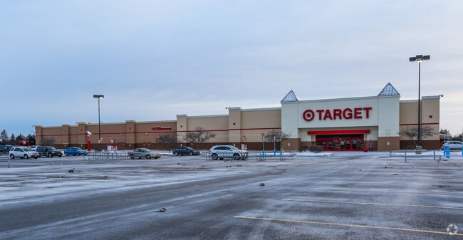
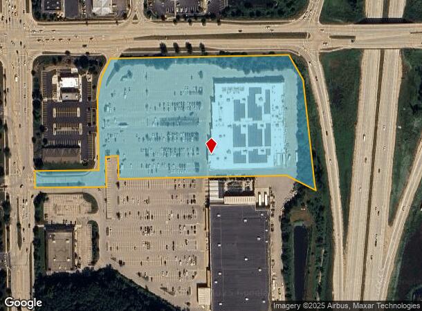
Property Record
1250 N Port Washington Rd, Grafton, WI 53024

NEARBY LISTINGS FOR SALE OR LEASE
Property Detail
1250 N Port Washington Rd
Milwaukee/Madison
1171/877 1129/989 PART SW NW COMM 60 FT E & 764 FT N OF SW COR BEING #3088 CSM LOT 3 DOC 0614395 *EXC I-43 - 1124210* SEC 20 T 10 R 22 (SEE 10-020-07-007.00 - 1794/460
Milwaukee-Waukesha, WI
Ozaukee
100200701100
Wisconsin
Commercialnec
3
2024
10.11 AC
2024
North Ozaukee
640202
DEMOGRAPHICS near 1250 N Port Washington Rd
1 Mile
3 Mile
5 Mile
2024 Total Population
2,663
19,384
44,389
2029 Population
2,819
20,281
46,156
Pop Growth 2024-2029
+ 5.86%
+ 4.63%
+ 3.98%
Average Age
43
43
42
2024 Total Households
1,100
8,244
18,027
HH Growth 2024-2029
+ 5.91%
+ 4.55%
+ 3.91%
Median Household Inc
$106,408
$82,222
$78,357
Avg Household Size
2.40
2.30
2.30
2024 Avg HH Vehicles
2.00
2.00
2.00
Median Home Value
$341,287
$305,906
$320,467
Median Year Built
1995
1980
1977
Nearby Places
Map Layers
Map Styles
 Street
 Aerial
- Restaurants
- Banks
- Shops
- Fitness
- Groceries
PUBLIC TRANSPORTATION
AIRPORT
General Mitchell International
DRIVE
WALK
Distance
General Mitchell International
39 min
27.4 mi
Freight Ports
Port Milwaukee
DRIVE
WALK
Distance
Port Milwaukee
32 min
23.2 mi
Nearby Properties
Address
Land Use
TOTAL SIZE
Lot Size
Zoning
Address
Land Use
TOTAL SIZE
Lot Size
Zoning
14.07 AC
Address
Land Use
TOTAL SIZE
Lot Size
Zoning
Address
Land Use
TOTAL SIZE
Lot Size
Zoning
23.51 AC
Address
Land Use
TOTAL SIZE
Lot Size
Zoning
21.24 AC
Address
Land Use
TOTAL SIZE
Lot Size
Zoning
Address
Land Use
TOTAL SIZE
Lot Size
Zoning
7.64 AC
Address
Land Use
TOTAL SIZE
Lot Size
Zoning
65.65 AC
Address
Land Use
TOTAL SIZE
Lot Size
Zoning
27.63 AC
Address
Land Use
TOTAL SIZE
Lot Size
Zoning
Address
Land Use
TOTAL SIZE
Lot Size
Zoning
Address
Land Use
TOTAL SIZE
Lot Size
Zoning
9.01 AC
Address
Land Use
TOTAL SIZE
Lot Size
Zoning
Address
Land Use
TOTAL SIZE
Lot Size
Zoning
27.88 AC
Address
Land Use
TOTAL SIZE
Lot Size
Zoning
3.02 AC
Address
Land Use
TOTAL SIZE
Lot Size
Zoning
8.34 AC
Address
Land Use
TOTAL SIZE
Lot Size
Zoning
9.80 AC
Address
Land Use
TOTAL SIZE
Lot Size
Zoning
9.30 AC
Address
Land Use
TOTAL SIZE
Lot Size
Zoning
18.54 AC
Address
Land Use
TOTAL SIZE
Lot Size
Zoning
9.83 AC
Address
Land Use
TOTAL SIZE
Lot Size
Zoning
2.03 AC
Address
Land Use
TOTAL SIZE
Lot Size
Zoning
10.26 AC
Address
Land Use
TOTAL SIZE
Lot Size
Zoning
3.44 AC
Address
Land Use
TOTAL SIZE
Lot Size
Zoning
5.83 AC
Address
Land Use
TOTAL SIZE
Lot Size
Zoning
6.69 AC
Address
Land Use
TOTAL SIZE
Lot Size
Zoning
24.48 AC
Address
Land Use
TOTAL SIZE
Lot Size
Zoning
9.57 AC
Address
Land Use
TOTAL SIZE
Lot Size
Zoning
5.61 AC
Address
Land Use
TOTAL SIZE
Lot Size
Zoning
0.92 AC
Address
Land Use
TOTAL SIZE
Lot Size
Zoning
6.07 AC
The World's #1 Commercial Real Estate Marketplace
Connect with us
© 2026 CoStar Group
The information above has been obtained from sources believed reliable. While we do not doubt its accuracy we have not verified it and make no guarantee, warranty or representation about it. It is your responsibility to independently confirm its accuracy and completeness. Any projections, opinions, assumptions, or estimates used are for example only and do not represent the current or future performance of the property. The value of this transaction to you depends on tax and other factors which should be evaluated by your tax, financial, and legal advisors. You and your advisors should conduct a careful, independent investigation of the property to determine to your satisfaction the suitability of the property for your needs.