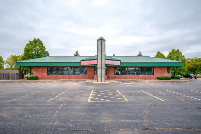
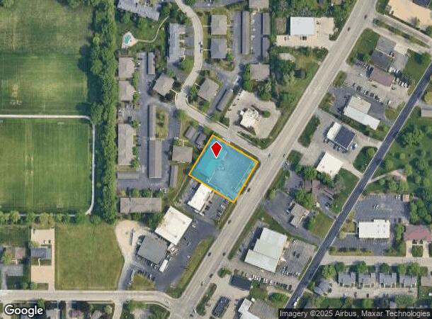
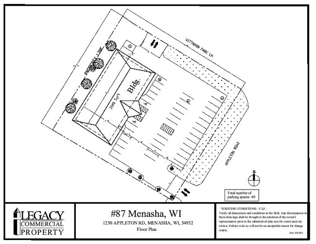
Property Record
1250 Appleton Rd, Menasha, WI 54952
Current Lease Availabilities
NEARBY LISTINGS FOR SALE OR LEASE
Property Detail
1250 Appleton Rd
Oshkosh-Neenah, WI
Certified Survey Map No 3448
4-00922-01
LOT 2 OF CSM #3448 REC AS DOC #940851 WINNEBAGO CO R.O.D.
Commercialnec
Winnebago
X
Wisconsin
55087C0431D
2
2024
0.89 AC
2024
Appleton/Oshkosh
002601
Other Market Areas
7,030 SF
DEMOGRAPHICS near 1250 Appleton Rd
1 Mile
3 Mile
5 Mile
2024 Total Population
9,144
65,161
154,511
2029 Population
9,131
66,478
157,780
Pop Growth 2024-2029
(0.14%)
+ 2.02%
+ 2.12%
Average Age
41
39
40
2024 Total Households
4,017
27,608
64,844
HH Growth 2024-2029
(0.27%)
+ 1.91%
+ 2.07%
Median Household Inc
$55,231
$60,543
$66,298
Avg Household Size
2.20
2.30
2.30
2024 Avg HH Vehicles
2.00
2.00
2.00
Median Home Value
$160,883
$174,976
$183,301
Median Year Built
1975
1974
1973
Nearby Places
Map Layers
Map Styles
 Street
 Aerial
- Restaurants
- Banks
- Shops
- Fitness
- Groceries
PUBLIC TRANSPORTATION
AIRPORT
Appleton International
DRIVE
WALK
Distance
Appleton International
14 min
8.5 mi
Green Bay/Austin Straubel International
DRIVE
WALK
Distance
Green Bay/Austin Straubel International
39 min
30.4 mi
Freight Ports
Port Milwaukee
DRIVE
WALK
Distance
Port Milwaukee
124 min
107.0 mi
Nearby Properties
Address
Land Use
TOTAL SIZE
Lot Size
Zoning
Address
Land Use
TOTAL SIZE
Lot Size
Zoning
8.61 AC
R5
Address
Land Use
TOTAL SIZE
Lot Size
Zoning
17.51 AC
Address
Land Use
TOTAL SIZE
Lot Size
Zoning
11,340 SF
0.92 AC
C2
Address
Land Use
TOTAL SIZE
Lot Size
Zoning
29,742 SF
5.95 AC
R3
Address
Land Use
TOTAL SIZE
Lot Size
Zoning
267,069 SF
26.76 AC
Address
Land Use
TOTAL SIZE
Lot Size
Zoning
89,042 SF
2.83 AC
C2
Address
Land Use
TOTAL SIZE
Lot Size
Zoning
53,321 SF
2.51 AC
CBD
Address
Land Use
TOTAL SIZE
Lot Size
Zoning
209,059 SF
18.40 AC
PDC2
Address
Land Use
TOTAL SIZE
Lot Size
Zoning
44,164 SF
0.62 AC
CBD
Address
Land Use
TOTAL SIZE
Lot Size
Zoning
25.62 AC
I2
Address
Land Use
TOTAL SIZE
Lot Size
Zoning
20.92 AC
R5
Address
Land Use
TOTAL SIZE
Lot Size
Zoning
108,328 SF
8.93 AC
R3
Address
Land Use
TOTAL SIZE
Lot Size
Zoning
20,874 SF
11.57 AC
R4
Address
Land Use
TOTAL SIZE
Lot Size
Zoning
67,817 SF
21.36 AC
C2
Address
Land Use
TOTAL SIZE
Lot Size
Zoning
5,394 SF
0.30 AC
CBD
Address
Land Use
TOTAL SIZE
Lot Size
Zoning
21,540 SF
0.79 AC
CBD
Address
Land Use
TOTAL SIZE
Lot Size
Zoning
92,296 SF
13.33 AC
R1
Address
Land Use
TOTAL SIZE
Lot Size
Zoning
78,268 SF
7.80 AC
C3
Address
Land Use
TOTAL SIZE
Lot Size
Zoning
1.91 AC
B5
Address
Land Use
TOTAL SIZE
Lot Size
Zoning
18.18 AC
I1
Address
Land Use
TOTAL SIZE
Lot Size
Zoning
97,867 SF
14.72 AC
R3
Address
Land Use
TOTAL SIZE
Lot Size
Zoning
248,212 SF
7.87 AC
M2
Address
Land Use
TOTAL SIZE
Lot Size
Zoning
6,000 SF
1.70 AC
CBD
Address
Land Use
TOTAL SIZE
Lot Size
Zoning
70,473 SF
10.07 AC
C2
Address
Land Use
TOTAL SIZE
Lot Size
Zoning
16,486 SF
10.06 AC
PDR3
Address
Land Use
TOTAL SIZE
Lot Size
Zoning
12.02 AC
M2
Address
Land Use
TOTAL SIZE
Lot Size
Zoning
81,440 SF
6.70 AC
C1
Address
Land Use
TOTAL SIZE
Lot Size
Zoning
13,644 SF
0.39 AC
CBD
Address
Land Use
TOTAL SIZE
Lot Size
Zoning
270,489 SF
18.25 AC
M2
Address
Land Use
TOTAL SIZE
Lot Size
Zoning
43.70 AC
The World's #1 Commercial Real Estate Marketplace
Connect with us
© 2026 CoStar Group
The information above has been obtained from sources believed reliable. While we do not doubt its accuracy we have not verified it and make no guarantee, warranty or representation about it. It is your responsibility to independently confirm its accuracy and completeness. Any projections, opinions, assumptions, or estimates used are for example only and do not represent the current or future performance of the property. The value of this transaction to you depends on tax and other factors which should be evaluated by your tax, financial, and legal advisors. You and your advisors should conduct a careful, independent investigation of the property to determine to your satisfaction the suitability of the property for your needs.