Property Record
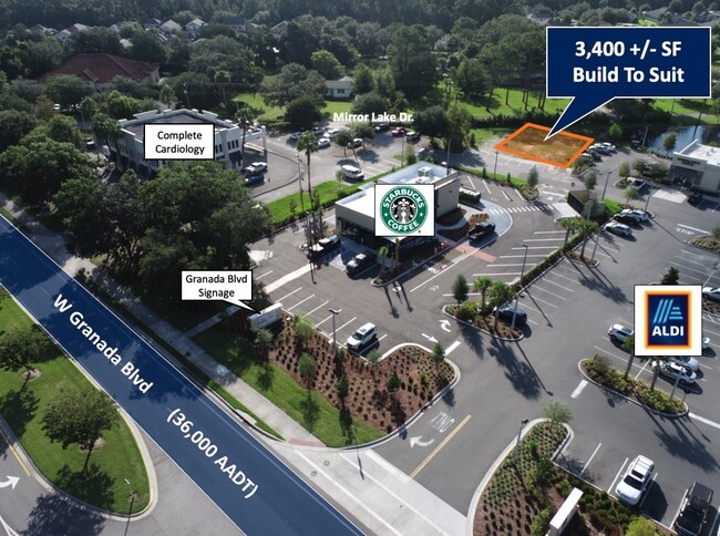
1250 W Granada Blvd, Ormond Beach, FL 32174


Property Detail
1250 W Granada Blvd
Deltona-Daytona Beach-Ormond Beach, FL
30-14-32 UNIT 4 GRANADA II ORMOND COMMERCIAL CONDO PER OR 7587 PG 1241 PER OR 7587 PGS 4394-4396 INC PER OR 8319 PG 3421
4230-20-00-0040
Volusia
Commercialacreage
Florida
A Areas with a 1% annual chance of flooding and a 26% chance of flooding over the life of a 30-year mortgage.
0.08 AC
2025
Ormond Beach
2026
Deltona/Daytona Beach
080808
NEARBY LISTINGS FOR SALE OR LEASE
DEMOGRAPHICS near 1250 W Granada Blvd
1 mile
3 mile
5 mile
2025 Total Population
6,639
44,970
108,588
2030 Population
7,258
48,415
117,849
Pop Growth 2025-2030
+ 9.32%
+ 7.66%
+ 8.53%
Average Age
50
46
46
2025 Total Households
2,976
19,460
47,911
HH Growth 2025-2030
+ 9.41%
+ 7.73%
+ 8.63%
Median Household Inc
$62,143
$59,552
$59,778
Avg Household Size
2.10
2.20
2.20
2025 Avg HH Vehicles
2.00
2.00
2.00
Median Home Value
$360,408
$334,222
$347,971
Median Year Built
1991
1988
1983
Nearby Places
Map Layers
Map Styles
 Street
 Aerial
Transit
 Traffic
 Biking
Places
Listings with unknown addresses are not visible on the map
- Restaurants
- Banks
- Shops
- Fitness
- Groceries
PUBLIC TRANSPORTATION
AIRPORT
Daytona Beach International
Drive
Walk
Distance
Daytona Beach International
17 min
10.1 mi
Freight Ports
Port Canaveral
Drive
Walk
Distance
Port Canaveral
90 min
77.3 mi
SALE & LEASE HISTORY
LISTING DATE
SALE/LEASE

Oct 25, 2022
For Lease
Feb 19, 2019
For Sale
Nearby Properties
Address
Land Use
TOTAL SIZE
Lot Size
Zoning
Address
Land Use
TOTAL SIZE
Lot Size
Zoning
849,735 SF
140.62 AC
01A2
Address
Land Use
TOTAL SIZE
Lot Size
Zoning
437,897 SF
28.94 AC
Address
Land Use
TOTAL SIZE
Lot Size
Zoning
451,526 SF
17.96 AC
Address
Land Use
TOTAL SIZE
Lot Size
Zoning
293,850 SF
29.38 AC
Address
Land Use
TOTAL SIZE
Lot Size
Zoning
491,161 SF
31 AC
Address
Land Use
TOTAL SIZE
Lot Size
Zoning
12,394 SF
139.59 AC
Address
Land Use
TOTAL SIZE
Lot Size
Zoning
135,122 SF
78 AC
Address
Land Use
TOTAL SIZE
Lot Size
Zoning
470,843 SF
1.78 AC
RC
Address
Land Use
TOTAL SIZE
Lot Size
Zoning
10,637 SF
0.15 AC
R2
Address
Land Use
TOTAL SIZE
Lot Size
Zoning
307,322 SF
65.41 AC
Address
Land Use
TOTAL SIZE
Lot Size
Zoning
409,718 SF
12.86 AC
Address
Land Use
TOTAL SIZE
Lot Size
Zoning
434,487 SF
20.54 AC
Address
Land Use
TOTAL SIZE
Lot Size
Zoning
425,548 SF
10.16 AC
Address
Land Use
TOTAL SIZE
Lot Size
Zoning
375,572 SF
0.13 AC
R2
Address
Land Use
TOTAL SIZE
Lot Size
Zoning
359,180 SF
29.73 AC
01A2
Address
Land Use
TOTAL SIZE
Lot Size
Zoning
333,708 SF
0.24 AC
01A2
Address
Land Use
TOTAL SIZE
Lot Size
Zoning
346,734 SF
14 AC
Address
Land Use
TOTAL SIZE
Lot Size
Zoning
158,299 SF
22 AC
Address
Land Use
TOTAL SIZE
Lot Size
Zoning
180,767 SF
27.05 AC
13R6
Address
Land Use
TOTAL SIZE
Lot Size
Zoning
60,873 SF
8.82 AC
Address
Land Use
TOTAL SIZE
Lot Size
Zoning
184,301 SF
50.28 AC
Address
Land Use
TOTAL SIZE
Lot Size
Zoning
184,829 SF
9.71 AC
01A2
Address
Land Use
TOTAL SIZE
Lot Size
Zoning
56,220 SF
13.13 AC
Address
Land Use
TOTAL SIZE
Lot Size
Zoning
168,456 SF
15.74 AC
Address
Land Use
TOTAL SIZE
Lot Size
Zoning
4,182 SF
0.16 AC
MH1
Address
Land Use
TOTAL SIZE
Lot Size
Zoning
Address
Land Use
TOTAL SIZE
Lot Size
Zoning
144,576 SF
11.19 AC
13R6
Address
Land Use
TOTAL SIZE
Lot Size
Zoning
107,478 SF
11.73 AC
Address
Land Use
TOTAL SIZE
Lot Size
Zoning
162,450 SF
1.42 AC
13B9
Address
Land Use
TOTAL SIZE
Lot Size
Zoning
46,751 SF
37.07 AC
The World's #1 Commercial Real Estate Marketplace
Connect with us
© 2026 CoStar Group
The information above has been obtained from sources believed reliable. While we do not doubt its accuracy we have not verified it and make no guarantee, warranty or representation about it. It is your responsibility to independently confirm its accuracy and completeness. Any projections, opinions, assumptions, or estimates used are for example only and do not represent the current or future performance of the property. The value of this transaction to you depends on tax and other factors which should be evaluated by your tax, financial, and legal advisors. You and your advisors should conduct a careful, independent investigation of the property to determine to your satisfaction the suitability of the property for your needs.