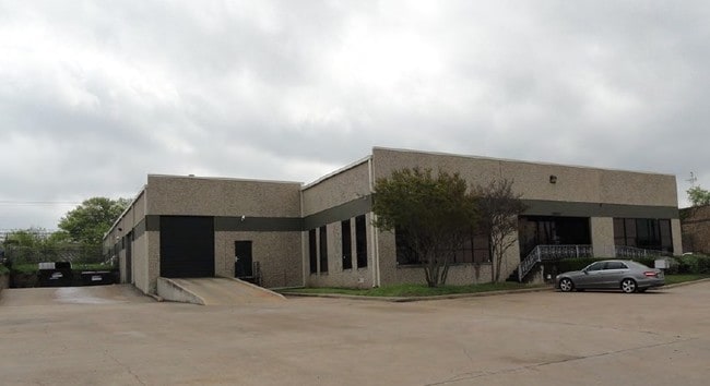
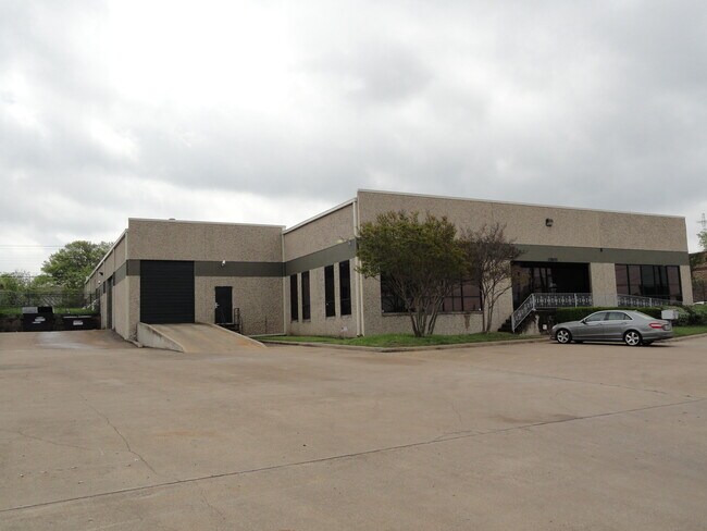
Property Record
12500 Schroeder Rd, Dallas, TX 75243

Property Detail
12500 Schroeder Rd
00000757510000000
A A THOMAS SUR A-1486 1.045 AC E SIDE SCHROEDER INT201300334044 DD10242013 CO-DC 7622 000 00200 3007622 000
Warehouse
DALLAS
Z151
Texas
B and X Area of moderate flood hazard, usually the area between the limits of the 100-year and 500-year floods.
2
2024
1.05 AC
2025
NE Dallas/Garland
007829
Dallas/Ft Worth
18,160 SF
Dallas-Fort Worth-Arlington, TX
NEARBY LISTINGS FOR SALE OR LEASE
DEMOGRAPHICS near 12500 Schroeder Rd
1 mile
3 mile
5 mile
2025 Total Population
19,889
159,237
417,063
2030 Population
20,653
164,201
430,713
Pop Growth 2025-2030
+ 3.84%
+ 3.12%
+ 3.27%
Average Age
35
37
38
2025 Total Households
9,190
67,261
177,037
HH Growth 2025-2030
+ 3.95%
+ 3.19%
+ 3.40%
Median Household Inc
$63,337
$70,039
$77,094
Avg Household Size
2.10
2.30
2.30
2025 Avg HH Vehicles
1.00
2.00
2.00
Median Home Value
$231,986
$529,630
$539,868
Median Year Built
1988
1979
1979
Nearby Places
Map Layers
Map Styles
 Street
 Aerial
Layers
 Traffic
 Biking
Places
Listings with unknown addresses are not visible on the map
- Restaurants
- Banks
- Shops
- Fitness
- Groceries
PUBLIC TRANSPORTATION
TRANSIT/SUBWAY
Lbj/Central (Orange Line - Dallas Area Rapid Transit (DART), Red Line - Dallas Area Rapid Transit (DART))
Drive
Walk
Distance
Lbj/Central (Orange Line - Dallas Area Rapid Transit (DART), Red Line - Dallas Area Rapid Transit (DART))
2 min
13 min
0.7 mi
Forest Ln Station (DART LIGHT RAIL - ORANGE LINE - Dallas Area Rapid Transit (DART), DART LIGHT RAIL - RED LINE - Dallas Area Rapid Transit (DART))
Drive
Walk
Distance
Forest Ln Station (DART LIGHT RAIL - ORANGE LINE - Dallas Area Rapid Transit (DART), DART LIGHT RAIL - RED LINE - Dallas Area Rapid Transit (DART))
3 min
16 min
0.9 mi
AIRPORT
Dallas Love Field
Drive
Walk
Distance
Dallas Love Field
20 min
10.9 mi
Dallas-Fort Worth International
Drive
Walk
Distance
Dallas-Fort Worth International
29 min
22.4 mi
Freight Ports
Port of Shreveport
Drive
Walk
Distance
Port of Shreveport
215 min
198.9 mi
SALE & LEASE HISTORY
LISTING DATE
SALE/LEASE

May 21, 2021
For Lease
Nearby Properties
Address
Land Use
TOTAL SIZE
Lot Size
Zoning
Address
Land Use
TOTAL SIZE
Lot Size
Zoning
7,706,477 SF
245.55 AC
Z116
Address
Land Use
TOTAL SIZE
Lot Size
Zoning
2,186,362 SF
48.27 AC
Z239
Address
Land Use
TOTAL SIZE
Lot Size
Zoning
1,252,860 SF
57.08 AC
Z239
Address
Land Use
TOTAL SIZE
Lot Size
Zoning
3,423,779 SF
32.42 AC
Z151
Address
Land Use
TOTAL SIZE
Lot Size
Zoning
1,086,919 SF
5.85 AC
Z239
Address
Land Use
TOTAL SIZE
Lot Size
Zoning
557,392 SF
10.06 AC
Z239
Address
Land Use
TOTAL SIZE
Lot Size
Zoning
835,301 SF
9.29 AC
Z239
Address
Land Use
TOTAL SIZE
Lot Size
Zoning
421,798 SF
9 AC
Z151
Address
Land Use
TOTAL SIZE
Lot Size
Zoning
852,562 SF
13.86 AC
Z151
Address
Land Use
TOTAL SIZE
Lot Size
Zoning
706,061 SF
36.76 AC
Z109
Address
Land Use
TOTAL SIZE
Lot Size
Zoning
428,956 SF
18.76 AC
Z291
Address
Land Use
TOTAL SIZE
Lot Size
Zoning
485,067 SF
14.87 AC
Z239
Address
Land Use
TOTAL SIZE
Lot Size
Zoning
462,916 SF
15.67 AC
Z248
Address
Land Use
TOTAL SIZE
Lot Size
Zoning
249,692 SF
244.62 AC
Z239
Address
Land Use
TOTAL SIZE
Lot Size
Zoning
595,526 SF
6.92 AC
Z151
Address
Land Use
TOTAL SIZE
Lot Size
Zoning
379,592 SF
12.75 AC
Z248
Address
Land Use
TOTAL SIZE
Lot Size
Zoning
592,314 SF
4.19 AC
Z96
Address
Land Use
TOTAL SIZE
Lot Size
Zoning
456,300 SF
10.92 AC
Z239
Address
Land Use
TOTAL SIZE
Lot Size
Zoning
999,432 SF
5.78 AC
Z96
Address
Land Use
TOTAL SIZE
Lot Size
Zoning
424,666 SF
12.19 AC
Z151
Address
Land Use
TOTAL SIZE
Lot Size
Zoning
316,085 SF
13.73 AC
Z107
Address
Land Use
TOTAL SIZE
Lot Size
Zoning
347,933 SF
12.61 AC
Z164
Address
Land Use
TOTAL SIZE
Lot Size
Zoning
278,210 SF
6.84 AC
Z248
Address
Land Use
TOTAL SIZE
Lot Size
Zoning
479,179 SF
5 AC
Z151
Address
Land Use
TOTAL SIZE
Lot Size
Zoning
593,252 SF
8.50 AC
Z164
Address
Land Use
TOTAL SIZE
Lot Size
Zoning
1,099,201 SF
107.82 AC
Z116
Address
Land Use
TOTAL SIZE
Lot Size
Zoning
381,882 SF
18.89 AC
Z163
Address
Land Use
TOTAL SIZE
Lot Size
Zoning
223,664 SF
19.22 AC
Address
Land Use
TOTAL SIZE
Lot Size
Zoning
460,773 SF
4.51 AC
Z239
Address
Land Use
TOTAL SIZE
Lot Size
Zoning
439,215 SF
3.89 AC
Z151
The World's #1 Commercial Real Estate Marketplace
Connect with us
© 2026 CoStar Group
The information above has been obtained from sources believed reliable. While we do not doubt its accuracy we have not verified it and make no guarantee, warranty or representation about it. It is your responsibility to independently confirm its accuracy and completeness. Any projections, opinions, assumptions, or estimates used are for example only and do not represent the current or future performance of the property. The value of this transaction to you depends on tax and other factors which should be evaluated by your tax, financial, and legal advisors. You and your advisors should conduct a careful, independent investigation of the property to determine to your satisfaction the suitability of the property for your needs.