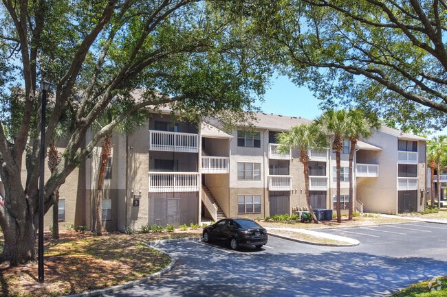
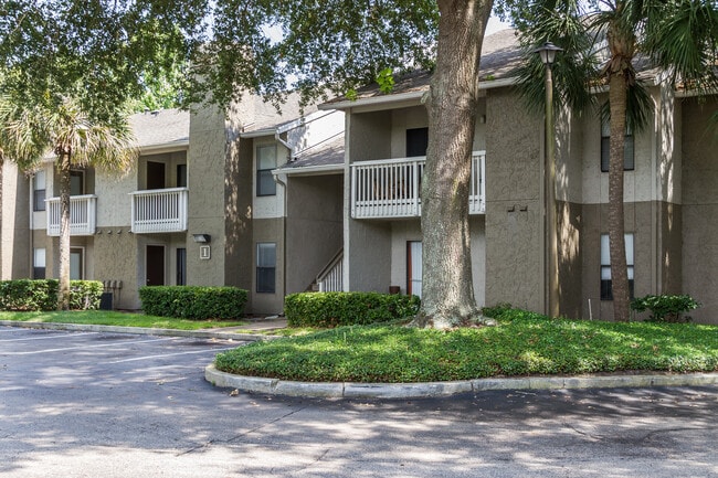
Property Record
1251 Beacon Point Dr, Jacksonville, FL 32246


Save to a Folder
{{folder.Name}}
{{folder.ListingIds.length}} Properties
{{folder.ListingIds.length}} Property
Create a New Folder
Property Detail
1251 Beacon Point Dr
123022-0100
24-2S-27E 12.01 PT N1/2 RECD O/R 20126-1429, 20-57 SOUTHSIDE ESTATES UNIT 3 LOTS 1,2,3 BLK 28A
Apartmenthouse5plusunits
Duval
RMD-D
Florida
B and X Area of moderate flood hazard, usually the area between the limits of the 100-year and 500-year floods.
1,2,3
2025
11.77 AC
2026
Southside Estates
014500
Jacksonville (Florida)
116,814 SF
Jacksonville, FL
NEARBY LISTINGS FOR SALE OR LEASE
-
-
View all Jacksonville listings for sale on LoopNet.com
DEMOGRAPHICS near 1251 Beacon Point Dr
1 mile
3 mile
5 mile
2025 Total Population
9,098
90,971
229,566
2030 Population
9,740
96,070
241,880
Pop Growth 2025-2030
+ 7.06%
+ 5.61%
+ 5.36%
Average Age
36
38
38
2025 Total Households
3,687
35,985
92,123
HH Growth 2025-2030
+ 7.38%
+ 5.89%
+ 5.67%
Median Household Inc
$42,942
$58,330
$69,438
Avg Household Size
2.40
2.40
2.40
2025 Avg HH Vehicles
1.00
2.00
2.00
Median Home Value
$192,803
$258,594
$298,695
Median Year Built
1982
1982
1986
Nearby Places
Map Layers
Map Styles
 Street
 Aerial
Layers
 Traffic
 Biking
Places
Listings with unknown addresses are not visible on the map
- Restaurants
- Banks
- Shops
- Fitness
- Groceries
PUBLIC TRANSPORTATION
AIRPORT
Jacksonville International
Drive
Walk
Distance
Jacksonville International
28 min
18.5 mi
Freight Ports
Jacksonville Port
Drive
Walk
Distance
Jacksonville Port
15 min
8.5 mi
Nearby Properties
Address
Land Use
TOTAL SIZE
Lot Size
Zoning
Address
Land Use
TOTAL SIZE
Lot Size
Zoning
565,202 SF
33.92 AC
RMD-D
Address
Land Use
TOTAL SIZE
Lot Size
Zoning
327,165 SF
25 AC
RMD-D
Address
Land Use
TOTAL SIZE
Lot Size
Zoning
557,032 SF
40.06 AC
PUD
Address
Land Use
TOTAL SIZE
Lot Size
Zoning
471,372 SF
1,067.68 AC
PUD
Address
Land Use
TOTAL SIZE
Lot Size
Zoning
308,517 SF
19.55 AC
PUD
Address
Land Use
TOTAL SIZE
Lot Size
Zoning
430,668 SF
27.20 AC
RMD-D
Address
Land Use
TOTAL SIZE
Lot Size
Zoning
323,318 SF
19.24 AC
PUD
Address
Land Use
TOTAL SIZE
Lot Size
Zoning
321,335 SF
19.83 AC
RMD-D
Address
Land Use
TOTAL SIZE
Lot Size
Zoning
302,406 SF
20.54 AC
RMD-D
Address
Land Use
TOTAL SIZE
Lot Size
Zoning
300,360 SF
14.44 AC
RMD-C
Address
Land Use
TOTAL SIZE
Lot Size
Zoning
232,520 SF
12.37 AC
RMD-D
Address
Land Use
TOTAL SIZE
Lot Size
Zoning
184,221 SF
12.05 AC
PUD
Address
Land Use
TOTAL SIZE
Lot Size
Zoning
210,913 SF
10.32 AC
PUD
Address
Land Use
TOTAL SIZE
Lot Size
Zoning
210,829 SF
11.84 AC
RMD-D
Address
Land Use
TOTAL SIZE
Lot Size
Zoning
154,382 SF
8.67 AC
RMD-D
Address
Land Use
TOTAL SIZE
Lot Size
Zoning
166,588 SF
10.40 AC
RMD-D
Address
Land Use
TOTAL SIZE
Lot Size
Zoning
225,282 SF
15.36 AC
RMD-D
Address
Land Use
TOTAL SIZE
Lot Size
Zoning
196,639 SF
17.44 AC
RMD-C
Address
Land Use
TOTAL SIZE
Lot Size
Zoning
214,460 SF
19.77 AC
RMD-C
Address
Land Use
TOTAL SIZE
Lot Size
Zoning
164,330 SF
9.04 AC
PUD
Address
Land Use
TOTAL SIZE
Lot Size
Zoning
267,103 SF
17.31 AC
RMD-C
Address
Land Use
TOTAL SIZE
Lot Size
Zoning
125,088 SF
6.62 AC
RMD-D
Address
Land Use
TOTAL SIZE
Lot Size
Zoning
80,308 SF
12.07 AC
PUD
Address
Land Use
TOTAL SIZE
Lot Size
Zoning
245,531 SF
17.37 AC
CCG-1
Address
Land Use
TOTAL SIZE
Lot Size
Zoning
122,854 SF
12.25 AC
PUD
Address
Land Use
TOTAL SIZE
Lot Size
Zoning
279,857 SF
12.71 AC
RMD-D
Address
Land Use
TOTAL SIZE
Lot Size
Zoning
180,180 SF
11.06 AC
CRO
Address
Land Use
TOTAL SIZE
Lot Size
Zoning
171,731 SF
17.56 AC
RMD-D
Address
Land Use
TOTAL SIZE
Lot Size
Zoning
115,628 SF
6.26 AC
CRO
The World's #1 Commercial Real Estate Marketplace
Connect with us
© 2026 CoStar Group
The information above has been obtained from sources believed reliable. While we do not doubt its accuracy we have not verified it and make no guarantee, warranty or representation about it. It is your responsibility to independently confirm its accuracy and completeness. Any projections, opinions, assumptions, or estimates used are for example only and do not represent the current or future performance of the property. The value of this transaction to you depends on tax and other factors which should be evaluated by your tax, financial, and legal advisors. You and your advisors should conduct a careful, independent investigation of the property to determine to your satisfaction the suitability of the property for your needs.