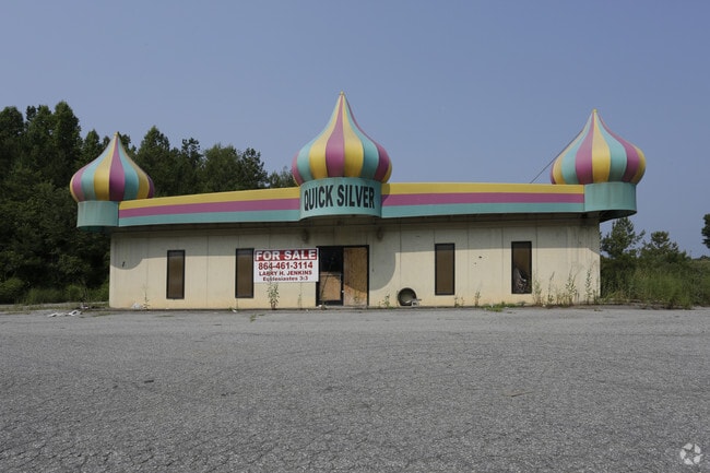
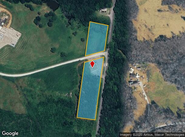
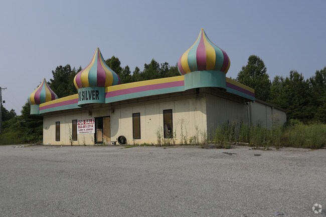
Property Record
1251 Rutherfordton Hwy, Chesnee, SC 29323
NEARBY LISTINGS FOR SALE OR LEASE
Property Detail
1251 Rutherfordton Hwy
004-00-00-001.002
1251 RUTHERFORDTON HWY
Commercialnec
Cherokee
X
South Carolina
45021C0025D
4.50 AC
2025
Cherokee County
2025
Greenville/Spartanburg
022304
Gaffney, SC
4,800 SF
DEMOGRAPHICS near 1251 Rutherfordton Hwy
1 Mile
3 Mile
5 Mile
2024 Total Population
235
5,079
13,225
2029 Population
237
5,496
14,151
Pop Growth 2024-2029
+ 0.85%
+ 8.21%
+ 7.00%
Average Age
42
41
41
2024 Total Households
95
2,037
5,201
HH Growth 2024-2029
+ 1.05%
+ 8.35%
+ 6.96%
Median Household Inc
$49,999
$45,891
$49,679
Avg Household Size
2.40
2.50
2.50
2024 Avg HH Vehicles
2.00
2.00
2.00
Median Home Value
$121,739
$115,151
$129,503
Median Year Built
1991
1986
1987
Nearby Places
Map Layers
Map Styles
 Street
 Aerial
- Restaurants
- Banks
- Shops
- Fitness
- Groceries
PUBLIC TRANSPORTATION
AIRPORT
Greenville Spartanburg International
DRIVE
WALK
Distance
Greenville Spartanburg International
50 min
35.9 mi
Nearby Properties
Address
Land Use
TOTAL SIZE
Lot Size
Zoning
Address
Land Use
TOTAL SIZE
Lot Size
Zoning
4,864 SF
196.52 AC
Address
Land Use
TOTAL SIZE
Lot Size
Zoning
120,000 SF
17.62 AC
Address
Land Use
TOTAL SIZE
Lot Size
Zoning
100,000 SF
15.78 AC
Address
Land Use
TOTAL SIZE
Lot Size
Zoning
80,960 SF
65.19 AC
Address
Land Use
TOTAL SIZE
Lot Size
Zoning
47,265 SF
14.46 AC
Address
Land Use
TOTAL SIZE
Lot Size
Zoning
390.25 AC
Address
Land Use
TOTAL SIZE
Lot Size
Zoning
14,251 SF
1.79 AC
Address
Land Use
TOTAL SIZE
Lot Size
Zoning
426.78 AC
Address
Land Use
TOTAL SIZE
Lot Size
Zoning
3,522 SF
Address
Land Use
TOTAL SIZE
Lot Size
Zoning
7,590 SF
37.99 AC
Address
Land Use
TOTAL SIZE
Lot Size
Zoning
47.62 AC
Address
Land Use
TOTAL SIZE
Lot Size
Zoning
254.86 AC
Address
Land Use
TOTAL SIZE
Lot Size
Zoning
Address
Land Use
TOTAL SIZE
Lot Size
Zoning
81.15 AC
Address
Land Use
TOTAL SIZE
Lot Size
Zoning
Address
Land Use
TOTAL SIZE
Lot Size
Zoning
Address
Land Use
TOTAL SIZE
Lot Size
Zoning
6,780 SF
3.68 AC
Address
Land Use
TOTAL SIZE
Lot Size
Zoning
3,072 SF
0.87 AC
Address
Land Use
TOTAL SIZE
Lot Size
Zoning
Address
Land Use
TOTAL SIZE
Lot Size
Zoning
Address
Land Use
TOTAL SIZE
Lot Size
Zoning
2,620 SF
5.03 AC
Address
Land Use
TOTAL SIZE
Lot Size
Zoning
109.44 AC
Address
Land Use
TOTAL SIZE
Lot Size
Zoning
Address
Land Use
TOTAL SIZE
Lot Size
Zoning
117.84 AC
Address
Land Use
TOTAL SIZE
Lot Size
Zoning
25.65 AC
Address
Land Use
TOTAL SIZE
Lot Size
Zoning
24.53 AC
Address
Land Use
TOTAL SIZE
Lot Size
Zoning
6,303 SF
Address
Land Use
TOTAL SIZE
Lot Size
Zoning
Address
Land Use
TOTAL SIZE
Lot Size
Zoning
86.30 AC
Address
Land Use
TOTAL SIZE
Lot Size
Zoning
3,781 SF
0.23 AC
The World's #1 Commercial Real Estate Marketplace
Connect with us
© 2025 CoStar Group
The information above has been obtained from sources believed reliable. While we do not doubt its accuracy we have not verified it and make no guarantee, warranty or representation about it. It is your responsibility to independently confirm its accuracy and completeness. Any projections, opinions, assumptions, or estimates used are for example only and do not represent the current or future performance of the property. The value of this transaction to you depends on tax and other factors which should be evaluated by your tax, financial, and legal advisors. You and your advisors should conduct a careful, independent investigation of the property to determine to your satisfaction the suitability of the property for your needs.