Property Record
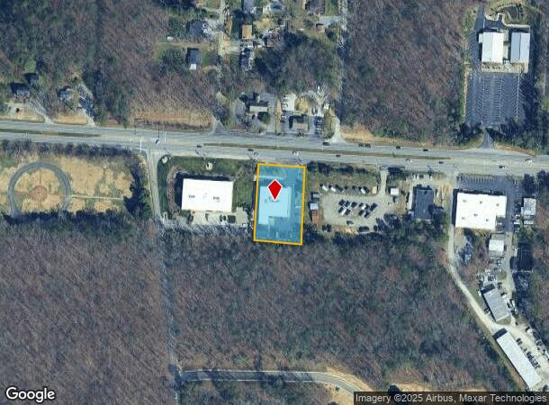
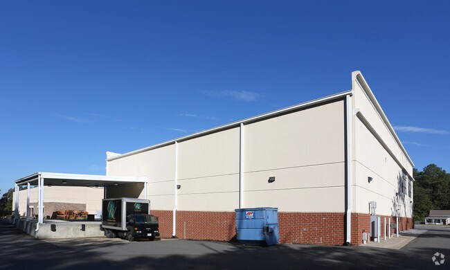
12535 Patterson Ave, Richmond, VA 23238

NEARBY LISTINGS FOR SALE OR LEASE
-
-
View all Richmond listings for sale on LoopNet.com
Property Detail
12535 Patterson Ave
64-1-51
E MANAKIN ON 6 0.97AC #08-1683 PCC 7
Multipleuses
Goochland
X
Virginia
51075C0307C
0.97 AC
2025
Goochland
2025
Richmond VA
400101
Richmond, VA
13,744 SF
DEMOGRAPHICS near 12535 Patterson Ave
1 Mile
3 Mile
5 Mile
2024 Total Population
1,556
31,515
102,197
2029 Population
1,656
31,954
104,558
Pop Growth 2024-2029
+ 6.43%
+ 1.39%
+ 2.31%
Average Age
51
43
42
2024 Total Households
766
12,910
40,222
HH Growth 2024-2029
+ 5.48%
+ 1.48%
+ 2.31%
Median Household Inc
$97,389
$102,056
$112,264
Avg Household Size
2.00
2.40
2.50
2024 Avg HH Vehicles
2.00
2.00
2.00
Median Home Value
$576,316
$408,968
$478,146
Median Year Built
1982
1987
1988
Nearby Places
- Restaurants
- Banks
- Shops
- Fitness
- Groceries
PUBLIC TRANSPORTATION
COMMUTER RAIL
Richmond Staples Mill Road Amtrak Station (Carolinian - Amtrak, Northeast Regional - Amtrak, Palmetto - Amtrak, Silver Meteor - Amtrak)
DRIVE
WALK
Distance
Richmond Staples Mill Road Amtrak Station (Carolinian - Amtrak, Northeast Regional - Amtrak, Palmetto - Amtrak, Silver Meteor - Amtrak)
17 min
9.5 mi
AIRPORT
Richmond International
DRIVE
WALK
Distance
Richmond International
38 min
23.6 mi
Freight Ports
Virginia Port Authority - Richmond
DRIVE
WALK
Distance
Virginia Port Authority - Richmond
35 min
21.9 mi
Nearby Properties
Address
Land Use
TOTAL SIZE
Lot Size
Zoning
Address
Land Use
TOTAL SIZE
Lot Size
Zoning
3,300 SF
286.94 AC
M1-INDUS/L
Address
Land Use
TOTAL SIZE
Lot Size
Zoning
22.47 AC
M1-INDUS/L
Address
Land Use
TOTAL SIZE
Lot Size
Zoning
230,955 SF
48.48 AC
MIXE
Address
Land Use
TOTAL SIZE
Lot Size
Zoning
18 AC
M1-INDUS/L
Address
Land Use
TOTAL SIZE
Lot Size
Zoning
577,728 SF
34.86 AC
R-5
Address
Land Use
TOTAL SIZE
Lot Size
Zoning
26,163 SF
12.02 AC
A-1
Address
Land Use
TOTAL SIZE
Lot Size
Zoning
109,096 SF
50.05 AC
A2R1-AG LT
Address
Land Use
TOTAL SIZE
Lot Size
Zoning
352,296 SF
23.62 AC
R-5
Address
Land Use
TOTAL SIZE
Lot Size
Zoning
271,263 SF
18.81 AC
MIXE
Address
Land Use
TOTAL SIZE
Lot Size
Zoning
1,456 SF
11.71 AC
R-5
Address
Land Use
TOTAL SIZE
Lot Size
Zoning
220,895 SF
77.14 AC
A-1
Address
Land Use
TOTAL SIZE
Lot Size
Zoning
176,520 SF
17.61 AC
R-5
Address
Land Use
TOTAL SIZE
Lot Size
Zoning
35.54 AC
B1-BUS/GEN
Address
Land Use
TOTAL SIZE
Lot Size
Zoning
104,758 SF
15.92 AC
R-5
Address
Land Use
TOTAL SIZE
Lot Size
Zoning
97,890 SF
9.87 AC
R-6
Address
Land Use
TOTAL SIZE
Lot Size
Zoning
219,450 SF
27.74 AC
M1-INDUS/L
Address
Land Use
TOTAL SIZE
Lot Size
Zoning
68,641 SF
6.39 AC
R-1
Address
Land Use
TOTAL SIZE
Lot Size
Zoning
227 AC
M1-INDUS/L
Address
Land Use
TOTAL SIZE
Lot Size
Zoning
102,476 SF
5.41 AC
R-5
Address
Land Use
TOTAL SIZE
Lot Size
Zoning
45,990 SF
35.98 AC
A2-AG/LTD
Address
Land Use
TOTAL SIZE
Lot Size
Zoning
74,444 SF
7.70 AC
R-6C
Address
Land Use
TOTAL SIZE
Lot Size
Zoning
1,968 SF
31.93 AC
MIXE
Address
Land Use
TOTAL SIZE
Lot Size
Zoning
102,904 SF
20 AC
M1-INDUS/L
Address
Land Use
TOTAL SIZE
Lot Size
Zoning
112,700 SF
8.10 AC
R-6
Address
Land Use
TOTAL SIZE
Lot Size
Zoning
52,572 SF
16.04 AC
B-2C
Address
Land Use
TOTAL SIZE
Lot Size
Zoning
68,778 SF
1.41 AC
R-6C
Address
Land Use
TOTAL SIZE
Lot Size
Zoning
105,337 SF
11.25 AC
B-3
Address
Land Use
TOTAL SIZE
Lot Size
Zoning
11,397 SF
57.43 AC
M1-INDUS/L
Address
Land Use
TOTAL SIZE
Lot Size
Zoning
90,889 SF
7.30 AC
M1-INDUS/L
Address
Land Use
TOTAL SIZE
Lot Size
Zoning
90,670 SF
5.96 AC
B-2C
The World's #1 Commercial Real Estate Marketplace
Connect with us
© 2025 CoStar Group
The information above has been obtained from sources believed reliable. While we do not doubt its accuracy we have not verified it and make no guarantee, warranty or representation about it. It is your responsibility to independently confirm its accuracy and completeness. Any projections, opinions, assumptions, or estimates used are for example only and do not represent the current or future performance of the property. The value of this transaction to you depends on tax and other factors which should be evaluated by your tax, financial, and legal advisors. You and your advisors should conduct a careful, independent investigation of the property to determine to your satisfaction the suitability of the property for your needs.