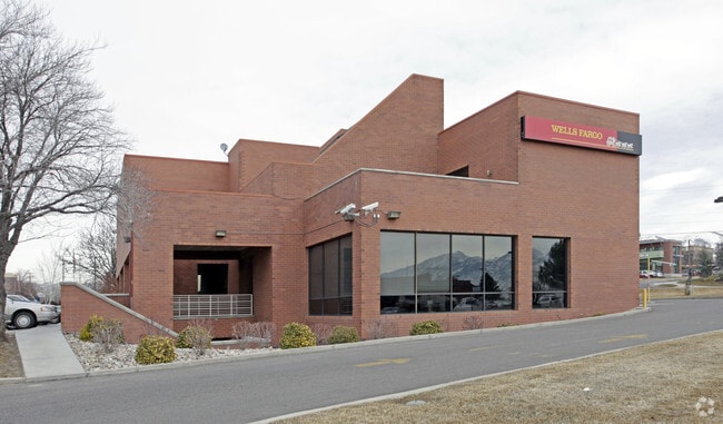
Property Record
1255 E Brickyard Rd, Salt Lake City, UT 84106


Current Lease Availabilities
General Retail LEASE
$11.00 - $16.00 SF/YR
1,082 - 2,173 SF
General Retail LEASE
$11.00 - $17.00 SF/YR
1,082 - 2,173 SF
NEARBY LISTINGS FOR SALE OR LEASE
Property Detail
1255 E Brickyard Rd
16-29-426-017-0000
Radius Curve
Financialbuilding
BEG S 513.98 FT & W 560.13 FT & N 25^1030 W 7.10 FT & NWLY ALG A 1186.28 FT RADIUS CURVE TO R 24.37 FT FR E 1/4 COR OF SEC 29, T 1S, R 1E, SLM; NLY ALG A 1186.28 FT RADIUSCURVE TO R 67.93 FT; N 76^0223 W 27.34 FT; S 66^1254 W 10.63 FT; N 80^4415 W 17
X
Salt Lake
49035C0303G
Utah
2024
1.23 AC
2025
Central Valley East
111802
Salt Lake City
17,051 SF
Salt Lake City, UT
DEMOGRAPHICS near 1255 E Brickyard Rd
1 Mile
3 Mile
5 Mile
2024 Total Population
19,850
159,563
334,922
2029 Population
20,051
161,325
338,685
Pop Growth 2024-2029
+ 1.01%
+ 1.10%
+ 1.12%
Average Age
38
38
38
2024 Total Households
8,472
66,200
138,194
HH Growth 2024-2029
+ 0.98%
+ 1.14%
+ 1.34%
Median Household Inc
$83,333
$74,271
$68,944
Avg Household Size
2.30
2.30
2.30
2024 Avg HH Vehicles
2.00
2.00
2.00
Median Home Value
$465,566
$530,160
$502,412
Median Year Built
1961
1966
1972
Nearby Places
Map Layers
Map Styles
 Street
 Aerial
- Restaurants
- Banks
- Shops
- Fitness
- Groceries
PUBLIC TRANSPORTATION
COMMUTER RAIL
North Temple Station (FrontRunner - Utah Transit Authority (UTA))
DRIVE
WALK
Distance
North Temple Station (FrontRunner - Utah Transit Authority (UTA))
14 min
8.6 mi
Warm Springs Relief Point (FrontRunner - Utah Transit Authority (UTA))
DRIVE
WALK
Distance
Warm Springs Relief Point (FrontRunner - Utah Transit Authority (UTA))
15 min
10.0 mi
AIRPORT
Salt Lake City International
DRIVE
WALK
Distance
Salt Lake City International
18 min
12.6 mi
Freight Ports
Port of Stockton
DRIVE
WALK
Distance
Port of Stockton
718 min
703.0 mi
Nearby Properties
Address
Land Use
TOTAL SIZE
Lot Size
Zoning
Address
Land Use
TOTAL SIZE
Lot Size
Zoning
298,628 SF
27.30 AC
I
Address
Land Use
TOTAL SIZE
Lot Size
Zoning
207,140 SF
23.06 AC
P
Address
Land Use
TOTAL SIZE
Lot Size
Zoning
163,932 SF
14.65 AC
PL
Address
Land Use
TOTAL SIZE
Lot Size
Zoning
257,003 SF
25.87 AC
1108
Address
Land Use
TOTAL SIZE
Lot Size
Zoning
691,463 SF
17.80 AC
RM
Address
Land Use
TOTAL SIZE
Lot Size
Zoning
208,868 SF
20.41 AC
I
Address
Land Use
TOTAL SIZE
Lot Size
Zoning
183,600 SF
10.70 AC
RMF-35
Address
Land Use
TOTAL SIZE
Lot Size
Zoning
128,997 SF
3.04 AC
ESN
Address
Land Use
TOTAL SIZE
Lot Size
Zoning
521,964 SF
3.23 AC
T-O-D
Address
Land Use
TOTAL SIZE
Lot Size
Zoning
297,476 SF
1.62 AC
CSHBD2
Address
Land Use
TOTAL SIZE
Lot Size
Zoning
302,944 SF
5.47 AC
Address
Land Use
TOTAL SIZE
Lot Size
Zoning
369,717 SF
2.50 AC
RO
Address
Land Use
TOTAL SIZE
Lot Size
Zoning
502,104 SF
4.11 AC
E ST C
Address
Land Use
TOTAL SIZE
Lot Size
Zoning
412,006 SF
1.70 AC
C3
Address
Land Use
TOTAL SIZE
Lot Size
Zoning
369,377 SF
1.65 AC
Address
Land Use
TOTAL SIZE
Lot Size
Zoning
426,600 SF
1.61 AC
CSHBD1
Address
Land Use
TOTAL SIZE
Lot Size
Zoning
95,854 SF
15.42 AC
CC
Address
Land Use
TOTAL SIZE
Lot Size
Zoning
903,167 SF
1.90 AC
CSHBD1
Address
Land Use
TOTAL SIZE
Lot Size
Zoning
125,518 SF
11.03 AC
RMZC
Address
Land Use
TOTAL SIZE
Lot Size
Zoning
33,164 SF
6.88 AC
RM
Address
Land Use
TOTAL SIZE
Lot Size
Zoning
347,330 SF
6.91 AC
CC
Address
Land Use
TOTAL SIZE
Lot Size
Zoning
107,416 SF
5.46 AC
CSHBD2
Address
Land Use
TOTAL SIZE
Lot Size
Zoning
56,867 SF
5.33 AC
MIXED
Address
Land Use
TOTAL SIZE
Lot Size
Zoning
28,078 SF
15.33 AC
RM-10
Address
Land Use
TOTAL SIZE
Lot Size
Zoning
303,240 SF
29.21 AC
1205
Address
Land Use
TOTAL SIZE
Lot Size
Zoning
299,673 SF
2.16 AC
C3
Address
Land Use
TOTAL SIZE
Lot Size
Zoning
137,697 SF
5.92 AC
C-2/ZC
Address
Land Use
TOTAL SIZE
Lot Size
Zoning
83,204 SF
12.87 AC
RM
Address
Land Use
TOTAL SIZE
Lot Size
Zoning
213,286 SF
3.67 AC
CG
Address
Land Use
TOTAL SIZE
Lot Size
Zoning
177,906 SF
3.16 AC
RMF-75
The World's #1 Commercial Real Estate Marketplace
Connect with us
© 2025 CoStar Group
The information above has been obtained from sources believed reliable. While we do not doubt its accuracy we have not verified it and make no guarantee, warranty or representation about it. It is your responsibility to independently confirm its accuracy and completeness. Any projections, opinions, assumptions, or estimates used are for example only and do not represent the current or future performance of the property. The value of this transaction to you depends on tax and other factors which should be evaluated by your tax, financial, and legal advisors. You and your advisors should conduct a careful, independent investigation of the property to determine to your satisfaction the suitability of the property for your needs.