Property Record
12551 Us Highway 441, Boynton Beach, FL 33473
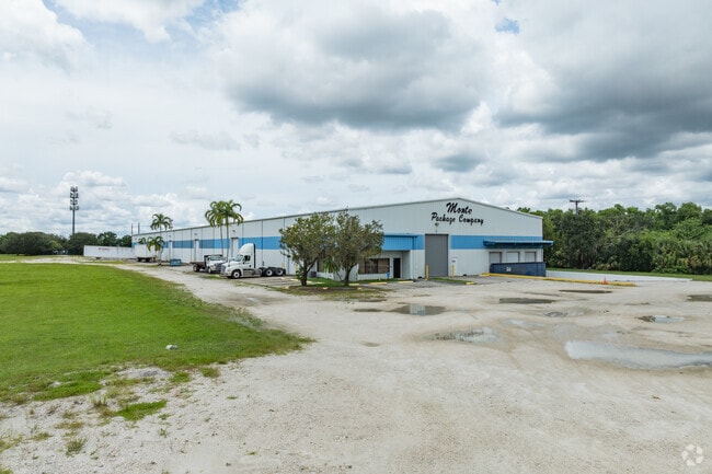

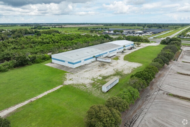
This Property Is For Sale
NEARBY LISTINGS FOR SALE OR LEASE
-
-
View all Boynton Beach listings for sale on LoopNet.com
Property Detail
12551 Us Highway 441
00-41-46-01-01-002-0000
Stj Properties Inc
Warehouse
STJ PROPERTIES INC TR B (LESS ELY 5.77 FT SR 7 R/W)
X
Palm Beach
12099C0955F
Florida
2024
8.83 AC
2025
Palm Bch Cty Outlying
007773
South Florida
45,000 SF
West Palm Beach-Boca Raton-Delray Beach, FL
DEMOGRAPHICS near 12551 Us Highway 441
1 Mile
3 Mile
5 Mile
2024 Total Population
957
21,683
97,041
2029 Population
1,117
23,620
106,466
Pop Growth 2024-2029
+ 16.72%
+ 8.93%
+ 9.71%
Average Age
71
54
58
2024 Total Households
481
9,159
46,782
HH Growth 2024-2029
+ 16.22%
+ 8.57%
+ 9.51%
Median Household Inc
$109,855
$109,585
$72,095
Avg Household Size
2.00
2.30
2.00
2024 Avg HH Vehicles
2.00
2.00
2.00
Median Home Value
$766,929
$562,528
$362,872
Median Year Built
2011
2008
1998
Nearby Places
Map Layers
Map Styles
 Street
 Aerial
- Restaurants
- Banks
- Shops
- Fitness
- Groceries
PUBLIC TRANSPORTATION
AIRPORT
Palm Beach International
DRIVE
WALK
Distance
Palm Beach International
30 min
20.8 mi
Fort Lauderdale/Hollywood International
DRIVE
WALK
Distance
Fort Lauderdale/Hollywood International
50 min
35.6 mi
Freight Ports
Port of Palm Beach
DRIVE
WALK
Distance
Port of Palm Beach
42 min
28.0 mi
Nearby Properties
Address
Land Use
TOTAL SIZE
Lot Size
Zoning
Address
Land Use
TOTAL SIZE
Lot Size
Zoning
259,086 SF
44.59 AC
MUPD
Address
Land Use
TOTAL SIZE
Lot Size
Zoning
271,889 SF
36.72 AC
TMD
Address
Land Use
TOTAL SIZE
Lot Size
Zoning
250,290 SF
10.43 AC
PUD
Address
Land Use
TOTAL SIZE
Lot Size
Zoning
271,613 SF
33 AC
MUPD/P
Address
Land Use
TOTAL SIZE
Lot Size
Zoning
224,197 SF
12.47 AC
PUD
Address
Land Use
TOTAL SIZE
Lot Size
Zoning
161,858 SF
19.49 AC
MUPD
Address
Land Use
TOTAL SIZE
Lot Size
Zoning
126,145 SF
128.55 AC
PO
Address
Land Use
TOTAL SIZE
Lot Size
Zoning
88,456 SF
10.85 AC
MUPD
Address
Land Use
TOTAL SIZE
Lot Size
Zoning
146,573 SF
7.50 AC
MUPD
Address
Land Use
TOTAL SIZE
Lot Size
Zoning
124,342 SF
40.91 AC
PO
Address
Land Use
TOTAL SIZE
Lot Size
Zoning
209,539 SF
36.58 AC
AGR
Address
Land Use
TOTAL SIZE
Lot Size
Zoning
89,511 SF
14.73 AC
MUPD
Address
Land Use
TOTAL SIZE
Lot Size
Zoning
88,125 SF
13.92 AC
AGR
Address
Land Use
TOTAL SIZE
Lot Size
Zoning
4,488 SF
52.12 AC
MUPD/P
Address
Land Use
TOTAL SIZE
Lot Size
Zoning
4,800 SF
39.40 AC
MUPD/P
Address
Land Use
TOTAL SIZE
Lot Size
Zoning
34,010 SF
4.90 AC
MUPD
Address
Land Use
TOTAL SIZE
Lot Size
Zoning
97,182 SF
77.58 AC
IPF
Address
Land Use
TOTAL SIZE
Lot Size
Zoning
67,907 SF
0.68 AC
MUPD
Address
Land Use
TOTAL SIZE
Lot Size
Zoning
30,517 SF
4.48 AC
MUPD
Address
Land Use
TOTAL SIZE
Lot Size
Zoning
76,952 SF
16.60 AC
TMD
Address
Land Use
TOTAL SIZE
Lot Size
Zoning
28,227 SF
485.85 AC
PC
Address
Land Use
TOTAL SIZE
Lot Size
Zoning
36,214 SF
10.80 AC
MUPD
Address
Land Use
TOTAL SIZE
Lot Size
Zoning
25,720 SF
2.69 AC
MUPD
Address
Land Use
TOTAL SIZE
Lot Size
Zoning
313.37 AC
AGRPUD/P
Address
Land Use
TOTAL SIZE
Lot Size
Zoning
13.06 AC
MUPD
Address
Land Use
TOTAL SIZE
Lot Size
Zoning
46,149 SF
5.21 AC
Address
Land Use
TOTAL SIZE
Lot Size
Zoning
25,432 SF
9.23 AC
AGR
Address
Land Use
TOTAL SIZE
Lot Size
Zoning
8,571 SF
9.11 AC
MUPD
Address
Land Use
TOTAL SIZE
Lot Size
Zoning
33,577 SF
6.80 AC
AGR
Address
Land Use
TOTAL SIZE
Lot Size
Zoning
23,052 SF
6.71 AC
IPF
The World's #1 Commercial Real Estate Marketplace
Connect with us
© 2025 CoStar Group
The information above has been obtained from sources believed reliable. While we do not doubt its accuracy we have not verified it and make no guarantee, warranty or representation about it. It is your responsibility to independently confirm its accuracy and completeness. Any projections, opinions, assumptions, or estimates used are for example only and do not represent the current or future performance of the property. The value of this transaction to you depends on tax and other factors which should be evaluated by your tax, financial, and legal advisors. You and your advisors should conduct a careful, independent investigation of the property to determine to your satisfaction the suitability of the property for your needs.