Property Record
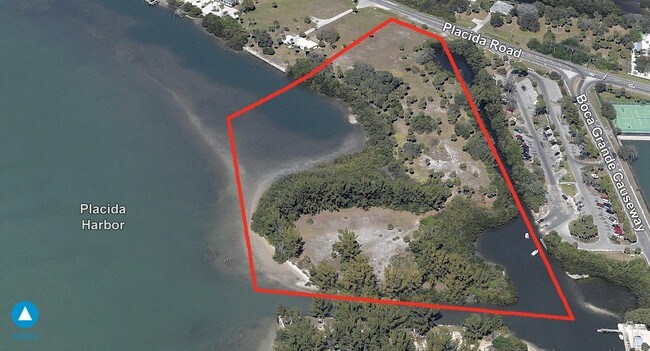
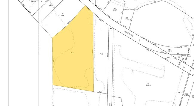
12560 Placida Rd, Placida, FL 33946

Property Detail
12560 Placida Rd
422012301002
12 42 20 P-8-1 14.378 AC. M/L COMM NW COR SEC12 S ALG SEC LN 2073.74 FT TO SW/LY R/W COUNTY RD 775 SE ALG SAID R/W 941.68 FT FOR POB CONT ALG SAID R/W 146.26 FT S 1181.06 FT W 448.20 FT N 699.41 FT NE 690.82 FT TO POB 407/766 1012/1708 18
Commercialacreage
CHARLOTTE
II
Florida
AE The base floodplain where base flood elevations are provided. AE Zones are now used on new format FIRMs instead of A1-A30 Zones.
14.21 AC
2024
Charlotte County
2025
Southwest Florida
030504
Punta Gorda, FL
NEARBY LISTINGS FOR SALE OR LEASE
DEMOGRAPHICS near 12560 Placida Rd
1 mile
3 mile
5 mile
2025 Total Population
703
2,850
16,719
2030 Population
766
3,213
18,805
Pop Growth 2025-2030
+ 8.96%
+ 12.74%
+ 12.48%
Average Age
58
62
61
2025 Total Households
327
1,431
8,323
HH Growth 2025-2030
+ 8.56%
+ 12.65%
+ 12.33%
Median Household Inc
$84,693
$87,762
$82,120
Avg Household Size
2.10
2.00
2.00
2025 Avg HH Vehicles
2.00
2.00
2.00
Median Home Value
$684,895
$580,196
$443,174
Median Year Built
1996
1998
1999
Nearby Places
Map Layers
Map Styles
 Street
 Aerial
Transit
 Traffic
 Biking
Places
Listings with unknown addresses are not visible on the map
- Restaurants
- Banks
- Shops
- Fitness
- Groceries
PUBLIC TRANSPORTATION
AIRPORT
Punta Gorda
Drive
Walk
Distance
Punta Gorda
50 min
28.6 mi
Freight Ports
Port Manatee
Drive
Walk
Distance
Port Manatee
92 min
64.5 mi
Nearby Properties
Address
Land Use
TOTAL SIZE
Lot Size
Zoning
Address
Land Use
TOTAL SIZE
Lot Size
Zoning
2,387.99 AC
ES
Address
Land Use
TOTAL SIZE
Lot Size
Zoning
70,336 SF
29.71 AC
II
Address
Land Use
TOTAL SIZE
Lot Size
Zoning
32,041 SF
202.06 AC
CT
Address
Land Use
TOTAL SIZE
Lot Size
Zoning
42,935 SF
167.66 AC
RE1
Address
Land Use
TOTAL SIZE
Lot Size
Zoning
2,473 SF
26.16 AC
PUBLIC
Address
Land Use
TOTAL SIZE
Lot Size
Zoning
4,742 SF
13.09 AC
PD
Address
Land Use
TOTAL SIZE
Lot Size
Zoning
12,444 SF
2.91 AC
CT
Address
Land Use
TOTAL SIZE
Lot Size
Zoning
98,534 SF
24.84 AC
CG
Address
Land Use
TOTAL SIZE
Lot Size
Zoning
4,326 SF
31.99 AC
MHP
Address
Land Use
TOTAL SIZE
Lot Size
Zoning
324 SF
11.52 AC
CT
Address
Land Use
TOTAL SIZE
Lot Size
Zoning
40,376 SF
11.18 AC
CG
Address
Land Use
TOTAL SIZE
Lot Size
Zoning
3,935 SF
36.92 AC
RMF10
Address
Land Use
TOTAL SIZE
Lot Size
Zoning
5.61 AC
II
Address
Land Use
TOTAL SIZE
Lot Size
Zoning
18,107 SF
11.88 AC
RMF5
Address
Land Use
TOTAL SIZE
Lot Size
Zoning
27,501 SF
3.82 AC
CG
Address
Land Use
TOTAL SIZE
Lot Size
Zoning
20,160 SF
3.04 AC
CG
Address
Land Use
TOTAL SIZE
Lot Size
Zoning
8.47 AC
RMF10
Address
Land Use
TOTAL SIZE
Lot Size
Zoning
10 AC
RMF10
Address
Land Use
TOTAL SIZE
Lot Size
Zoning
1.34 AC
RSF3.5
Address
Land Use
TOTAL SIZE
Lot Size
Zoning
6,210 SF
10.94 AC
RSF3.5
Address
Land Use
TOTAL SIZE
Lot Size
Zoning
0.32 AC
RSF3.5
Address
Land Use
TOTAL SIZE
Lot Size
Zoning
1.86 AC
RSF3.5
Address
Land Use
TOTAL SIZE
Lot Size
Zoning
13,682 SF
4.46 AC
CG
Address
Land Use
TOTAL SIZE
Lot Size
Zoning
3.09 AC
RSF3.5
Address
Land Use
TOTAL SIZE
Lot Size
Zoning
0.80 AC
RSF3.5
Address
Land Use
TOTAL SIZE
Lot Size
Zoning
8,700 SF
95.10 AC
RSF3.5
Address
Land Use
TOTAL SIZE
Lot Size
Zoning
0.62 AC
RSF3.5
Address
Land Use
TOTAL SIZE
Lot Size
Zoning
7,243 SF
1.06 AC
CG
Address
Land Use
TOTAL SIZE
Lot Size
Zoning
4.37 AC
PD
The World's #1 Commercial Real Estate Marketplace
Connect with us
© 2026 CoStar Group
The information above has been obtained from sources believed reliable. While we do not doubt its accuracy we have not verified it and make no guarantee, warranty or representation about it. It is your responsibility to independently confirm its accuracy and completeness. Any projections, opinions, assumptions, or estimates used are for example only and do not represent the current or future performance of the property. The value of this transaction to you depends on tax and other factors which should be evaluated by your tax, financial, and legal advisors. You and your advisors should conduct a careful, independent investigation of the property to determine to your satisfaction the suitability of the property for your needs.